Overview
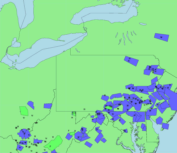
Numerous severe thunderstorms erupted across south central and southeastern Pennsylvania during the late afternoon on July 18th, 2006. These storms formed in a high buoyancy, weak sheared environment resulting in strong updrafts that produced a lot of wind damage and large hail. The graphical plot of severe weather reports and warnings show the extent of this event. In Central Pennsylvania there were numerous reports of hail and strong winds. Local public and spotters also reported severe weather.
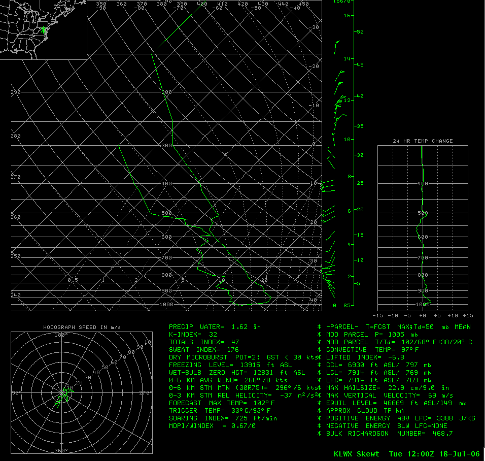
The morning soundings showed the potential for strong updrafts. The KLWX 1200 UTC sounding showed large CAPE values of 3388 J/KG. A special 1700 UTC sounding was launched which showed the CAPE had decreased to 2476 J/KG but was still fairly high. Both soundings showed very weak vertical wind shear indicating the main severe weather threat would be hail and strong winds instead of tornadoes.
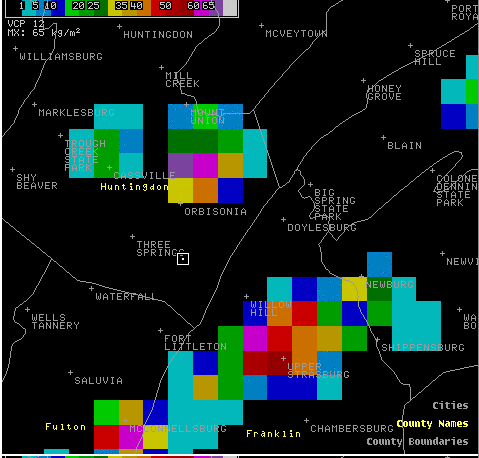
Early in the event 2 large storms formed over Huntingdon and Franklin counties at 20:00 UTC. These storms continued to move east and produce nickel size hail at 20:15 UTC (4:15 pm) at Mapleton in Huntingdon county. The Vertically Integrated Liquid radar product at 20:04 UTC (4:04 pm) shows the potential for large hail across Huntingdon and Franklin counties. A 2-panel reflectivity and storm relative velocity loop shows these 2 storms moving across Huntingdon and Franklin counties between 19:43 UTC (3:43 pm) and 20:13 UTC (4:13 pm).
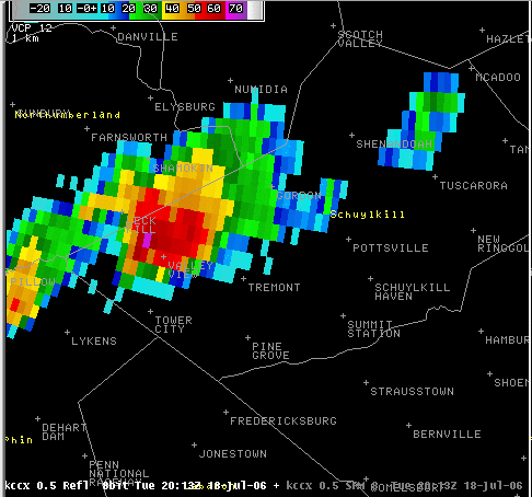
Another strong storm developed in western Schuylkill county around 20:00 UTC and produced marble to nickel sized hail and strong winds as it moved east. A 2-panel radar image loop of reflectivity and storm relative velocity shows the storm tracking east across Schuylkill county between 20:00 UTC and 20:31 UTC.
In York county a storm produced 1.00 inch diameter hail 5 miles east of Codorus at 22:00 UTC (6:00 pm).
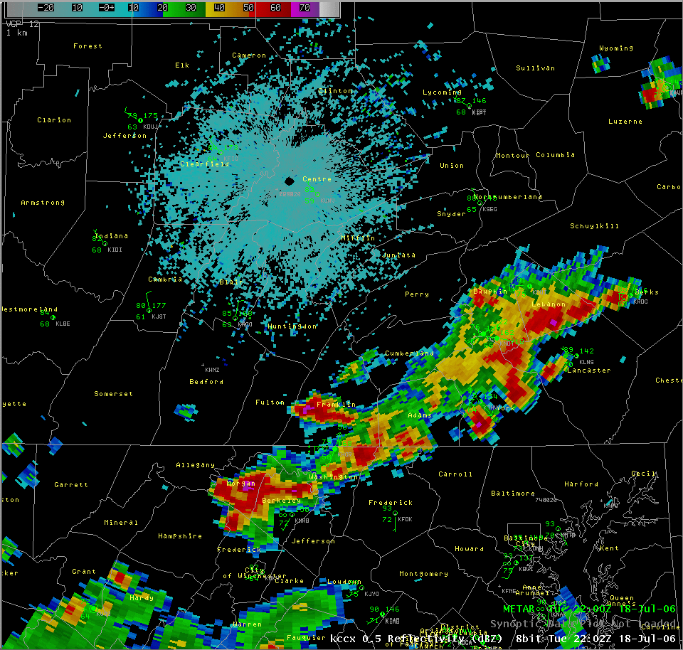
By 22:00 UTC (6:00 pm) there was a line of severe thunderstorms stretching from Lebanon county southwest to York county. At 22:15 (6:15 pm) radar showed a strong storm over western Lancaster county. At this time a local trained spotter estimated wind gusts of 50 to 60 MPH at Neffville in Lancaster county.
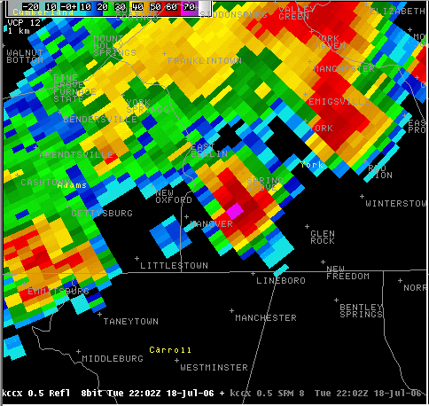
Also in Lancaster county at 6:30 pm a large tree blew down across the road in Ephrata and the power was out. An Emergency Manager reported that a barn was blown down and several homes were damaged by fallen trees at 6:45 pm in Churchtown in extreme eastern Lancaster county. Radar showed these strong storms moving across eastern Lancaster county at 22:30 UTC (6:30 pm) and 22:45 UTC (6:45 pm).
 |
 |
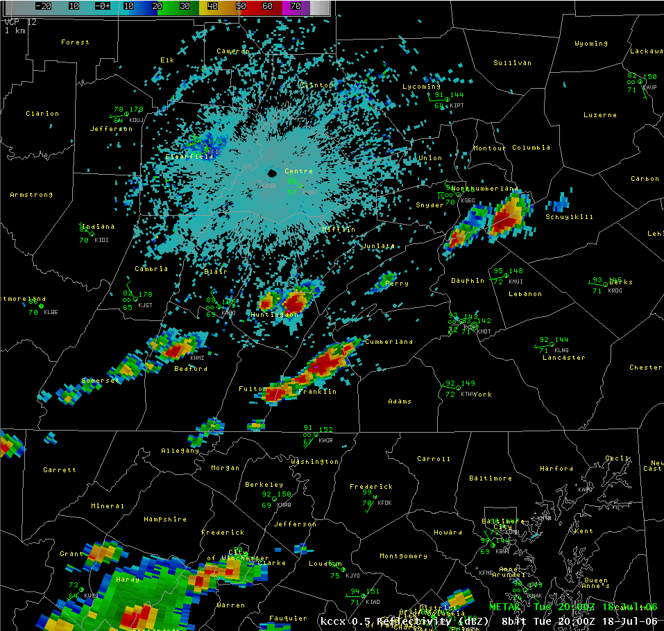 |
| Local Storm Reports and Warnings | KLWX 1200 UTC upper air sounding showing high CAPE and weak shear. | Storms erupting across Huntingdon and Franklin counties at 2000 UTC (4:00 pm). |
Radar
 |
 |
 |
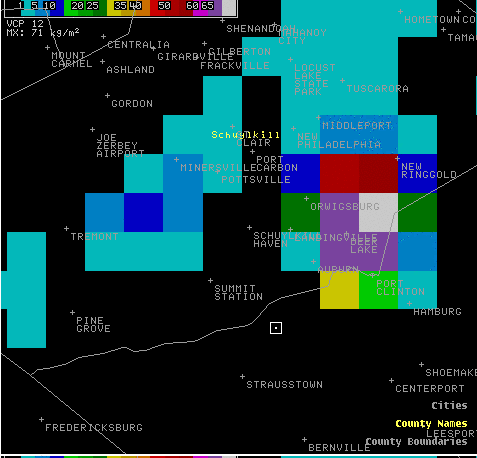 |
| Vertically Integrated Liquid radar image at 20:04 UTC (4:04 pm). Purple colors indicate potential for large hail in Huntingdon and Franklin counties. | Storms stretching from Lebanon county southwest to York county at 22:02 UTC (6:02 pm). | Storm over Schuylkill county producing penny size hail and wind gusts of 60 mph at Spring Glen at 20:15 UTC (4:15 pm). | Vertically Integrated Liquid radar image at 20:59 UTC (4:59 pm). Purple and white colors indicate potential for large hail over eastern Schuylkill county. |
 |
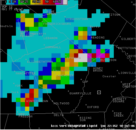 |
| York county storm producing 1.00 inch diameter hail 5 miles east of Codorus at 22:00 UTC (6:00 pm). A radar loop also shows the storms moving across York county between 21:45 UTC (6:45 pm) and 22:19 UTC (6:19 pm). | Vertically Integrated Liquid radar image at 22:35 UTC (6:35 pm). Purple and white colors indicate potential for large hail over northeastern Lancaster county. At 6:30 pm a large tree blew down across the road in Ephrata and the power was out. |
Storm Reports
000
NWUS51 KCTP 190120
LSRCTP
PRELIMINARY LOCAL STORM REPORT...CORRECTED
NATIONAL WEATHER SERVICE STATE COLLEGE PA
920 PM EDT TUE JUL 18 2006
..TIME... ...EVENT... ...CITY LOCATION... ...LAT.LON...
..DATE... ....MAG.... ..COUNTY LOCATION..ST.. ...SOURCE....
..REMARKS..
0410 PM TSTM WND DMG 5 W VALLEY VIEW 40.66N 76.63W
07/18/2006 SCHUYLKILL PA COUNTY OFFICIAL
911 CENTER REPORTED TREE DOWN IN TOWN OF SACRAMENTO,
HUBLEY TOWNSHIP.
0415 PM TSTM WND GST 6 W VALLEY VIEW 40.66N 76.64W
07/18/2006 E60.00 MPH SCHUYLKILL PA COUNTY OFFICIAL
FIRE DEPT. CHIEF REPORTED TO 911 CENTER THAT PENNY SIZED
HAIL AND ESTIMATED WIND GUSTS OF 60 MPH WERE OCCURRING AT
SPRING GLEN.
0415 PM HAIL N CHAMBERSBURG 39.93N 77.66W
07/18/2006 E0.50 INCH FRANKLIN PA TRAINED SPOTTER
0415 PM HAIL MAPLETON 40.39N 77.94W
07/18/2006 E0.88 INCH HUNTINGDON PA TRAINED SPOTTER
SPOTTER REPORTED TO NWS PITTSBURGH WITHOUT A TIME. TIME
WAS DETERMINED BASED ON RADAR.
0415 PM HAIL 6 W VALLEY VIEW 40.66N 76.64W
07/18/2006 E0.75 INCH SCHUYLKILL PA COUNTY OFFICIAL
FIRE DEPT. CHIEF REPORTED PENNY SIZED HAIL AND ESTIMATED
WIND GUSTS OF 60 MPH.
0430 PM TSTM WND DMG 5 E VALLEY VIEW 40.66N 76.43W
07/18/2006 SCHUYLKILL PA COUNTY OFFICIAL
911 CENTER REPORTED TREES AND WIRES DOWN IN HEGINS
TOWNSHIP.
0440 PM HAIL NW CHAMBERSBURG 39.93N 77.66W
07/18/2006 M0.88 INCH FRANKLIN PA NWS EMPLOYEE
NWS EMPLOYEE REPORTED NICKEL SIZED HAIL NEAR TOWN OF
UPPER STRASBURG.
0450 PM HAIL 5 E CODORUS 39.79N 76.73W
07/18/2006 E0.50 INCH YORK PA TRAINED SPOTTER
SPOTTER REPORTED PEA TO MARBLE SIZED HAIL AT DOVER. WIND
GUSTS WERE ESTIMATED AT 25 TO 30 MPH.
0450 PM TSTM WND DMG YORK SPRINGS 40.01N 77.12W
07/18/2006 ADAMS PA TRAINED SPOTTER
TREES AND WIRES DOWN 3 MILES NORTHEAST OF YORK SPRINGS IN
TOWN OF LATIMER. ELECTRIC POWER OFF.
0450 PM HAIL 3 ENE BENDERSVILLE 40.00N 77.20W
07/18/2006 E0.75 INCH ADAMS PA PUBLIC
LARGE HAIL REPORTED AT GARDNERS.
0450 PM HAIL FORT LOUDON 39.94N 77.87W
07/18/2006 M0.88 INCH FRANKLIN PA PUBLIC
REPORT OF 0.88 INCH HAIL.
0450 PM HAIL 3 NE CAMP HILL 40.28N 76.88W
07/18/2006 E0.25 INCH DAUPHIN PA TRAINED SPOTTER
DIME SIZED HAIL IN LOWER SWATARA TOWNSHIP NEAR
MIDDLETOWN.
0450 PM HAIL N GREENCASTLE 39.79N 77.73W
07/18/2006 E1.00 INCH FRANKLIN PA TRAINED SPOTTER
LARGE HAIL. LITTLE WIND.
0450 PM HAIL 2 E AUBURN 40.60N 76.06W
07/18/2006 E1.00 INCH SCHUYLKILL PA PUBLIC
LARGE HAIL NEAR JUNCTION OF RTES 61 AND 895 IN DEER LAKE.
LARGE TREES DOWN IN AREA.
0450 PM TSTM WND DMG MERCERSBURG 39.83N 77.90W
07/18/2006 FRANKLIN PA COUNTY OFFICIAL
911 CENTER REPORTED POWER POLES BLOWN DOWN AND TREES ON
WIRES.
0450 PM HAIL CHAMBERSBURG 39.93N 77.66W
07/18/2006 E0.75 INCH FRANKLIN PA COUNTY OFFICIAL
911 CENTER REPORTED DIME AND PENNY SIZED HAIL AT
CHAMBERSBURG.
0455 PM HAIL FAYETTEVILLE 39.91N 77.57W
07/18/2006 E0.25 INCH FRANKLIN PA TRAINED SPOTTER
SPOTTER REPORTED DIME SIZED HAIL AND ESTIMATED WIND GUSTS
OF 50 MPH.
0455 PM TSTM WND DMG GETTYSBURG 39.83N 77.23W
07/18/2006 ADAMS PA TRAINED SPOTTER
TREES AND LIMBS DOWN.
0500 PM HAIL CHAMBERSBURG 39.93N 77.66W
07/18/2006 E0.88 INCH FRANKLIN PA PUBLIC
NICKEL SIZED HAIL.
0500 PM HAIL FAYETTEVILLE 39.91N 77.57W
07/18/2006 E0.75 INCH FRANKLIN PA TRAINED SPOTTER
PENNY SIZED HAIL.
0500 PM HAIL GREENCASTLE 39.79N 77.73W
07/18/2006 E0.75 INCH FRANKLIN PA TRAINED SPOTTER
PENNY SIZED HAIL.
0600 PM TSTM WND DMG CORNWALL 40.27N 76.41W
07/18/2006 LEBANON PA EMERGENCY MNGR
EMA REPORTED TREES ON CARS. A DECK WAS ALSO REPORTED
DAMAGED BY WIND.
0600 PM HAIL 5 E CODORUS 39.79N 76.73W
07/18/2006 E1.00 INCH YORK PA TRAINED SPOTTER
LARGE HAIL AT HANOVER.
0605 PM HAIL 4 NNW SPRY 39.96N 76.73W
07/18/2006 E0.75 INCH YORK PA TRAINED SPOTTER
PENNY SIZED HAIL AT HANOVER.
0605 PM HAIL 4 NNW SPRY 39.96N 76.73W
07/18/2006 E0.88 INCH YORK PA TRAINED SPOTTER
NICKEL SIZED HAIL REPORTED AT DOVER.
0610 PM TSTM WND DMG MOUNT JOY 40.11N 76.51W
07/18/2006 LANCASTER PA EMERGENCY MNGR
EMA REPORTED TREES DOWN COUNTY WIDE. TREES FELL ON
HOUSES. THE 1ST REPORT WAS AT 610 PM IN MT. JOY WITH
SUBSEQUENT REPORTS OF TREES ON HOMES IN PETERSBURG AND
LANCASTER.
0610 PM TSTM WND DMG MOUNT JOY 40.11N 76.51W
07/18/2006 LANCASTER PA COUNTY OFFICIAL
911 CENTER REPORTED NUMEROUS TREES AND WIRES DOWN IN
MOUNT JOY AREA.
0615 PM HAIL N HERSHEY 40.28N 76.65W
07/18/2006 E0.75 INCH DAUPHIN PA TRAINED SPOTTER
SPOTTER REPORTED PENNY SIZED HAIL, SOME BRANCHES DOWN
FROM WIND AND MINOR FLOODING.
0615 PM TSTM WND GST 5 SE EAST PETERSBURG 40.04N 76.30W
07/18/2006 E50.00 MPH LANCASTER PA TRAINED SPOTTER
SPOTTER ESTIMATED WIND AT 50 TO 60 MPH AT NEFFVILLE
0618 PM HAIL 4 NNW SPRY 39.96N 76.73W
07/18/2006 E0.88 INCH YORK PA TRAINED SPOTTER
SPOTTER REPORTED NICKEL SIZED HAIL AT JEFFERSON ABOUT 7
MILES EAST OF HANOVER.
0625 PM HAIL BRICKERVILLE 40.23N 76.29W
07/18/2006 E0.75 INCH LANCASTER PA TRAINED SPOTTER
PENNY SIZED HAILED REPORTED NEAR THE JUNTION OF ROUTES
322 AND 501 IN MEYERSTOWN.
0625 PM TSTM WND DMG LANCASTER 40.04N 76.30W
07/18/2006 LANCASTER PA COUNTY OFFICIAL
911 CENTER REPORTED NUMEROUS TREES AND WIRES DOWN.
0630 PM TSTM WND DMG EPHRATA 40.18N 76.18W
07/18/2006 LANCASTER PA TRAINED SPOTTER
LARGE TREE ACROSS ROAD IN EPHRATA. POWER OUT.
0645 PM TSTM WND DMG CHURCHTOWN 40.14N 75.95W
07/18/2006 LANCASTER PA EMERGENCY MNGR
EMA REPORTED THAT A BARN WAS BLOWN DOWN AND SEVERAL HOMES
WERE DAMAGED BY FALLEN TREES.
0646 PM HAIL 4 E NEW HOLLAND 40.10N 76.01W
07/18/2006 E0.25 INCH LANCASTER PA TRAINED SPOTTER
PEA SIZED HAIL AND WIND GUSTING AROUND 40 TO 45 MPH AT
EAST EARL.
0705 PM HEAVY RAIN HERSHEY 40.28N 76.65W
07/18/2006 M1.29 INCH DAUPHIN PA TRAINED SPOTTER
SPOTTER REPORTED 1.29 INCHES OF RAIN WITH THUNDERSTORMS
THIS EVENING.
0715 PM TSTM WND GST 2 SSE NEW HOLLAND 40.07N 76.08W
07/18/2006 M52.00 MPH LANCASTER PA PUBLIC
FRIEND OF COOPERATIVE WEATHER OBSERVER AT NEW HOLLAND
MEASURED PEAK WIND IN THUNDERSTORM.
0720 PM HAIL TERRE HILL 40.16N 76.05W
07/18/2006 E1.75 INCH LANCASTER PA PUBLIC
FRIEND OF NEW HOLLAND COOPERATIVE WEATHER OBSERVER
REPORTED GOLF BALL SIZED HAIL 7 MILES NORTHEAST OF NEW
HOLLAND.
0725 PM HAIL N MEYERSDALE 39.81N 79.03W
07/18/2006 E0.25 INCH SOMERSET PA TRAINED SPOTTER
SPOTTER REPORTED LARGE PEA SIZED HAIL.
0815 PM HEAVY RAIN NEW HOLLAND 40.10N 76.09W
07/18/2006 M1.23 INCH LANCASTER PA CO-OP OBSERVER
OBSERVER REPORTED 1.23 INCHES OF RAIN WITH THUNDERSTORM
THIS EVENING.
&&
$$
MACH
 |
Media use of NWS Web News Stories is encouraged! Please acknowledge the NWS as the source of any news information accessed from this site. |
 |