A Pacific storm system will bring strong winds and low elevation rain to much of the West Coast, and heavy high elevation mountain snow to the Sierra-Nevada through Wednesday. Fire weather concerns will continue into Tuesday across the Mid-South and Southeast as gusty winds and dry conditions persist. Read More >
Overview
|
June 9th turned out to be a very busy day - with early reports totalling more than 10 severe events (and many sub- severe hail and wind events) occurring from late morning to the evening. The wet-bulb zero level of around 6-7kft AGL and freezing level near 8kft (over the higher ground of Central PA vs. KPIT) helped many cells to produce hail early and throughout their lifetimes. The storms were aided by a strong wind profile at all levels - much stronger than the severe pulse storms of May 30th and 31st. This wind profile eventually lead to more organization to the cells, but as with the events two weeks before, the thunderstorms started out as mainly pulse thunderstorms with short durations/life-spans, fired up by the (modest) heating of the day. |
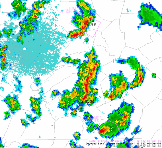
 KCCX 0.5° Reflectivity from 1751z (151PM EDT) with warning box plots and Spotter Storm Reports overlaid. Later in the afternoon, the storms had evolved from scattered cells into a bit of linear/mini-bow-echo organization thanks to the strong NW winds aloft. Many storms produced wind damage and large hail. See two of the reports we received from spotters and law enforcement officials plotted in black (one near Williamsport - A=Hail 0.88=diameter in inches - and another report west of Harrisburg). Current warnings (outlines) are also seen in pink on this picture. |
 |
 |
 |
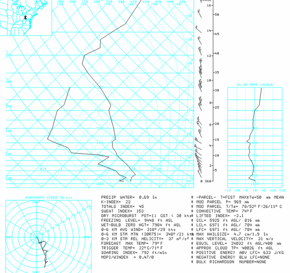
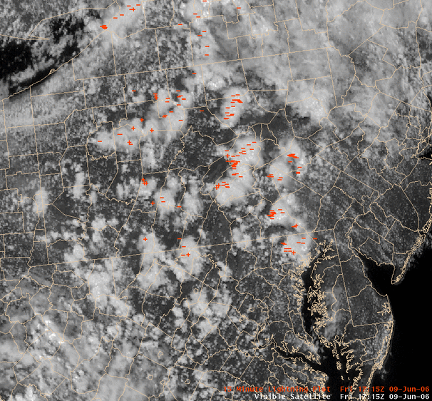
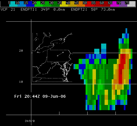
| Pittsburgh, PA (KPIT) morning (12z) SkewT Balloon Sounding Note the strong winds aloft (reaching 55kts by 20kft, and as high as 99kts around 35kft). The Convective Temperature (temperature at which cumulus clouds will start to grow) of 74°F was reched very early in the day. Modest/respectable CAPEs of 600 to 700 J/kg were possible, and were most likely realized by late that morning. | Visible Satellite Pic from 1715z (115 PM EDT) with past 15 minutes of Cloud to Ground Lightning Strikes (CGs) overlaid. Note the widespread thunderstorm activity by 1 PM! They started early and lasted into the early evening. | KCCX Reflectivity Cross Section from 2044z (444PM EDT) from storm near Williamsport. Note the storm reached up to 28kft or so...with a strong reflectivity core held aloft (strong updraft) in an excellent place for hail generation/growth (above the wet-bulb zero and freezing levels all the way to the top of the storm cell). The storm was also apparently able to tap the 50+kt winds at the top of the storm cell (see SkewT above), and bring them down to the surface, as it blew a couple of trees down in western Lycoming County. |
Storm Reports
NWUS51 KCTP 100014 CCA
LSRCTP
PRELIMINARY LOCAL STORM REPORT...CORRECTED
NATIONAL WEATHER SERVICE STATE COLLEGE PA
812 PM EDT FRI JUN 09 2006
..TIME... ...EVENT... ...CITY LOCATION... ...LAT.LON...
..DATE... ....MAG.... ..COUNTY LOCATION..ST.. ...SOURCE....
..REMARKS..
1140 AM HAIL MECHANICSBURG 40.21N 77.01W
06/09/2006 E0.88 INCH CUMBERLAND PA PUBLIC
1140 AM HAIL NEW CUMBERLAND 40.23N 76.88W
06/09/2006 E0.75 INCH CUMBERLAND PA TRAINED SPOTTER
PENNY SIZE HAIL WITH HEAVY RAIN
1200 PM HAIL HANOVER 39.81N 76.98W
06/09/2006 E1.00 INCH YORK PA LAW ENFORCEMENT
TRAFFIC ACCIDENT ATTRIBUTED TO STORM.
1240 PM HAIL DILLSBURG 40.11N 77.03W
06/09/2006 E0.25 INCH YORK PA PUBLIC
1245 PM HAIL ELIZABETHVILLE 40.55N 76.82W
06/09/2006 E0.50 INCH DAUPHIN PA TRAINED SPOTTER
1250 PM HAIL ELIZABETHVILLE 40.55N 76.82W
06/09/2006 M0.88 INCH DAUPHIN PA PUBLIC
0102 PM HAIL AUSTIN 41.64N 78.09W
06/09/2006 E0.25 INCH POTTER PA PUBLIC
0105 PM HAIL DOVER 40.00N 76.85W
06/09/2006 E0.25 INCH YORK PA PUBLIC
NUMEROUS PEA SIZE HAIL ACCOMPANIED BY WINDS GUSTING TO 50
MPH.
0115 PM HAIL MIDDLEBURG 40.79N 77.05W
06/09/2006 E0.25 INCH SNYDER PA EMERGENCY MNGR
0130 PM HAIL MEISERVILLE 40.67N 76.95W
06/09/2006 E0.88 INCH SNYDER PA LAW ENFORCEMENT
0135 PM HAIL WILLIAMSPORT 41.24N 77.02W
06/09/2006 E0.25 INCH LYCOMING PA TRAINED SPOTTER
0140 PM HAIL WILLIAMSPORT 41.24N 77.02W
06/09/2006 E0.88 INCH LYCOMING PA TRAINED SPOTTER
0149 PM HAIL SHIREMANSTOWN 40.22N 76.96W
06/09/2006 E0.50 INCH CUMBERLAND PA TRAINED SPOTTER
0152 PM HAIL MONTOURSVILLE 41.25N 76.92W
06/09/2006 E0.88 INCH LYCOMING PA TRAINED SPOTTER
HEAVY RAIN OF 3/4 INCH PER HOUR ALSO WINDS GUSTING 35-40
MPH.
0158 PM HAIL MOUNT GRETNA 40.25N 76.47W
06/09/2006 E0.50 INCH LEBANON PA TRAINED SPOTTER
0158 PM HAIL WEST FAIRVIEW 40.28N 76.92W
06/09/2006 E0.25 INCH CUMBERLAND PA LAW ENFORCEMENT
0159 PM TSTM WND GST SHIREMANSTOWN 40.22N 76.96W
06/09/2006 E53.00 MPH CUMBERLAND PA TRAINED SPOTTER
0200 PM HAIL MONTOURSVILLE 41.25N 76.92W
06/09/2006 M0.75 INCH LYCOMING PA PUBLIC
0200 PM HAIL JACOBUS 39.88N 76.71W
06/09/2006 M0.75 INCH YORK PA PUBLIC
0215 PM TSTM WND DMG MILLERSBURG 40.54N 76.96W
06/09/2006 DAUPHIN PA LAW ENFORCEMENT
TWO TREES KNOCKED DOWN BY STORM.
0230 PM HAIL ELIZABETHVILLE 40.55N 76.82W
06/09/2006 E0.75 INCH DAUPHIN PA TRAINED SPOTTER
0244 PM TSTM WND DMG MOUNT JOY 40.11N 76.51W
06/09/2006 LANCASTER PA LAW ENFORCEMENT
TWO TREES AND WIRES DOWN.
0245 PM HAIL YORK 39.96N 76.73W
06/09/2006 E0.25 INCH YORK PA TRAINED SPOTTER
ALSO HIGH WIND GUSTS BLOWING OVER TRAFFIC BARRICADES
0501 PM TSTM WND DMG 5 E JERSEY SHORE 41.20N 77.17W
06/09/2006 LYCOMING PA LAW ENFORCEMENT
TREE DOWN.
0508 PM TSTM WND DMG 5 SE SALLADASBURG 41.23N 77.16W
06/09/2006 LYCOMING PA TRAINED SPOTTER
TREE DOWN.
&&
$$
KSL
 |
Media use of NWS Web News Stories is encouraged! Please acknowledge the NWS as the source of any news information accessed from this site. |
 |