Overview
For the second straight day, York County, PA, bore the brunt of the Thunderstorms that formed over Central PA. The afternoon and evening brought many thunderstorms to the state, but the repeated thunderstorms over York County produced a widespread flooding event that affected most of the southern two- thirds of the county. The rains were less concentrated than the day before, but the already-wet ground and torrential downpours produced many more flooding reports than Thursday (the 1st). Traffic on the southbound side of Interstate 83 to the south of the City of York (near the Glen Rock Exit) was slowed or stopped due to a foot or more of water on the roadway surface. In addition to the flooding, a rotating thunderstorm cell produced at least two incidents of wind damage south of the City of York.Radar & Satellite
 |
 |
 |
 |
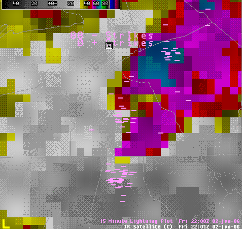
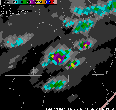
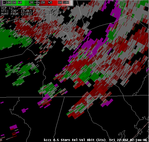
| Infrared Satellite Picture from 2203z (603pm EDT) with multiple storms over York County. | KCCX WSR-88D One Hour Precipitation Estimate from 2105z through 2205z for York County. Note the yellow colors inside the purples, indicating possibly over two inches of rain in just one hour! These estimates were deemed very accurate, as very little hail was reported from these storms, and the precipitation algorithm setting that was incorrect the day before (the 1st) had been corrected by NWS CTP Staff. Again, this area received torrential rains in one hour (then additional rain later), with a well-corroborated rain gage report from a storm spotter in the area of 2.5 inches of rain in just an hour and a half. | KCCX WSR-88D Storm Relative Motion from 2203z. Note the red and green colors right next to each other (a velocity couplet) over South-Central York County indicating a mesocyclone (mid-level cyclonic rotation) in the thunderstorm cell. This cell is the one that produced the wind damage, and it also contributed to the flooding. The mesocyclone was an indication of the very strong updraft in the storm. People often ask us - "What is the advantage of a Doppler Radar?" Well - this is it! We (as radar operators) can see the storm-scale rotation, and make inferences about the strength and severity of the individual storm cells. Not every storm has the potential to make wind damage and hail, and the doppler radar gives us the ability to infer more about the storm from it's structure than we could with only reflectivity. |
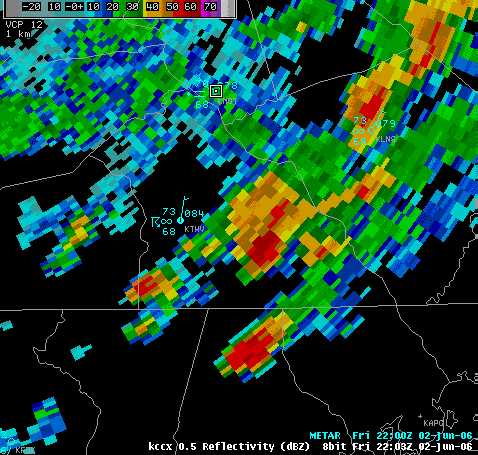
KCCX WSR-88D Reflectivity from 2203z. This is the same time and view of the SRM picture immediately above. Note the strong reflectivities, and the sharp gradient on the southeastern side of the cell. This is sometimes a sign of rotation and a mesocyclone, and corresponds very well with the SRM pic above. |
Storm Reports
..REMARKS..
0603 PM HEAVY RAIN SEVEN VALLEYS 39.85N 76.77W
06/02/2006 M2.50 INCH YORK PA TRAINED SPOTTER
2.5 INCHES IN HALF AN HOUR FROM 530 PM TO 6 PM.
0616 PM TSTM WND DMG 5 NW STEWARTSTOWN 39.80N 76.66W
06/02/2006 YORK PA LAW ENFORCEMENT
TREES AND WIRES DOWN IN EAST HOPEWELL TWP
0621 PM TSTM WND DMG LOGANVILLE 39.86N 76.71W
06/02/2006 YORK PA PUBLIC
TREES DOWN.
0630 PM FLOOD WINDSOR 39.92N 76.58W
06/02/2006 YORK PA LAW ENFORCEMENT
FLOODING CLOSED A PORTION OF WINDSOR ROAD
0835 PM FLASH FLOOD 10 S YORK 39.82N 76.73W
06/02/2006 YORK PA LAW ENFORCEMENT
MANY ROADS CLOSED ACROSS SOUTHERN HALF OF YORK COUNTY DUE
TO HIGH WATER.
0841 PM FLASH FLOOD 5 NE GLEN ROCK 39.84N 76.66W
06/02/2006 YORK PA LAW ENFORCEMENT
1 FOOT OF WATER STOPPING TRAFFIC ON INTERSTATE 83
SOUTHBOUND NEAR THE GLEN ROCK EXIT.
&&
$$
MMD
 |
Media use of NWS Web News Stories is encouraged! Please acknowledge the NWS as the source of any news information accessed from this site. |
|


 Send Us a Report