Overview
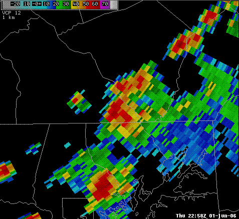
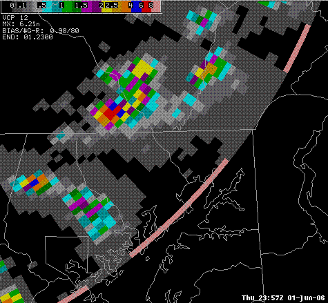
After being spared for the most part over the last two days of thunderstorms that stayed mainly over the higher-terrain of Central PA, York County saw thunderstorms erupt in the afternoon that repeatedly developed over the same spot in southeastern York County near the towns of Fawn Grove and Brogue. This same area had been hit by torrential rains and flash flooding back in Mid June of 2003!
 |
 |
| Reflectivity from 2258z (658pm EDT) with a nearly stationary thunderstorm over extreme southeast York County, PA. This storm produced over 5 inches of rain, and flash flooding in an area that got hit by flash flooding just a few years ago. | KCCX WSR-88D Three Hour Precipitation Estimate from 2000z through 2300z for Southeastern York County. Note the red colors indicating possibly over six inches of rain in three hours! These estimates were deemed to be too high, as they were most likely contaminated by hail, and a KCCX precipitation-algorithm setting that was incorrect. But, this does help to pinpoint the area of greatest rainfall, which is exactly where the flash flooding occurred. |
Storm Reports
000
NWUS51 KCTP 021443
LSRCTP
PRELIMINARY LOCAL STORM REPORT...SUMMARY
NATIONAL WEATHER SERVICE STATE COLLEGE PA
1043 AM EDT FRI JUN 02 2006
..TIME... ...EVENT... ...CITY LOCATION... ...LAT.LON...
..DATE... ....MAG.... ..COUNTY LOCATION..ST.. ...SOURCE....
..REMARKS..
0413 PM TSTM WND DMG POTTSVILLE 40.68N 76.21W
06/01/2006 SCHUYLKILL PA EMERGENCY MNGR
TREES DOWN
0651 PM FLASH FLOOD 4 NE FAWN GROVE 39.77N 76.40W
06/01/2006 YORK PA EMERGENCY MNGR
INTERSECTION OF ROUTE 425 AND NACE ROAD CLOSED DUE TO
FLOODING
0714 PM FLASH FLOOD 5 NE FAWN GROVE 39.78N 76.38W
06/01/2006 YORK PA EMERGENCY MNGR
WOODBINE ROAD CLOSED DUE TO FLOODING
&&
$$
VGC
 |
Media use of NWS Web News Stories is encouraged! Please acknowledge the NWS as the source of any news information accessed from this site. |
 |