A Pacific storm system will continue to bring low elevation rain and mountain snow to much of the West through Wednesday, with heavy mountain snow expected in the higher elevations of the Sierra Nevada. This system will also bring strong winds to the Intermountain West, Rockies, and Plains, which will create Critical fire weather conditions for the High Plains. Read More >
Overview
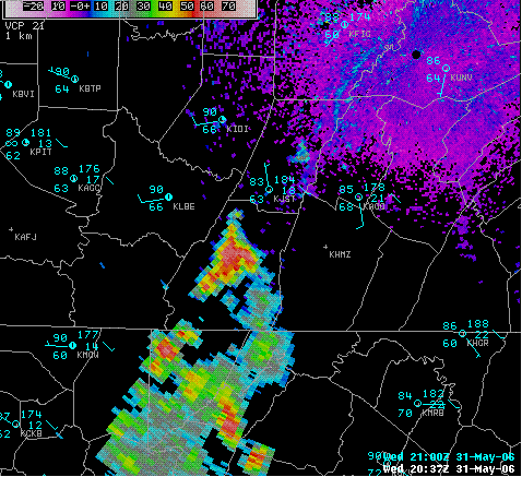
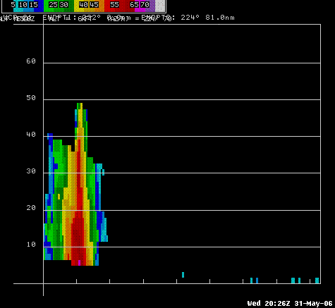
Much like the previous day, the afternoon of May 31st, 2006 brought abnormally hot temperatures in the mid to upper 80s to Central PA. The hot weather combined with increasing low level moisture and the rugged terrain of Central PA to produce a second day of tall and damaging pulse thunderstorms. A PULSE thunderstorm is one that typically grows up due to a point source of heating and lift, and collapses when it moves away from that source of lift. Pulse thunderstorms may pulse up and collapse many times, and may move very slowly. This means they are threats for flash flooding as well as hail and, more rarely, wind damage. If a pulse thunderstorm makes damaging wind gusts, it is usually because the storm has so much water held aloft and the cooling from the evaporation in the mid layers of the atmosphere is so great that the cooled air rushes down to the ground with great velocity. That was the case on this May 31st as well, which is a banner day for severe weather in Central PA. May 31st is the anniversary of the Great Johnstown Flood of 1889, and two devastating tornado outbreaks in 1985 and 1998. A handful of storms made large hail, and flash flooding, including mudslides this May 31st. The mudslides were most likely caused by the second day of heavy rain for many local spots in the higher elevations of PA, and may have been made worse by wildfires that burned up rural areas earlier during the very dry spring of 2006.
 |
 |
| Reflectivity from 2037z (437pm EDT) with terrain- and heat-induced pulse thunderstorm over Somerset County. This storm produced large hail and torrential rain. | Reflectivity Cross Section of the storm over Somerset County that made very large hail and heavy rain. Note the high (red) reflectivities held aloft up to 40 thousand feet! |
Storm Reports
000
NWUS51 KCTP 021443
LSRCTP
PRELIMINARY LOCAL STORM REPORT...SUMMARY
NATIONAL WEATHER SERVICE STATE COLLEGE PA
1043 AM EDT FRI JUN 02 2006
..TIME... ...EVENT... ...CITY LOCATION... ...LAT.LON...
..DATE... ....MAG.... ..COUNTY LOCATION..ST.. ...SOURCE....
..REMARKS..
0442 PM HAIL CONFLUENCE 39.81N 79.35W
05/31/2006 E0.88 INCH SOMERSET PA PUBLIC
NICKLE SIZED HAIL REPORTED ALONG SOMERSET COUNTY LINE
NEAR CONFLUENCE.
0530 PM HEAVY RAIN SOMERSET 40.01N 79.08W
05/31/2006 E0.00 INCH SOMERSET PA LAW ENFORCEMENT
ESTIMATED 2 TO 4 INCHES PER HOUR OVER THE LAST HOUR IN
SOMERSET CAUSING BASEMENTS TO FLOOD AND ROAD CLOSURES.
ALSO REPORTED...MULTIPLE TREES DOWN IN TOWN.
0530 PM HEAVY RAIN N SOMERSET 40.01N 79.08W
05/31/2006 M0.00 INCH SOMERSET PA TRAINED SPOTTER
2.25 INCHES OF RAINFALL IN 1 HOUR 15 MINUTES. MAX HAIL
SIZE DURRING EVENT 1/4 INCH DIAMETER.
0535 PM HAIL OGLETOWN 40.19N 78.70W
05/31/2006 E1.00 INCH SOMERSET PA PUBLIC
1 INCH DIAMETER HAIL REPORTED BY PUBLIC
0600 PM FLASH FLOOD LILLY 40.42N 78.62W
05/31/2006 CAMBRIA PA LAW ENFORCEMENT
ROCK SLIDE REPORTED ON PORTIONS OF ROUTE 53. BASEMENTS IN
NEARBY LILLY FLOODED.
0655 PM HAIL 4 ENE WELLSBORO 41.77N 77.23W
05/31/2006 M0.88 INCH TIOGA PA TRAINED SPOTTER
SPOTTER REPORTS NICKEL SIZED HAIL.
0730 PM FLOOD 3 W LILLY 40.42N 78.68W
05/31/2006 CAMBRIA PA EMERGENCY MNGR
FLOODING ALONG LITTLE CONEMAUGH DAMAGED ROADWAYS AND
BERM. ADDITIONALLY...APPROXIMATLY 30 BASEMENTS FLOODED
BETWEEN THE LITTLE CONEMAUGH AND TOWN OF LILLY.
0806 PM FLASH FLOOD HYNER 41.30N 77.67W
05/31/2006 CLINTON PA LAW ENFORCEMENT
ROCKSLIDE AND TREES DOWN ON ROUTE 120 NEAR HYNER.
&&
$$
VGC
 |
Media use of NWS Web News Stories is encouraged! Please acknowledge the NWS as the source of any news information accessed from this site. |
 |