Overview
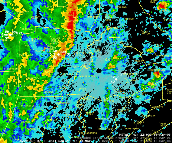
Unseasonably warm air for mid-March greeted Pennsylvanian's on the morning of the 13th, and a stong cold front quickly advanced through the midwest during the afternoon hours. Very strong winds only one to two thousand feet aloft lead to a day with lots of thunderstorms with gusty winds. A few of these bow-echo cells made damaging wind gusts of 60 mph or more. The best cell of the day moved in a long path from western PA (near Butler) thorough Clearfield County, Northern Clinton County and over to Sullivan County. It made wind damage most of the way along it's path. The Clearfield Lawrence County Airport reported a peak wind gust of 51 knots (59 mph). Trees were reported down in other parts of northern Clearfield County. More trees fell along Route 120 in Northern Clinton County, west of Renovo. Sporadic, light, tree damage occurred from this same storm cell as it move through Northern Lycoming County, and then pushed two trees onto Route 42 near Muncy Valley (in Sullivan County). Damage occurred from the same line of storms, but from other thunderstorm cells in Eastern Tioga County, near Covington, PA, where trees were blown down and a number of buildings damaged. A wind gust of 60 mph was estimated in Northern Dauphin County (near Millersburg), as well.
 |
 |
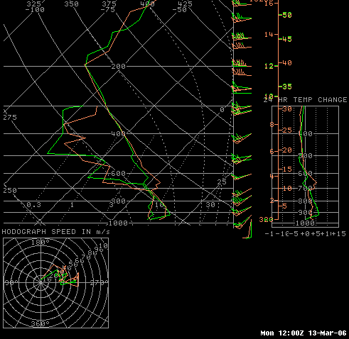 |
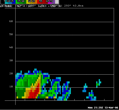
| Reflectivity from KCCX Around the time the 51 knot gust happened at KFIG (Clearfield Airport) | Reflectivity Cross Section (Vertical Slice) from KCCX as the storm blew down trees east of DuBois | Morning Atmospheric Soundings (balloon data) from Pittsburgh, PA and Wilmington, OH. |
Photos & Video
 |
 |
 |
 |
Storm Reports
PRELIMINARY LOCAL STORM REPORT...SUMMARY
NATIONAL WEATHER SERVICE STATE COLLEGE PA
747 PM EST MON MAR 13 2006
..TIME... ...EVENT... ...CITY LOCATION... ...LAT.LON...
..DATE... ....MAG.... ..COUNTY LOCATION..ST.. ...SOURCE....
..REMARKS..
0449 PM TSTM WND DMG ROCKTON 41.08N 78.66W
03/13/2006 CLEARFIELD PA EMERGENCY MNGR
NUMEROUS TREES DOWN
0454 PM TSTM WND GST CLEARFIELD 41.02N 78.44W
03/13/2006 M59 MPH CLEARFIELD PA OFFICIAL NWS OBS
51 KT WIND GUST REPORTED AT CLEARFIELD AIRPORT
0525 PM TSTM WND DMG WESTPORT 41.30N 77.84W
03/13/2006 CLINTON PA EMERGENCY MNGR
TWO TREES DOWN NEAR WESTPORT ON RTE 120.
0637 PM TSTM WND DMG 3 SE MUNCY VALLEY 41.32N 76.56W
03/13/2006 SULLIVAN PA EMERGENCY MNGR
POWER LINES DOWN ON RTE 42 IN DAVIDSON TWP.
0705 PM TSTM WND GST MILLERSBURG 40.54N 76.96W
03/13/2006 E60 MPH DAUPHIN PA PUBLIC
PUBLIC REPORT TO 911 CENTER
&&
$$
MMD
 |
Media use of NWS Web News Stories is encouraged! Please acknowledge the NWS as the source of any news information accessed from this site. |
 |