
Extremely critical fire weather conditions are expected to develop across the Great Basin and Southwest today, and exceptionally dry and windy conditions will promote rapid wildfire spread through the weekend. Scattered severe thunderstorms and heavy rain are possible across parts of the Ozark Plateau into lower Ohio Valley and parts of the northern Rockies into adjacent Great Plains. Read More >
Overview
|
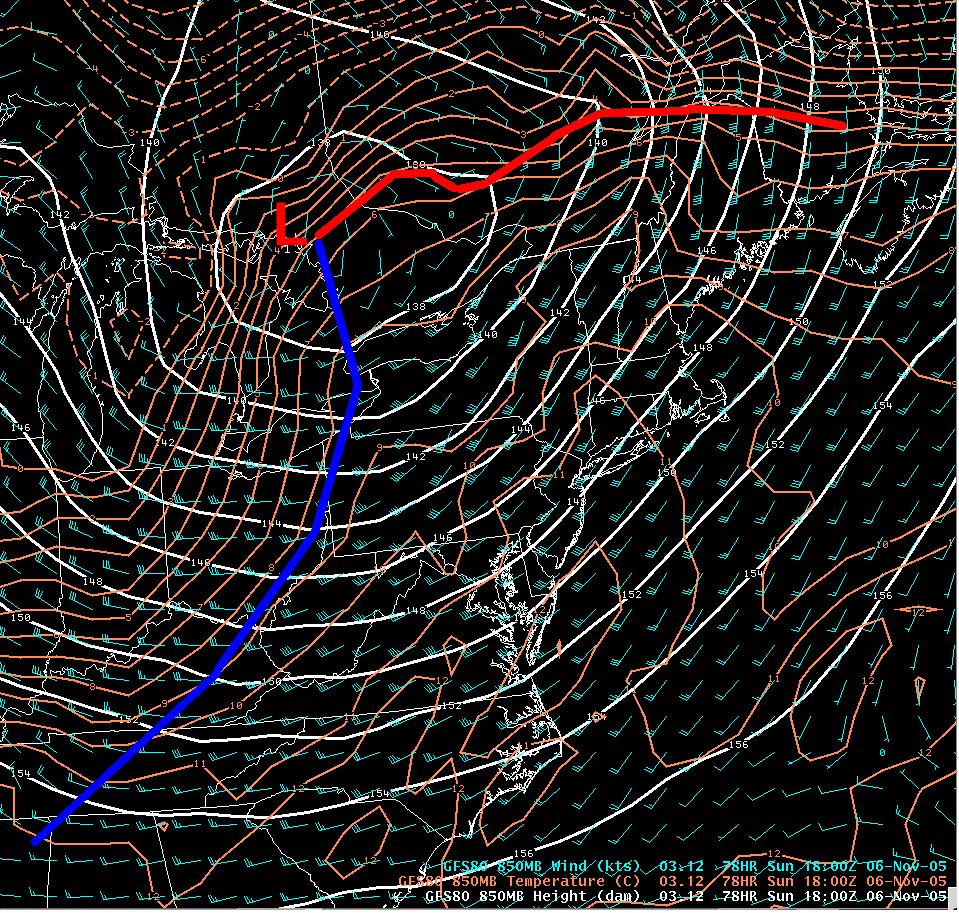
A cold front approached Pennsylvania from the west on Sunday, the 6th of November, and hit very mild air as it entered PA. This abnormally warm air for early November and the strong wind shear in the lowest 10 thousand feet of the atmosphere caused Severe Thunderstorms to develop during the middle of the day. |
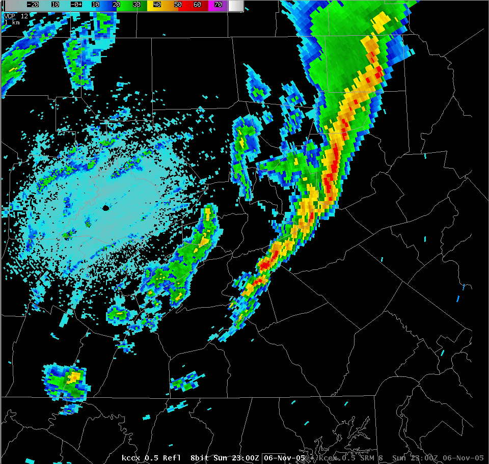 The storms produced widespread wind damage (mainly trees down and trees on wires) across all the of the northern half of Central PA, but the cells weakened as they moved into the Harrisburg area and the lower Susquehanna valley. A few hail reports were received, especially in eastern PA. This was one of the most widespread and damaging events of the year for Central PA. |
 |
 |
 |
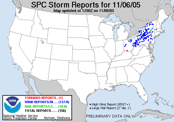
| SPC Reports | Surface Front Animation | Structure Damage |
Balloon Soundings
 |
 |
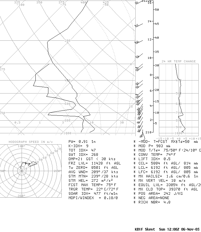
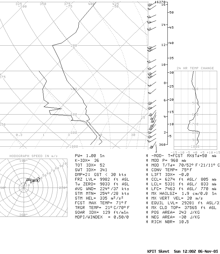
| 12 UTC 11/06 (7:00 am EST) Early morning - Atmosphere Primed and Ready Weak CAPE but Strong Shear |
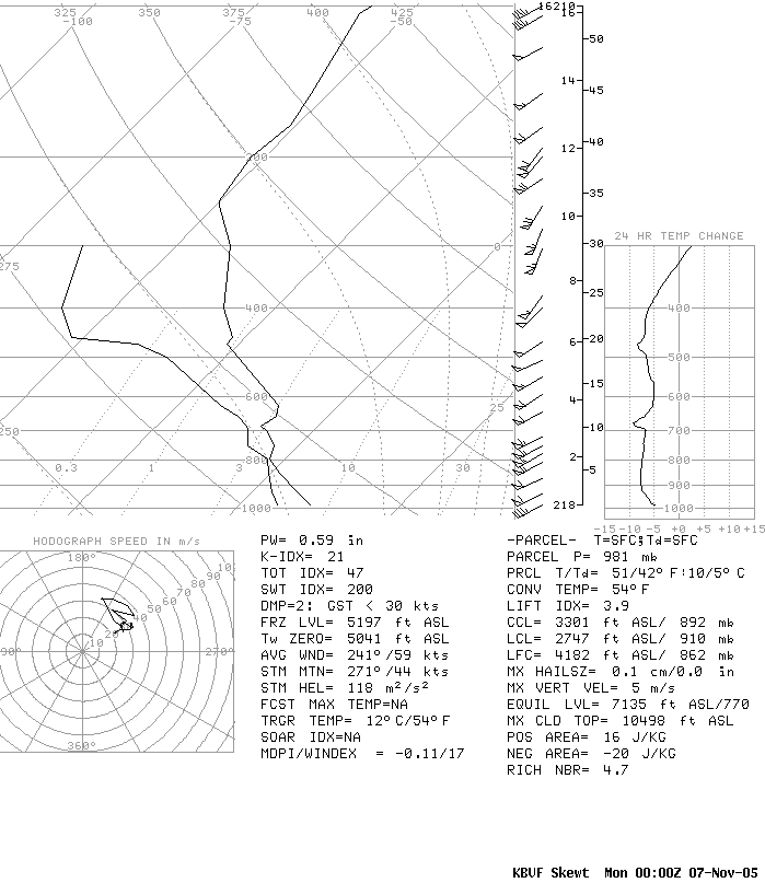
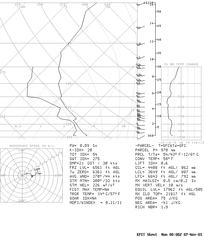
00 UTC 11/07 (7:00 pm EST) After the Front and Storms passed through |
 |
 |
| 12 UTC 11/06 (7:00 am EST) Early morning - Atmosphere Primed and Ready More Great Shear (see hodograph part |
00 UTC 11/07 (7:00 pm EST) After the Front and Storms passed through Note 50+ knot winds in lowest levels |
Photos & Video
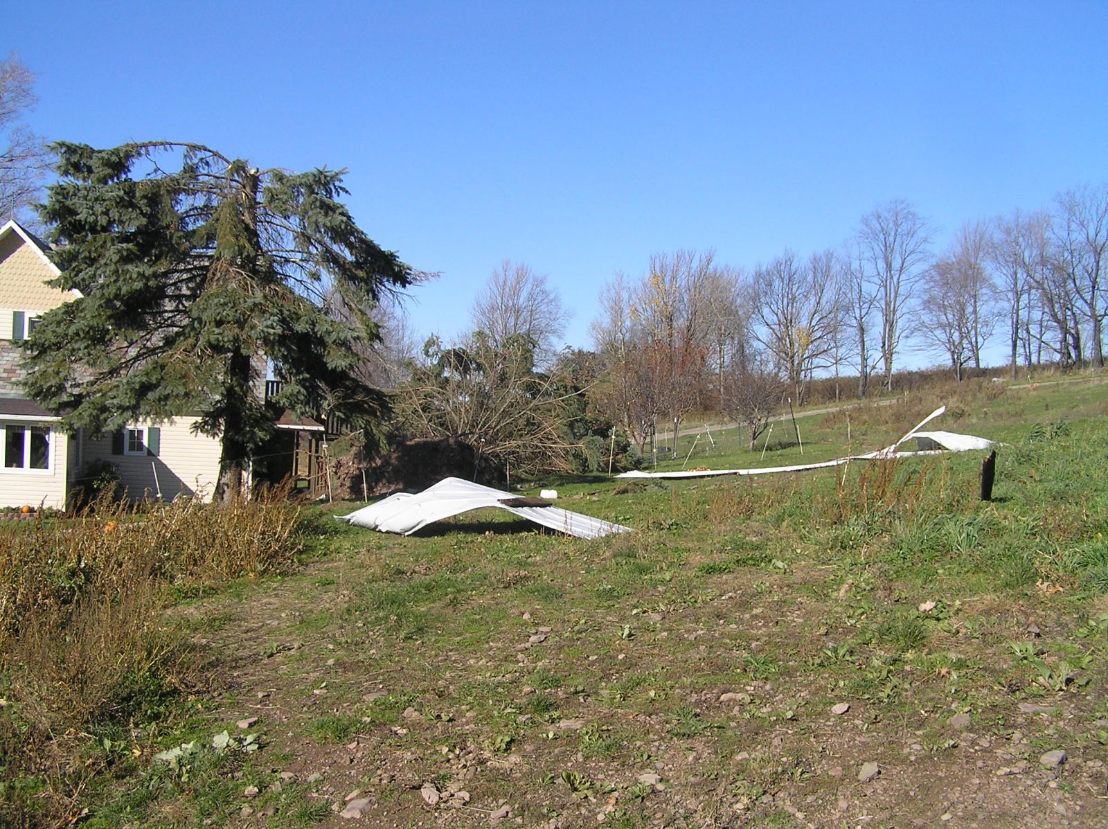
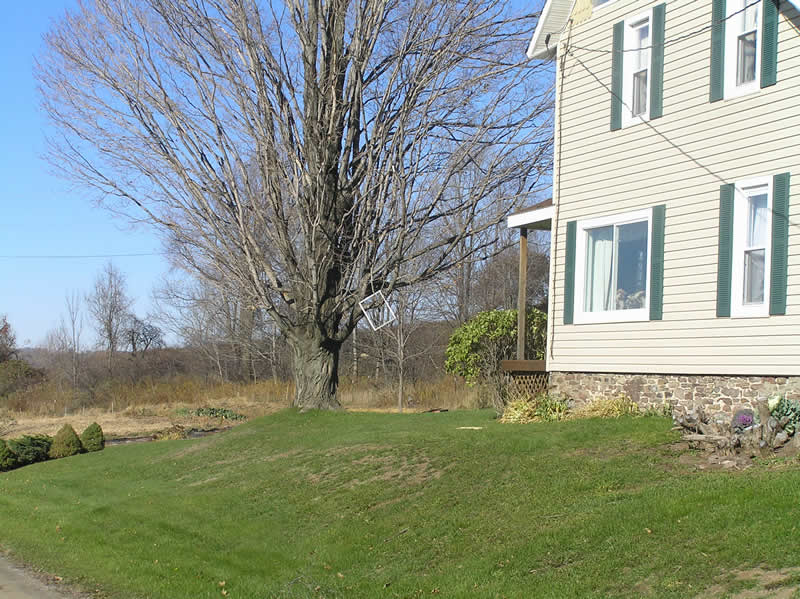
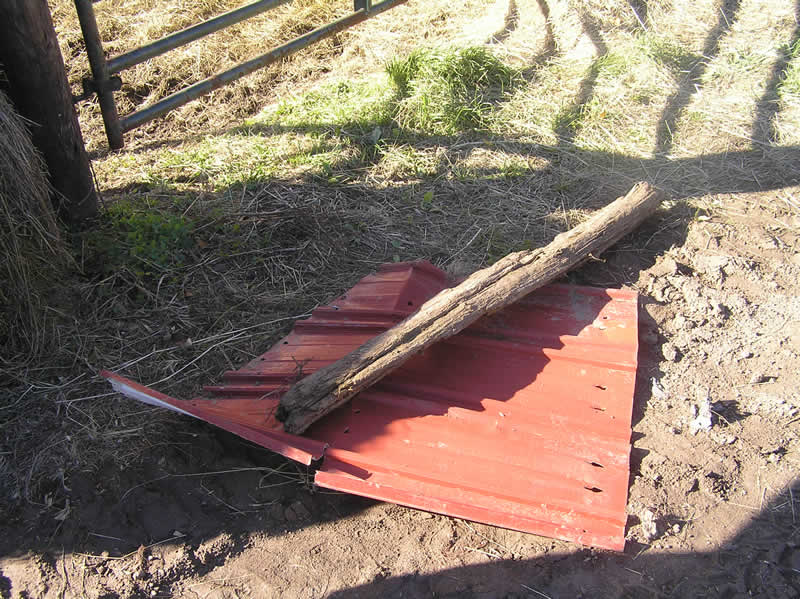
Damage Pictures from Jackson Summit in
Tioga County
 |
 |
|
 |
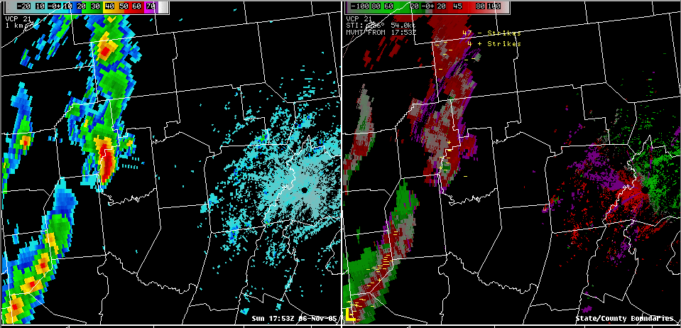
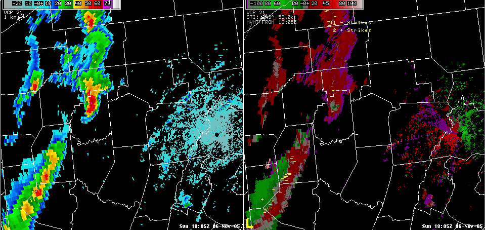
Radar
 |
 |
 |
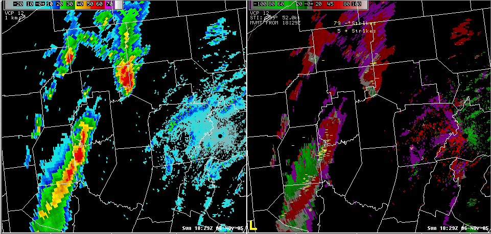 |
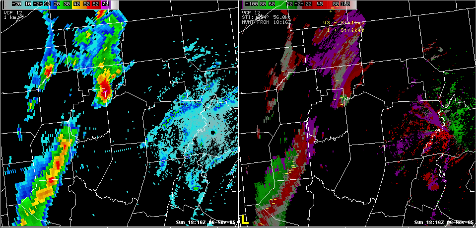
| 17:53 UTC (12:53 pm) | 18:05 UTC (1:05 pm) | 18:16 UTC (1:16 pm) | 18:29 UTC (1:29 pm) |
 |
 |
 |
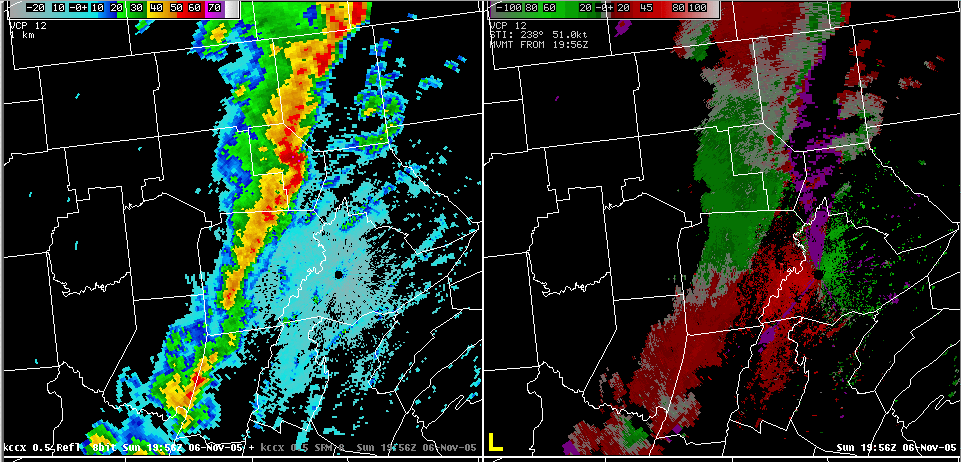 |
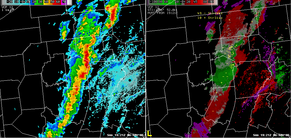
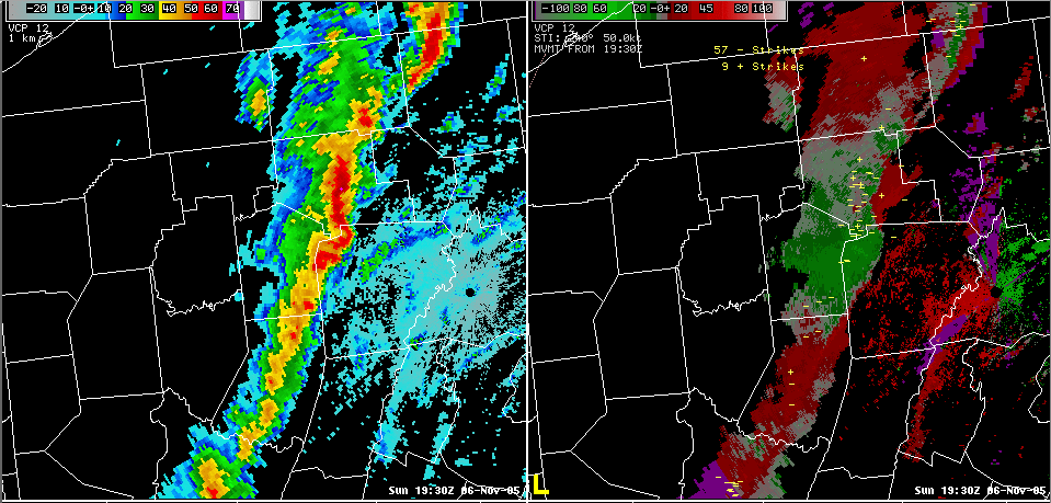
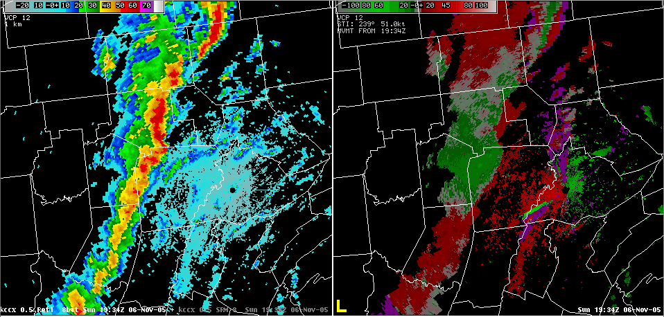
| 19:21 UTC (2:21 pm) | 19:30 UTC (2:30 pm) | 19:34 UTC (2:34 pm) | 19:56 UTC (2:56 pm) |
 |
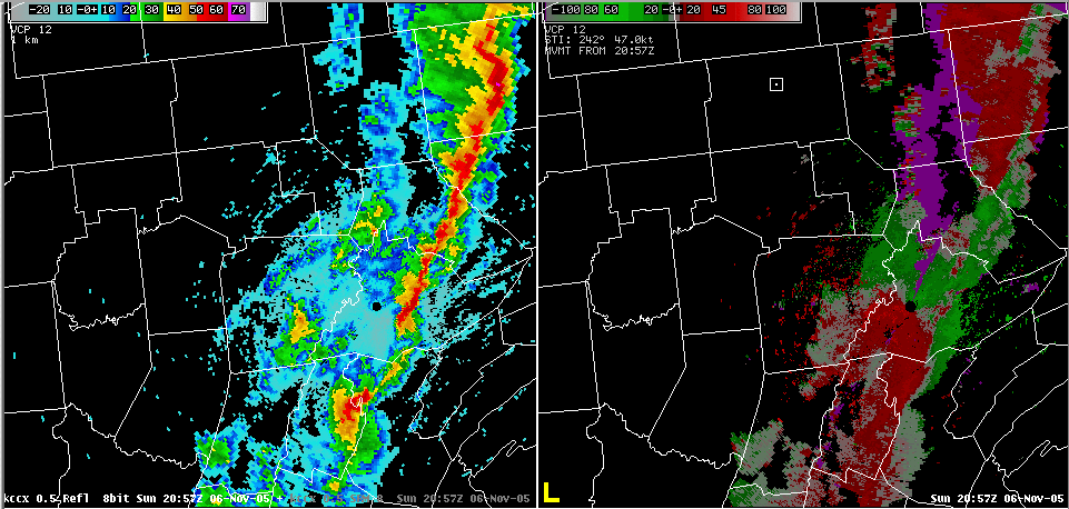 |
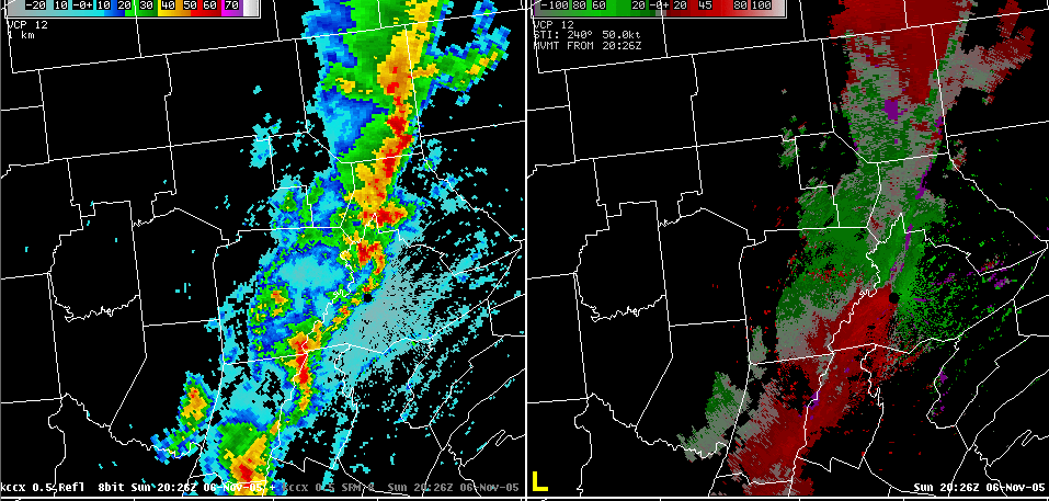
| 20:26 UTC (3:26 pm) | 20:57 UTC (3:57 pm) |
Storm Reports
|
Storm Damage Survey Results
PUBLIC INFORMATION STATEMENT NATIONAL WEATHER SERVICE STATE COLLEGE PA 535 PM EDT MON NOV 7 2005 ...DOWNBURST DAMAGE DISCOVERED IN TIOGA COUNTY... A SURVEY TEAM FROM THE NATIONAL WEATHER SERVICE AND THE TIOGA COUNTY EMERGENCY MANAGEMENT AGENCY SURVEYED DAMAGE FROM STORMS THAT OCCURRED YESTERDAY (SUN NOV 6) NEAR JACKSON SUMMIT. THE STORM KNOCKED DOWN SEVERAL TREES AS WELL AS REMOVED A BARN ROOF AND SIDING FROM A HOUSE. SOME OF THE TIN BAR ROOF WAS FOUND ABOUT 150 YARDS AWAY FROM THE BARN ITSELF. WINDS WERE ESTIMATED TO BE AROUND 60 TO 70 MPH AND IT APPEARS THE DAMAGE WAS FROM A DOWNBURST. THERE WAS NO EVIDENCE OF A TORNADIC STORM. DOWNBURST STORMS CAN BE JUST AS DANGEROUS AS TORNADIC STORMS. WIND SPEEDS IN DOWNBURST CAN REACH WELL ABOVE 100 MPH AND CAN DAMAGE OR DESTROY STRUCTURES. ANYTIME A SEVERE THUNDERSTORM OR TORNADO WARNING IS ISSUED...SEEK SHELTER IN A STURDY STRUCTURE AND BE BELOW GROUND IF POSSIBLE. $$ ONDREJIK/JUNG |
Preliminary Local Storm Report
from Sunday Evening
NWUS51 KCTP 070117
LSRCTP

PRELIMINARY LOCAL STORM REPORT...SUMMARY
NATIONAL WEATHER SERVICE STATE COLLEGE PA
816 PM EST SUN NOV 06 2005

..TIME...   ...EVENT...      ...CITY LOCATION...     ...LAT.LON...
..DATE...   ....MAG....      ..COUNTY LOCATION..ST.. ...SOURCE....
            ..REMARKS..

0220 PM     TSTM WND DMG     RIDGWAY                 41.43N 78.73W
11/06/2005                   ELK                PA   LAW ENFORCEMENT

            TREES AND WIRES DOWN COUNTYWIDE

0225 PM     TSTM WND DMG     PORT ALLEGANY           41.81N 78.28W
11/06/2005                   MCKEAN             PA   LAW ENFORCEMENT

            TREES/POWER LINES DOWN ON MAIN STREET

0238 PM     TSTM WND DMG     DUBOIS                  41.12N 78.76W
11/06/2005                   CLEARFIELD         PA   TRAINED SPOTTER

            TREES AND WIRES DOWN

0248 PM     TSTM WND DMG     PENFIELD                41.21N 78.60W
11/06/2005                   CLEARFIELD         PA   LAW ENFORCEMENT

            WIRES DOWN AND TREE ON STRUCTURE

0255 PM     TSTM WND DMG     COUDERSPORT             41.77N 78.01W
11/06/2005                   POTTER             PA   LAW ENFORCEMENT

            MULTIPLE TREES DOWN

0300 PM     TSTM WND DMG     EMPORIUM                41.51N 78.24W
11/06/2005                   CAMERON            PA   LAW ENFORCEMENT

            TREES DOWN ON ROADS CAUSING NUMEROUS ACCIDENTS

0310 PM     TSTM WND DMG     EMPORIUM                41.51N 78.24W
11/06/2005                   CAMERON            PA   TRAINED SPOTTER

            TREES DOWN AND ROADS CLOSED IN CAMERON COUNTY. ALSO HEARD
            OF SIMILAR DAMAGE IN ELK COUNTY.

0317 PM     TSTM WND DMG     COUDERSPORT             41.77N 78.01W
11/06/2005                   POTTER             PA   LAW ENFORCEMENT

            TREES DOWN

0319 PM     HAIL             HARRISON VALLEY         41.92N 77.67W
11/06/2005  1.00 INCH        POTTER             PA   LAW ENFORCEMENT

            HALF INCH TO ONE INCH SIZED HAIL

0330 PM     TSTM WND GST     GALETON                 41.73N 77.64W
11/06/2005  60 MPH           POTTER             PA   CO-OP OBSERVER

            60 MPH GUST AND PEA SIZE HAIL

0335 PM     TSTM WND DMG     BROCKPORT               41.27N 78.73W
11/06/2005                   ELK                PA   LAW ENFORCEMENT

            TREES AND WIRES DOWN

0339 PM     TSTM WND DMG     7 S EMPORIUM            41.41N 78.24W
11/06/2005                   CAMERON            PA   LAW ENFORCEMENT

            TREES AND WIRES DOWN NEAR CALEDONIA

0345 PM     TSTM WND DMG     TAMARACK                41.42N 77.85W
11/06/2005                   CLINTON            PA   LAW ENFORCEMENT

            TREES DOWN BLOCKING ONE LANE OF RT 144

0346 PM     TSTM WND DMG     HOLLIDAYSBURG           40.43N 78.39W
11/06/2005                   BLAIR              PA   LAW ENFORCEMENT

            TREES DOWN

0355 PM     TSTM WND DMG     DUNCANSVILLE            40.43N 78.43W
11/06/2005                   BLAIR              PA   LAW ENFORCEMENT

            TREES DOWN

0400 PM     TSTM WND DMG     WELLSBORO               41.75N 77.30W
11/06/2005                   TIOGA              PA   EMERGENCY MNGR

            ROOF PARTIALLY OFF THE AGWAY STORE

0401 PM     TSTM WND DMG     KNOXVILLE               41.96N 77.44W
11/06/2005                   TIOGA              PA   LAW ENFORCEMENT

            ROOF OFF BARN

0402 PM     HAIL             MANSFIELD               41.81N 77.08W
11/06/2005  0.88 INCH        TIOGA              PA   TRAINED SPOTTER

            HAIL COVERING GROUND

0403 PM     TSTM WND DMG     5 S WESTFIELD           41.85N 77.54W
11/06/2005                   TIOGA              PA   LAW ENFORCEMENT

            TREES DOWN NEAR SABINSVILLE

0404 PM     HAIL             MANSFIELD               41.81N 77.08W
11/06/2005  0.75 INCH        TIOGA              PA   TRAINED SPOTTER

            PENNY SIZE HAIL

0409 PM     TSTM WND DMG     BELLEFONTE              40.91N 77.77W
11/06/2005                   CENTRE             PA   LAW ENFORCEMENT

            TREES DOWN

0410 PM     TSTM WND DMG     HOLLIDAYSBURG           40.43N 78.39W
11/06/2005                   BLAIR              PA   LAW ENFORCEMENT

            TREES DOWN

0410 PM     TSTM WND DMG     HUNTINGDON              40.50N 78.01W
11/06/2005                   HUNTINGDON         PA   LAW ENFORCEMENT

            TREE LIMB ON VAN IN HUNTINGDON BORO

0415 PM     TSTM WND DMG     MILLERTON               41.98N 76.95W
11/06/2005                   TIOGA              PA   LAW ENFORCEMENT

            POSSIBLE TORNADO DAMAGE IN JACKSON TWP...MULTIPLE TREES
            DOWN...TWISTED DEBRIS

0415 PM     TSTM WND DMG     MANSFIELD               41.81N 77.08W
11/06/2005                   TIOGA              PA   LAW ENFORCEMENT

            TREES DOWN

0425 PM     TSTM WND DMG     WATERVILLE              41.32N 77.35W
11/06/2005                   LYCOMING           PA   LAW ENFORCEMENT

            MULTIPLE TREES DOWN IN PINE CREEK VALLEY

0430 PM     TSTM WND DMG     LAMAR                   41.01N 77.51W
11/06/2005                   CLINTON            PA   LAW ENFORCEMENT

            TREES DOWN

0430 PM     TSTM WND DMG     LEWISTOWN               40.60N 77.57W
11/06/2005                   MIFFLIN            PA   LAW ENFORCEMENT

            TREES DOWN ACROSS ALL OF MIFFLIN COUNTY

0440 PM     TSTM WND DMG     5 NE LOCK HAVEN         41.19N 77.39W
11/06/2005                   CLINTON            PA   LAW ENFORCEMENT

            TREES DOWN IN DUNSTABLE TWP

0440 PM     TSTM WND DMG     WILLIAMSPORT            41.24N 77.02W
11/06/2005                   LYCOMING           PA   LAW ENFORCEMENT

            TREES DOWN

0455 PM     TSTM WND DMG     MIFFLINBURG             40.92N 77.05W
11/06/2005                   UNION              PA   LAW ENFORCEMENT

            WIRES DOWN

0459 PM     TSTM WND DMG     WILLIAMSPORT            41.24N 77.02W
11/06/2005                   LYCOMING           PA   LAW ENFORCEMENT

            TREES DOWN

0500 PM     TSTM WND DMG     5 W LEWISBURG           40.96N 76.99W
11/06/2005                   UNION              PA   LAW ENFORCEMENT

            TREES ON WIRES

0510 PM     TSTM WND DMG     HUGHESVILLE             41.24N 76.73W
11/06/2005                   LYCOMING           PA   LAW ENFORCEMENT

            TREES DOWN AND METAL ROOFING ON WIRES

0510 PM     TSTM WND DMG     MILTON                  41.01N 76.85W
11/06/2005                   NORTHUMBERLAND     PA   EMERGENCY MNGR

            TREES ON HOUSE...ALSO TREES AND WIRES DOWN AT ANOTHER
            LOCATION IN MILTON

0516 PM     TSTM WND DMG     LAPORTE                 41.42N 76.49W
11/06/2005                   SULLIVAN           PA   LAW ENFORCEMENT

            TREES DOWN ON RT 154

0519 PM     TSTM WND DMG     5 W DUSHORE             41.53N 76.50W
11/06/2005                   SULLIVAN           PA   LAW ENFORCEMENT

            TREES ON CABIN CAUSED ROOF COLLAPSE IN CHERRY MILLS

0532 PM     TSTM WND DMG     7 N DANVILLE            41.06N 76.61W
11/06/2005                   MONTOUR            PA   LAW ENFORCEMENT

            TREES ON WIRES IN TWO LOCATIONS IN VALLEY TWP


&&

$$

MMD
 |
Media use of NWS Web News Stories is encouraged! Please acknowledge the NWS as the source of any news information accessed from this site. |
|


 Send Us a Report