Overview
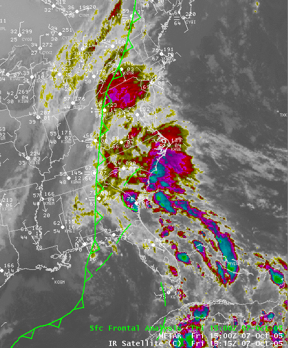
A cold front approached Pennsylvania from the northwest on Friday, the 7th of October, while a plume of deep tropical moisture flowed up into the mid-atlantic from the east. This tropical moisture and the circulation that accompanied it were the remnants of once-Tropical Storm Tammy.
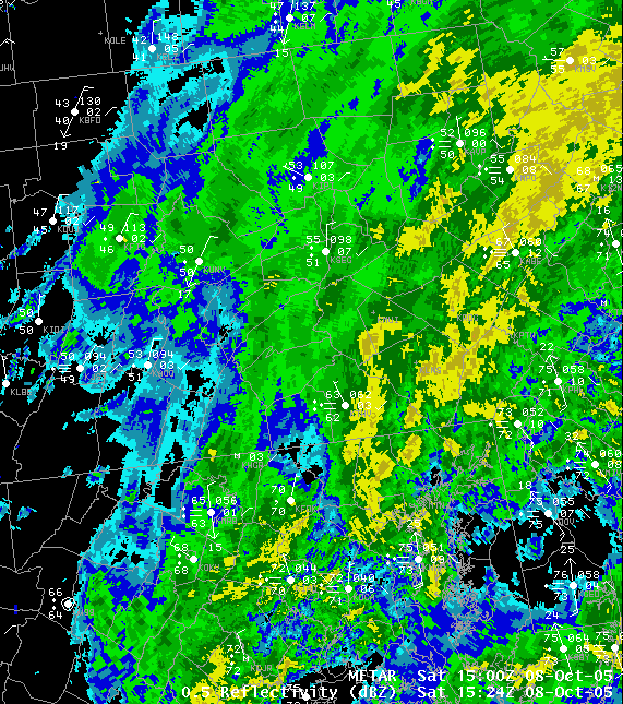
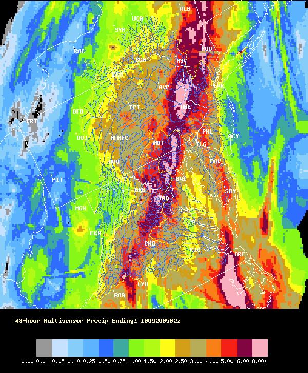
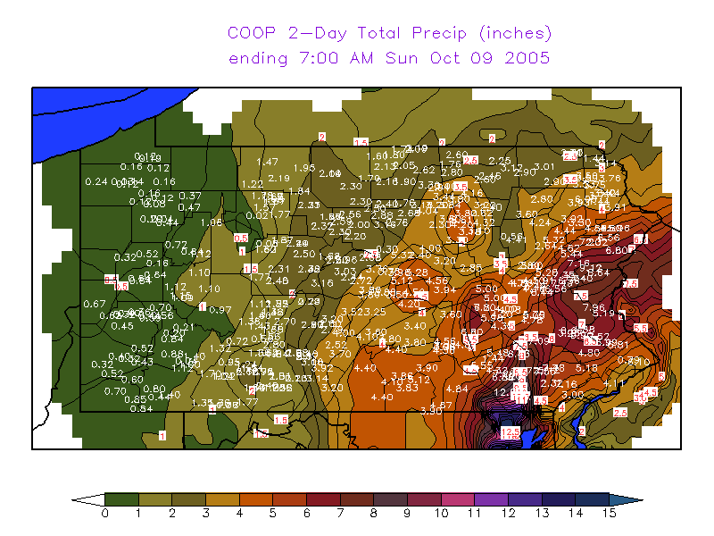
Heavy rain was the result. Amounts approached or exceeded 6 inches in places to the east of the Susquehanna River, with the heaviest totals near Lancaster, PA - as a widespread 8 to 12 inches of rain fell there. The rest of Central PA had 2-5 inches of rain. (See pictures below).
Generally, only Minor Flooding of smaller creeks and streams happened, as the area had been very dry for the entire summer. The dry antecedent conditions helped to keep the flooding from becoming worse in most areas. However, Major Flooding occurred in Lancaster County, where many roads were closed due to high water for as much as an entire day, and many homes and businesses had water damage.
 |
 |
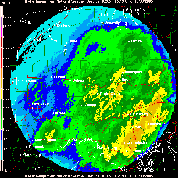 |
| Infrared Sat Pic from the 7th, with cold front overlaid. (Former) TS Tammy circulation over GA/SC. | Radar Reflectivity Mosaic from 1124 am EDT (1524 UTC) showing heavy rain in Eastern PA | KCCX Rainfall Estimate of Storm Total Rainfall |
 |
 |
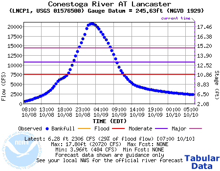 |
| 48-hour MutiSensor Precipitation Estimate from MARFC | 48 Hour Precip Totals (10-7-2005 7am thru 10-9-2005 7am) from co-operative observer reports and automated gages | Hydrograph of River Stage for the Conestoga River at Lancaster, crested at 17.8 feet (Major Flooding) 3am EDT 10/9/2005 |
Storm Reports
NWUS51 KCTP 082157
LSRCTP
PRELIMINARY LOCAL STORM REPORT...SUMMARY
NATIONAL WEATHER SERVICE STATE COLLEGE PA
333 PM EDT SAT OCT 08 2005
..TIME... ...EVENT... ...CITY LOCATION... ...LAT.LON...
..DATE... ....MAG.... ..COUNTY LOCATION..ST.. ...SOURCE....
..REMARKS..
0756 AM FLOOD COLUMBIA 40.03N 76.50W
10/08/2005 LANCASTER PA TRAINED SPOTTER
*** 1 FATAL *** SINGLE VEHICLE ACCIDENT RESULTED IN CAR
OVERTURNED IN STREAM. ONE FATALITY OCCURRED.
0830 AM FLOOD CHRISTIANA 39.95N 76.00W
10/08/2005 LANCASTER PA EMERGENCY MNGR
2 WATER RESCUES NEAR CHRISTIANA THIS MORNING.
0900 AM FLOOD MILLERSVILLE 40.00N 76.35W
10/08/2005 LANCASTER PA TRAINED SPOTTER
MINOR FLOODING IN/NEAR THE MILLERSVILLE UNIV CAMPUS. 4.25
INCHES OF RAIN FOR THE EVENT SO FAR.
1100 AM FLOOD YORK 39.96N 76.73W
10/08/2005 YORK PA TRAINED SPOTTER
ROAD CLOSED DUE TO HIGH WATER.
1100 AM FLOOD MILLERSVILLE 40.00N 76.35W
10/08/2005 LANCASTER PA TRAINED SPOTTER
PEQUEA CREEK OUT OF BANKS AND APPROACHING RTE 741
1230 PM FLOOD LANCASTER 40.04N 76.30W
10/08/2005 LANCASTER PA EMERGENCY MNGR
WIDESPREAD FLOODING ACROSS THE ENTIRE COUNTY...
ESPECIALLY SOUTHERN HALF. 100S OF ROADS CLOSED. EM OFFICE
HAS ASKED FOR VOLUNTARY TRAVEL RESTRICTIONS. COMPARABLE
TO 1999 FLOODING FROM FLOYD.
0320 PM FLOOD MILLERSVILLE 40.00N 76.35W
10/08/2005 LANCASTER PA TRAINED SPOTTER
PEQUEA CREEK OUT OF ITS BANKS...CLOSE TO MOVING OVER
ROUTE 741 EAST OF MILLERSVILLE.
&&
$$
GAD
Rain Reports
NOUS41 KCTP 091549
PNSCTP
PAZ004>006-010>012-017>019-024>028-033>037-041-042-045-046-049>053-
056>059-063>066-100345-
PUBLIC INFORMATION STATEMENT
SPOTTER REPORTS
NATIONAL WEATHER SERVICE STATE COLLEGE PA
1150 AM EDT SUN OCT 9 2005
THE FOLLOWING ARE UNOFFICIAL STORM TOTAL OBSERVATIONS TAKEN DURING
THE PAST 72 HOURS FOR THE STORM THAT AFFECTED OUR REGION.
APPRECIATION IS EXTENDED TO HIGHWAY DEPARTMENTS...COOPERATIVE
OBSERVERS...SKYWARN SPOTTERS AND MEDIA FOR THESE REPORTS. THIS
SUMMARY IS ALSO AVAILABLE ON OUR HOME PAGE AT WEATHER.GOV/CTP
********************STORM TOTAL RAINFALL********************
LOCATION STORM TOTAL TIME/DATE COMMENTS
RAINFALL OF
(INCHES) MEASUREMENT
PENNSYLVANIA
...ADAMS COUNTY...
BIGLERVILLE 4.03 704 AM 10/8
ORRTANNA 3.15 530 PM 10/7
...BEDFORD COUNTY...
SAXTON 3.17 700 AM 10/9
BUFFALO MILLS 2.80 700 AM 10/9
WOLFSBURG 2.63 700 AM 10/9
EVERETT 2.33 700 AM 10/9
...BLAIR COUNTY...
TYRONE 3.02 700 AM 10/9
WILLIAMSBURG 2.95 700 AM 10/9
ALTOONA 2.46 700 AM 10/8
...CAMBRIA COUNTY...
PRINCE GALLITZIN 1.85 700 AM 10/9
EBENSBURG 1.53 700 AM 10/9
...CAMERON COUNTY...
SINNEMAHONING 2.43 700 AM 10/9
EMPORIUM 2.33 700 AM 10/8
...CENTRE COUNTY...
STATE COLLEGE 2.89 700 AM 10/8
CLARENCE 2.60 700 AM 10/8
PHILIPSBURG 2.05 700 AM 10/9
...CLEARFIELD COUNTY...
GRAMPIAN 2.06 700 AM 10/8
...CLINTON COUNTY...
LOCK HAVEN 3.04 700 AM 10/9
RENOVO 2.17 600 AM 10/9
...CUMBERLAND COUNTY...
SHIREMANSTOWN 4.00 700 AM 10/8
PINE GROVE FURNACE 3.86 700 AM 10/9
...DAUPHIN COUNTY...
DEHART DAM 6.95 700 AM 10/9
HARRISBURG 5.07 700 AM 10/9
HERSHEY 4.87 700 AM 10/9
...FRANKLIN COUNTY...
UPPER STRASBURG 5.78 700 AM 10/9
SOUTH MOUNTAIN 4.78 700 AM 10/9
CHAMBERSBURG 3.50 500 PM 10/7
GREENCASTLE 3.10 700 AM 10/8
...HUNTINGDON COUNTY...
HUNTINGDON 3.61 700 AM 10/9
...LANCASTER COUNTY...
NEW HOLLAND 10.72 700 AM 10/9
HOLTWOOD 8.73 700 AM 10/9
LANCASTER 7.37 700 AM 10/9
SAFE HARBOR 7.16 700 AM 10/9
...LYCOMING COUNTY...
WILLIAMSPORT 3.12 700 AM 10/9
...MCKEAN COUNTY...
CLERMONT 2.19 700 AM 10/9
KANE 1.22 705 AM 10/8
...MIFFLIN COUNTY...
LEWISTOWN 3.39 700 AM 10/8
...MONTOUR COUNTY...
DANVILLE 2.85 700 AM 10/9
...NORTHUMBERLAND COUNTY...
SUNBURY 2.84 700 AM 10/8
NORTHUMBERLAND 2.65 1100 PM 10/7
...POTTER COUNTY...
COUDERSPORT 2.10 700 AM 10/9
...SCHUYLKILL COUNTY...
PINE GROVE 6.06 700 AM 10/9
MAHANOY CITY 4.76 700 AM 10/9
...SNYDER COUNTY...
SELINSGROVE 3.96 700 AM 10/9
...SOMERSET COUNTY...
GLENCOE 2.41 700 AM 10/9
LAUREL SUMMIT 1.80 700 AM 10/9
CONFLUENCE 1.53 700 AM 10/9
MEYERSDALE 1.53 700 AM 10/9
SOMERSET 1.51 700 AM 10/9
...SULLIVAN COUNTY...
LAPORTE 3.06 700 AM 10/9
...TIOGA COUNTY...
SABINSVILLE 2.13 700 AM 10/9
WELLSBORO 2.09 700 AM 10/9
...UNION COUNTY...
LEWISBURG 3.20 700 AM 10/9
...YORK COUNTY...
HANOVER 5.53 700 AM 10/9
YORK HAVEN 5.43 700 AM 10/9
$$
CRUZ
 |
Media use of NWS Web News Stories is encouraged! Please acknowledge the NWS as the source of any news information accessed from this site. |
 |