Overview
|
In the early morning of September 29th, a cold front was racing eastward toward Pennsylvania at 60 to 70 miles per hour. A line of strong thunderstorms formed in the high-shear environment that was present over the western third of the state. Severe wind gusts and damage occurred as the cold front and the thunderstorms blasted across Central Pennsylvania between 4AM and 8AM. The winds weakened, as did the thunderstorms, just after daybreak over Eastern PA.
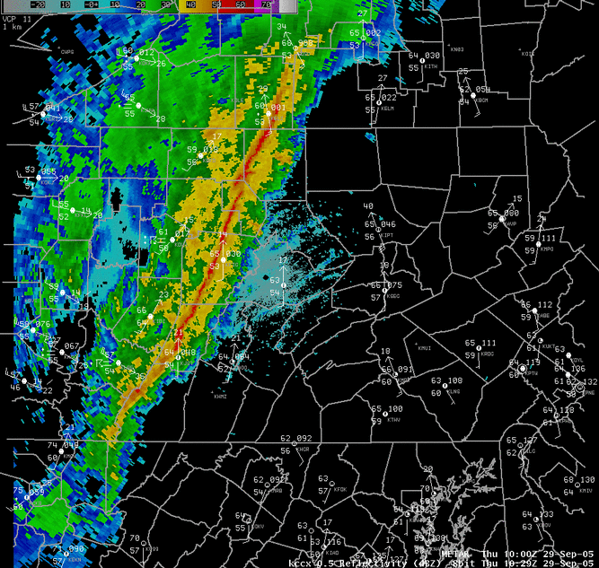
Narrow Cold Frontal Rainbands This case was a good example of what is termed a Narrow Cold-Frontal Rainband (NCFR, NCFRB). CTP Science Officer, Richard Grumm, has done a great deal of work studying and trying to classify these events. These events are characterized by a strong cold front that moves rapidly from west to east, and makes damaging winds despite having limited instability, and little or no thunder associated with the winds. The narrow, focused nature of the precipitation along the cold front itself is what gives these events their name. In the above radar reflectivity picture, note how there is little precipitation away from the wind shift itself. While there was some thunder with this cold front passage, this one was certainly an unusual event for Central PA, as it happened in the middle to late nighttime hours (4-8AM EDT). Historically, during that time of the day, Pennsylvania receives very little severe weather. These events happen a few times every year, mainly in the autumn, when the cold air is starting to make headways into the southern latitudes, and there is still some instability from higher moisture and daytime heating lingering from summer. |
 KCCX Reflectivity and surface observation plot from 529 AM EDT (1029 UTC) |
Storm Reports
000
NWUS51 KCTP 291926
LSRCTP
PRELIMINARY LOCAL STORM REPORT...SUMMARY
NATIONAL WEATHER SERVICE STATE COLLEGE PA
325 PM EDT THU SEP 29 2005
..TIME... ...EVENT... ...CITY LOCATION... ...LAT.LON...
..DATE... ....MAG.... ..COUNTY LOCATION..ST.. ...SOURCE....
..REMARKS..
0527 AM TSTM WND DMG WARREN 41.84N 79.14W
09/29/2005 WARREN PA COUNTY OFFICIAL
REPORTS OF TREES DOWN THROUGHOUT COUNTY
0555 AM TSTM WND DMG BRADFORD 41.96N 78.64W
09/29/2005 MCKEAN PA COUNTY OFFICIAL
TREES AND WIRES DOWN
0605 AM TSTM WND DMG WILCOX 41.58N 78.68W
09/29/2005 ELK PA COUNTY OFFICIAL
TREES DOWN
0610 AM TSTM WND DMG WESTLINE 41.77N 78.75W
09/29/2005 MCKEAN PA COUNTY OFFICIAL
TREES DOWN ON WIRES
0615 AM TSTM WND DMG RIDGWAY 41.43N 78.73W
09/29/2005 ELK PA COUNTY OFFICIAL
TREES AND WIRES DOWN
0620 AM TSTM WND DMG SHINGLEHOUSE 41.97N 78.19W
09/29/2005 POTTER PA CO-OP OBSERVER
TREES DOWN AND POWER OUT
0627 AM TSTM WND DMG DUBOIS 41.12N 78.76W
09/29/2005 CLEARFIELD PA COUNTY OFFICIAL
TREES DOWN
0635 AM TSTM WND DMG JOHNSTOWN 40.33N 78.92W
09/29/2005 CAMBRIA PA COUNTY OFFICIAL
TREES DOWN THROUGHOUT THE COUNTY. TRAFFIC LIGHTS OUT IN
JOHNSTOWN.
0636 AM TSTM WND DMG EMPORIUM 41.51N 78.24W
09/29/2005 CAMERON PA COUNTY OFFICIAL
WIRES DOWN
0700 AM TSTM WND DMG SNOW SHOE 41.03N 77.95W
09/29/2005 CENTRE PA TRAINED SPOTTER
TREES DOWN IN AND AROUND SNOWSHOE AND CLARENCE. OTHER
TREES DOWN AROUND CENTRE COUNTY
0720 AM TSTM WND DMG 5 N SHADE GAP 40.25N 77.87W
09/29/2005 HUNTINGDON PA COUNTY OFFICIAL
TREES DOWN ALONG RTE 522 AND RTE 22 4 MILES FROM MILL
CREEK
0730 AM TSTM WND DMG BEECH CREEK 41.07N 77.59W
09/29/2005 CLINTON PA COUNTY OFFICIAL
TREES DOWN ON WIRES SPORADICALLY THROUGHOUT COUNTY
0730 AM TSTM WND DMG BEDFORD 40.01N 78.50W
09/29/2005 BEDFORD PA COUNTY OFFICIAL
TREES DOWN ON WIRES
0800 AM TSTM WND DMG WILLIAMSPORT 41.24N 77.02W
09/29/2005 LYCOMING PA TRAINED SPOTTER
TREES DOWN IN BRANDON PARK AND ANOTHER BLOCKING SHERIDAN
STREET.
0800 AM TSTM WND DMG LEWISTOWN 40.60N 77.57W
09/29/2005 MIFFLIN PA COUNTY OFFICIAL
TREES DOWN
&&
$$
 |
Media use of NWS Web News Stories is encouraged! Please acknowledge the NWS as the source of any news information accessed from this site. |
 |