Overview
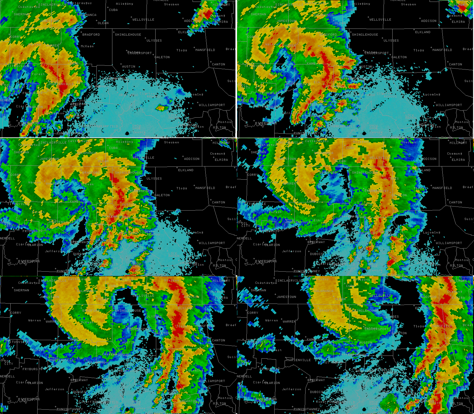
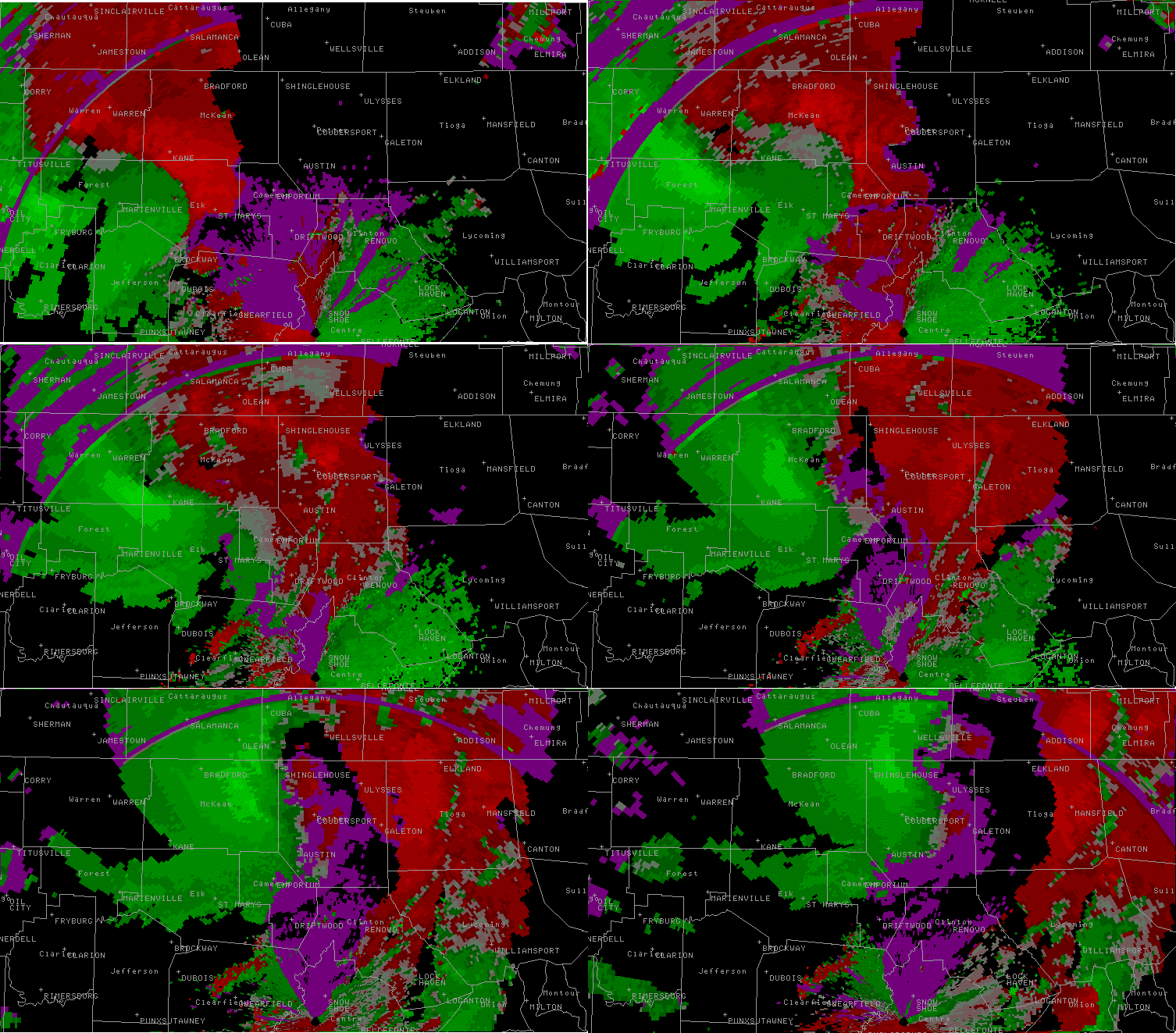
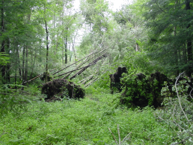
A devastating severe weather event struck Northern and Central Pennsylvania during the afternoon of July 21, 2003. The worst damage occurred over the Northern Pennsylvania Counties of McKean and Potter. Below are some preliminary images showing the damage, and two radar loops from the State College National Weather Service Doppler Radar. A more formal assessment of this event is underway. The Text of the Preliminary Storm Damage Survey Reports (issued as "Public Information Statements") from that day's more significant areas of damage follow after the picture links. A second day of severe weather followed on the 22nd, producing very large hail, and a weak tornado a few miles north of Harrisburg in Dauphin County. This Storm Damage Survey Report (and links to a few pictures of the damage) are also included here.
A second day of severe weather followed on the 22nd, producing very large hail, and a weak tornado a few miles north of Harrisburg in Dauphin County. This Storm Damage Survey Report (and links to a few pictures of the damage) are also included here.
 |
 |
 |
| Loop of Radar Reflectivity of the storms in progress as they swept across McKean and Potter counties. This loop ranges from 2:00 PM to 5:00 PM. |
Loop of Storm Relative Velocity of the storms in progress as they swept across McKean and Potter counties. This loop ranges from 2:00 PM to 5:00 PM. Green colors show wind flow towards the radar (located to the south of these images) and red colors show wind flow away from the radar. |
Landsville Tornado Daamge |
Tornadoes:
Tornado - ELLISBURG
POTTER COUNTY
| Date |
July 21st, 2003 |
| Time (Local) |
4 PM |
| EF Rating |
F3 |
| Est. Peak Winds |
160 MPH |
| Path Length |
2 1/2 MILES |
| Max Width |
200 YARDS |
| Injuries/Deaths |
-- |
|
Summary:
THE TORNADO FIRST TOUCHED DOWN ABOUT 2 MILES SOUTHWEST OF THE TOWN
OF ELLISBURG...WHERE IT DOWNED HUNDREDS OF TREES. THE TORNADO
CONTINUED TO THE NORTHEAST...WHERE IT HIT THE SMOKER FARM. THE BARN
AND HOUSE WERE COMPLETELY DESTROYED...AND ONE OF THREE SILOS WAS
TIPPED OVER. A SECOND HOME ON SMOKER ROAD WAS ALSO EXTENSIVELY
DAMAGED AND IS UNINHABITABLE. IN ADDITION...A CAR WAS PICKED UP AND
THROWN 600 YARDS. A FARM TRACTOR WAS LIFTED INTO THE TREES.

THE TORNADO PATH WAS 2 1/2 MILES LONG...WHILE THE WIDTH WAS ABOUT
200 YARDS. BASED ON THE DAMAGE...THE TORNADO WAS MAINLY AN F2...BUT
RATED AS A WEAK F3 AT ITS PEAK..WITH WINDS OF 160 MPH.
|
|
Straight Line Wind Damage
...STRAIGHT LINE WIND DAMAGE FOUND IN DAUPHIN COUNTY FROM JULY 21
STORM...

A TEAM FROM THE NATIONAL WEATHER SERVICE OFFICE IN STATE COLLEGE
SURVEYED DAMAGE AND INTERVIEWED RESIDENTS AND EMERGENCY MANAGEMENT
OFFICIALS IN DAUPHIN COUNTY TODAY. THE TEAM DETERMINED THAT DAMAGE
IN THE HARRISBURG AREA WAS CAUSED BY STRAIGHT LINE WINDS.

THE THUNDERSTORM PRODUCED WIND GUSTS OF 65 TO 70 MPH IN THE GREATER
HARRISBURG AREA...DOWNING 30 LARGE TREES AND AN ADDITIONAL NUMBER OF
SMALLER TREES. ABOUT 40 CARS WERE DAMAGED BY THE FALLING
TREES...ALONG WITH SOME DAMAGE TO HOMES. THE DAMAGING WIND OCCURRED
BETWEEN 1000 AND 1015 PM.
|
Tornado - KANE
McKean County
| Date |
July 21st, 2003 |
| Time (Local) |
3:15 - 3:30 PM |
| EF Rating |
F1 |
| Est. Peak Winds |
100 MPH |
| Path Length |
3 1/2 MILES |
| Max Width |
1/3 MILES |
| Injuries/Deaths |
0/0 |
|
Summary:
SURVEYED DAMAGE AND INTERVIEWED RESIDENTS AND EMERGENCY MANAGEMENT
OFFICIALS IN MCKEAN COUNTY TODAY. THE TEAM DETERMINED THAT AN F1
TORNADO DID TOUCH DOWN IN MCKEAN COUNTY BETWEEN 315 PM AND 330 PM
MONDAY AFTERNOON.

THE THUNDERSTORM WHICH SPAWNED THE TORNADO FIRST STARTED PRODUCING
DOWNBURST WIND DAMAGE 2 MILES WEST OF KANE. IT CONTINUED TO THE
NORTHEAST FOR 15 MILES...BEFORE THE TORNADO TOUCHED DOWN 1 MILE WEST
OF THE KINZUA VIADUCT IN A WOODED AREA. THE TORNADO CONTINUED
NORTHEAST...PRODUCING A DAMAGE PATH 3 1/2 MILES LONG...AND ABOUT 1/3
MILE WIDE. WINDS WERE ESTIMATED AT 100 MPH...WHICH CLASSIFIES THE
TORNADO AS AN F1 ON THE FUJITA SCALE. THE TORNADO CAUSED THE
COLLAPSE OF THE HISTORIC KINZUA VIADUCT BRIDGE. NINE OF THE 20
BRIDGE SUPPORTS WERE DESTROYED...LEADING TO THE COLLAPSE OF THE
BRIDGE. THOUSANDS OF TREES WERE ALSO DOWNED ALONG THE PATH OF THE
TORNADO.

THE TORNADO THEN LIFTED UP ABOUT 2 1/2 MILES NORTHEAST OF THE
BRIDGE. DOWNBURST WIND DAMAGE CONTINUED TO ABOUT 2 MILES NORTH OF
SMETHPORT...WHERE THE TORNADO ONCE AGAIN TOUCHED DOWN. THE TORNADO
CONTINUED ON A NORTH-NORTHEAST PATH UNTIL IT LIFTED AGAIN ABOUT 1
MILE NORTH OF FARMERS VALLEY...NEAR THE INTERSECTIONS OF ROUTES 46
AND 446. TOP WIND SPEEDS DURING THE SECOND TOUCHDOWN WERE ESTIMATED
AT 80 TO 90 MPH...AGAIN CLASSIFYING THE STORM AS AN F1 IN INTENSITY.
THE PATH OF THE SECOND TOUCHDOWN WAS ABOUT 3 MILES LONG...WITH A
WIDTH OF ABOUT 150 YARDS.

THIS SECOND TOUCHDOWN DAMAGED 2 BARNS...AND DESTROYED A THIRD. TWO
HOMES AND A CHURCH WERE ALSO DAMAGED. NO INJURIES OR DEATHS WERE
REPORTED.
|
|
Tornado - LAIRDSVILLE
LYCOMING COUNTY
| Date |
July 21st, 2003 |
| Time (Local) |
5:30 PM |
| EF Rating |
F1 |
| Est. Peak Winds |
90 MPH |
| Path Length |
5 MILES |
| Max Width |
1/2 MILE |
| Injuries/Deaths |
-- |
|
Summary:
A TEAM FROM THE NATIONAL WEATHER SERVICE OFFICE IN STATE COLLEGE
SURVEYED DAMAGE AND INTERVIEWED RESIDENTS AND EMERGENCY MANAGEMENT
OFFICIALS IN LYCOMING COUNTY TODAY. THE TEAM DETERMINED THAT AN F1
TORNADO DID TOUCH DOWN IN LYCOMING COUNTY ABOUT 530 PM MONDAY
AFTERNOON.

THE TORNADO FIRST TOUCHED DOWN ON FUNSTON ROAD IN LAIRDSVILLE WHERE
IT DID MOST OF ITS DAMAGE...TEARING A ROOF OFF A BARN AND CAUSING
MINOR DAMAGE TO A FEW HOMES. THE TORNADO THEN CROSSED ROUTE 118 AND
LITTLE MUNCY CREEK AND CONTINUED ALONG BEAVER RUN ROAD. THE DAMAGE
PATH ENDED ON SAVAGE HILL ROAD AS THE TORNADO LIFTED OFF THE GROUND.
THE NATIONAL WEATHER SERVICE TEAM ALSO INVESTIGATED OTHER DAMAGE IN
NEARBY MUNCY AND ACROSS THE RIVER IN LEWISBURG IN UNION COUNTY. THE
DAMAGE IN BOTH LOCATIONS WAS DUE TO A COUPLE OF DOWNBURSTS. THE
DAMAGE IN MUNCY WAS LIGHT AND SPORADIC AND CONFINED TO FALLEN TREES.

IN LEWISBURG...THE DAMAGE WAS FAR MORE EXTENSIVE. HUNDREDS OF TREES
FELL IN LEWISBURG AND MANY OF THEM FELL ON HOMES. THERE WERE EVEN A
FEW HOMES THAT SUSTAINED WIND DAMAGE TO THEIR ROOF THAT WAS NOT DUE
TO TREES FALLING ON THEM. THE AMERICAN RED CROSS AND ANOTHER
BUSINESS LOST PART OF THEIR ROOF AS WELL.
|
|
| |
| |
Tornado - WEST DELAWARE TOWNSHIP
JUNIATA COUNTY
| Date |
July 21, 2003 |
| Time (Local) |
5:00 - 5:05 PM |
| EF Rating |
F1 |
| Est. Peak Winds |
80 MPH |
| Path Length |
3 MILES |
| Max Width |
SEVERAL HUNDRED YARDS |
| Injuries/Deaths |
0/0 |
|
Summary:
THE NATIONAL WEATHER SERVICE IN STATE COLLEGE AND JUNIATA COUNTY
EMERGENCY MANAGEMENT OFFICIALS SURVEYED STORM DAMAGE AND INTERVIEWED
RESIDENTS IN CENTRAL JUNIATA COUNTY ON JULY 24. THE TEAM DETERMINED
THAT AN F1 TORNADO WITH PEAK WINDS OF UP TO 80 MPH DID TOUCH DOWN IN
CENTRAL JUNIATA COUNTY NEAR EAST SALEM FROM ABOUT 500 TO 505 PM
MONDAY AFTERNOON JULY 21.

EXTENSIVE TREE DAMAGE OCCURRED ALONG THE TORNADO PATH.  THE ROOF OF
A HOME WAS LIFTED OFF AS WELL AS PARTIAL DAMAGE TO ROOFS OF SEVERAL
BARNS.  IN ONE LOCATION A TREE LIMB WAS DRIVEN INTO A BARN DOOR.
EYEWITNESSES DESCRIBED A ROARING HORIZONTAL WIND WITH BLINDING
VISIBILITY LASTING ONLY A MINUTE OR SO AT THE TIME DAMAGE OCCURRED.
THERE WERE NO REPORTED INJURIES.

THE TORNADO APPEARED TO FIRST TOUCH DOWN IN WESTERN DELAWARE
TOWNSHIP JUST LESS THAN TWO MILES SOUTHWEST OF EAST SALEM.  THE
TORNADO CONTINUED EAST-NORTHEASTWARD ACROSS ROUTE 333 FOR ABOUT
ANOTHER MILE BEFORE DISSIPATING.

THE TORNADO PATH WAS ABOUT 3 MILES LONG AND SEVERAL HUNDRED YARDS
WIDE WITH PEAK WINDS TO 80 MPH BASED ON VISIBLE DAMAGE.  AN F1
TORNADO ON THE FUJITA SCALE HAS A RANGE OF WIND SPEEDS BETWEEN 73
AND 112 MPH.
|
|
The Enhanced Fujita (EF) Scale classifies tornadoes into the following categories:
EF0
Weak
65-85 mph |
EF1
Moderate
86-110 mph |
EF2
Significant
111-135 mph |
EF3
Severe
136-165 mph |
EF4
Extreme
166-200 mph |
EF5
Catastrophic
200+ mph |
 |
Tornado - SOUTH OF PAXTON
DAUPHIN COUNTY
| Date |
July 21, 2003 |
| Time (Local) |
4 PM |
| EF Rating |
F0 |
| Est. Peak Winds |
80 MPH |
| Path Length |
1.5 MILES |
| Max Width |
150 YARDS |
| Injuries/Deaths |
0/0 |
|
Summary:
A TEAM FROM THE NATIONAL WEATHER SERVICE OFFICE IN STATE COLLEGE
SURVEYED DAMAGE AND INTERVIEWED RESIDENTS AND EMERGENCY MANAGEMENT
OFFICIALS IN DAUPHIN COUNTY TODAY. THE TEAM DETERMINED THAT AN F0
TORNADO TOUCHED DOWN IN DAUPHIN COUNTY AROUND 4 PM TUESDAY AFTERNOON.

THE TORNADO TOUCHED DOWN ALONG ROUTE 147 JUST SOUTH OF PAXTON IN
DAUPHIN COUNTY. THE TORNADO PATH WAS ABOUT 1.5 MILES LONG AND THE
WIDTH WAS ABOUT 150 YARDS. THE TORNADO KNOCKED DOWN 2 DOZEN TREES
AND SNAPPED OFF AN ADDITIONAL DOZEN TREES.

THE TORNADO LIFTED AS IT MOVED EAST BUT THE STORM PRODUCED LARGE
HAIL. A TRAILER COURT JUST SOUTH OF MILLERSBURG WAS HIT BY GOLF BALL
TO TENNIS BALL SIZE HAIL. THE NORTH SIDES OF THE TRAILERS WERE
DENTED FROM THE HAIL AND MANY TRAILER SKIRTS HAD HOLES FROM THE
HAIL. A FORD DEALERSHIP NEAR MILLERSBURG REPORTED 300 CARS DAMAGED
BY HAIL. DAMAGE TO CARS RANGED FROM DENTS...TO BROKEN TAIL
LIGHTS...TO A FEW CARS WITH WINDOWS BROKEN OUT BY THE HAIL.
|
|


