State College, PA
Weather Forecast Office
Overview
|
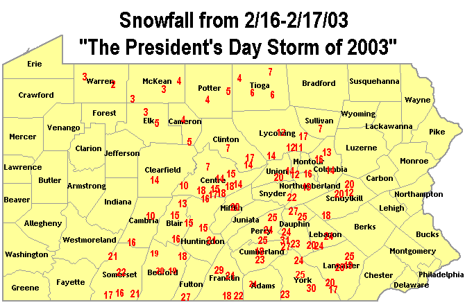
The numbers plotted above represent co-op and spotter snowfall totals through Monday Evening, 2/17/03. Additional light snow fell overnight into the morning of the 18th. The President's Day Storm of 2003 began on the Sunday the 16th, and made snow for Central Pennsylvania through the morning of the 18th. The heaviest snow fell over the region late Sunday night into Monday morning, the 17th of February (President's Day). Many residents woke on Monday morning to see 12 to 30 inches of new snow on their driveways, sidewalks and rooftops. Many places in the Lower Susquehanna Valley (Harrisburg, Lancaster, Lebanon, York, Gettysburg) got close to (or in excess of) their normal SEASONAL snowfall during this single storm. The storm impacted all of the Eastern seaboard, and clogged travel throughout the Urban Corridor of Washington, DC, Philadelphia, New York and Boston. |
 Caption |
 |
Media use of NWS Web News Stories is encouraged! Please acknowledge the NWS as the source of any news information accessed from this site. |
 |
US Dept of Commerce
National Oceanic and Atmospheric Administration
National Weather Service
State College, PA
328 Innovation Blvd, Suite 330
State College, PA 16803
(814)954-6440
Comments? Questions? Please Contact Us.


 Send Us a Report