...NWS Damage Survey for 07/29/21 Tornado in Laurel Hill State Park...

The National Weather Service in collaboration with Somerset County
Emergency Management confirms an EF-1 tornado occurred within Laurel
Hill State Park from approximately 2:25 PM EDT through 2:28 PM EDT on
Thursday, July 29, 2021.

.Laurel Hill State Park Tornado...

Rating: EF-1
Estimated Peak Wind: 102 mph
Path Length /statute/: 0.2 miles
Path Width /maximum/: 65 yards
Fatalities: 0
Injuries: 0

Start Date: July 29, 2021
Start Time: 2:25 PM EDT
Start Location: North of Laurel Hill Park Drive, Laurel Hill SP
Start Lat/Lon: 40.0099/-79.2367

End Date: July 29, 2021
End Time: 2:28 PM EDT
End Location: East of Laurel Hill Park Drive, Laurel Hill SP
End Lat/Lon: 40.0079/-79.2338

A tornado developed within Laurel Hill State Park during the afternoon hours
of Thursday, July 29, 2021. Somerset County Emergency Management conducted a
thorough damage survey, consisting of photos from the ground along with photos
and videos from a drone. The tornado began just north of Laurel Hill Park
Drive and continued on a southeast track through a portion of the park containing
several conservation buildings. Numerous trees were uprooted in various directions,
while a few were also snapped, resulting in damage to some of the conservation buildings.
Estimated maximum winds reached 102 mph as the tornado tracked through this portion of the
park, before turning to the east and producing additional tree damage east of Laurel Hill
Park Drive. Additionally, several videos of the tornado were sent in to the NWS from media
partners and storm spotters. Farther west on Laurel Hill Park road, near the intersection
with Buck Run Road, scattered unidirectional wind damage was found in association with the
rear flank downdraft of the tornado.


&&

EF Scale: The Enhanced Fujita Scale classifies tornadoes into the
following categories:

EF0...Weak......65 to 85 mph
EF1...Weak......86 to 110 mph
EF2...Strong....111 to 135 mph
EF3...Strong....136 to 165 mph
EF4...Violent...166 to 200 mph
EF5...Violent...>200 mph

NOTE:
The information in this statement is preliminary and subject to
change pending final review of the events and publication in NWS
Storm Data.
...NWS Damage Survey for 07/29/21 Tornado near Myerstown...

The National Weather Service in collaboration with the Lebanon County
Department of Emergency Services confirms an EF-0 tornado occurred just
northwest of Myerstown, PA from approximately 5:34 PM EDT through 5:38
PM EDT on Thursday, July 29, 2021.

.Myerstown Tornado...

Rating:                 EF-0
Estimated Peak Wind:    80 mph
Path Length /statute/:  0.75 miles
Path Width /maximum/:   60 yards
Fatalities:             0
Injuries:               0

Start Date:             July 29, 2021
Start Time:             5:34 PM EDT
Start Location:         About 4.3 miles NW of Myerstown near Houtztown Rd.
Start Lat/Lon:          40.4295/-76.3523

End Date:               July 29, 2021
End Time:               5:38 PM EDT
End Location:           About 3.7 miles NW of Myerstown near Kutztown Rd.
End Lat/Lon:            40.4263/-76.3389

A tornado developed just northwest of Myerstown, beginning near Houtztown
Road and traveling southeast before ending near Kutztown Road. A children`s
playset was knocked over along with a few trees being uprooted following
a metal gate being destroyed. A portable toilet was thrown about 40 feet
right before a row of corn was flattened, clearly showing a convergent
wind pattern. Farther southeast, a vehicle was displaced a few feet within
a junk yard, prior to the tornado shredding some leaves before lifting just
before reaching Kutztown Road.

&&

EF Scale: The Enhanced Fujita Scale classifies tornadoes into the
following categories:

EF0...Weak......65 to 85 mph
EF1...Weak......86 to 110 mph
EF2...Strong....111 to 135 mph
EF3...Strong....136 to 165 mph
EF4...Violent...166 to 200 mph
EF5...Violent...>200 mph

NOTE:
The information in this statement is preliminary and subject to
change pending final review of the event and publication in NWS
Storm Data.
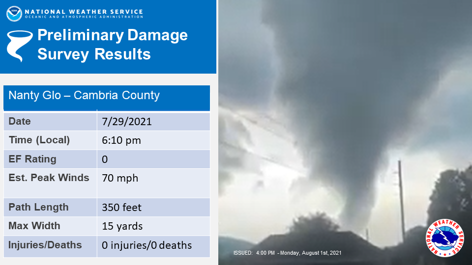
...NWS Damage Survey for 07/29/2021 Tornado near Nanty Glo... The National Weather Service in collaboration with the Cambria County Department of Emergency Services confirms an EF-0 tornado occurred just north of Nanty Glo from approximately 6:10 PM EDT through 6:11 PM EDT on Thursday, July 29, 2021. .Nanty Glo Tornado... Rating: EF-0 Estimated Peak Wind: 70 mph Path Length /statute/: 350 feet Path Width /maximum/: 15 yards Fatalities: 0 Injuries: 0 Start Date: July 29, 2021 Start Time: 6:10pm Start Location: West side of Blacklick Valley High School football field Start Lat/Lon: 40.480300/-78.838300 End Date: July 29, 2021 End Time: 6:11pm End Location: East side of Blacklick Valley High School football field End Lat/Lon: 40.480200/-78.837100 A tornado developed on the western side of the Blacklick Valley High School football field and moved southeast across the field before lifting on the eastern side of the football field. The tornado displaced small bleachers and knocked over a portable toilet. A few trees around the football field were snapped. && EF Scale: The Enhanced Fujita Scale classifies tornadoes into the following categories: EF0...Weak......65 to 85 mph EF1...Weak......86 to 110 mph EF2...Strong....111 to 135 mph EF3...Strong....136 to 165 mph EF4...Violent...166 to 200 mph EF5...Violent...>200 mph NOTE: The information in this statement is preliminary and subject to change pending final review of the event and publication in NWS Storm Data. |
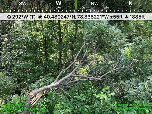
Tree Damage
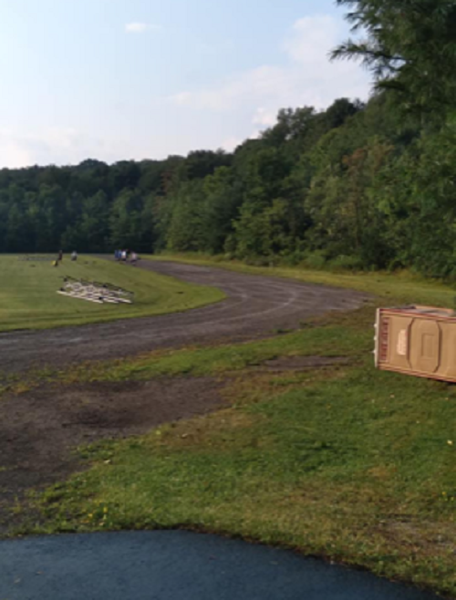
Bleachers and portable toilet displaced


 Send Us a Report