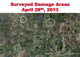
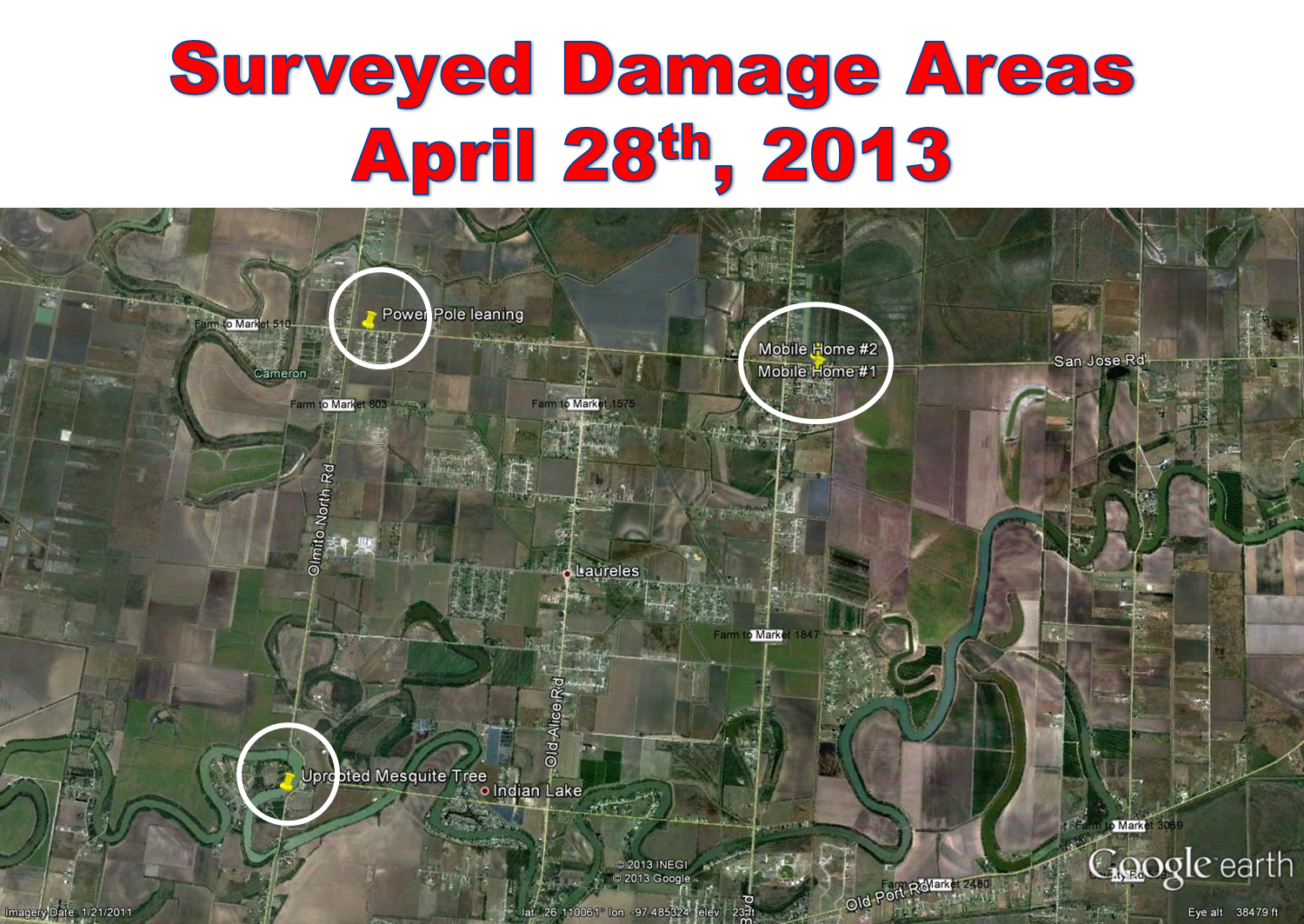
Map of notable surveyed damage in and near Laureles, Texas, from microburst winds on April 28th, 2013.
Event
A small but potent line of strong to severe thunderstorms dumped torrential rains, produced frequent lightning strikes, and slammed heavy winds across much of the Rio Grande Valley during the afternoon of April 28th. Hazards and impacts included:
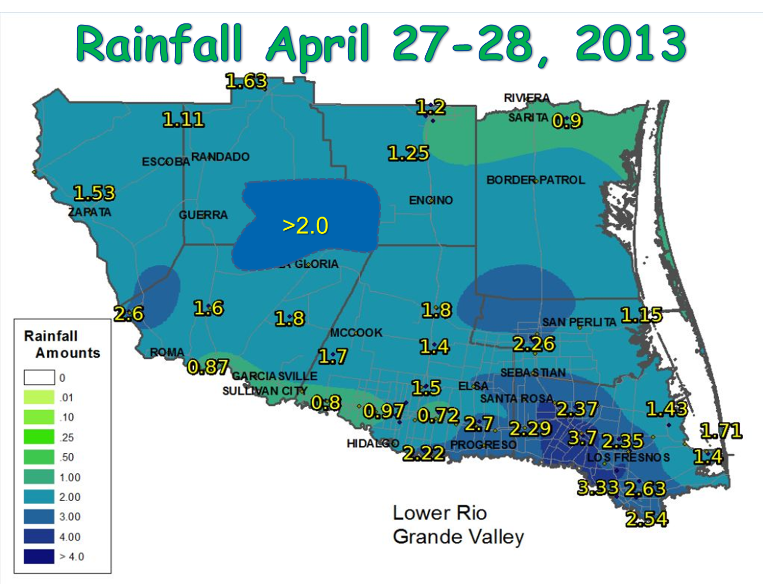
- Rain. Two to nearly four inches pounded most cities and towns east of Highway 281. Rainfall rates as hjigh as 1.5" in 20 minutes during the primary storm, which occurred in half hour intervals between noon (McAllen/Edinburg) and 2 PM (Port Isabel/South Padre) reduced visibility to near zero, left up to two feet of floodwaters in the usual poor drainage locations, and soaked thirsty fields and pastures.
- At Harlingen/Valley International Airport, the 2.37 inches destroyed the previous April 28th record of 1.13 inches set in the late 1950s. The single day total was the highest since September 19th, 2010, when 3.04 inches fell!
- At Brownsville/South Padre Island International Airport, 2.65 inches set a new daily record, besting the 2.43 inches that fell in 1989. This was the highest single day total since August 6th, 2012, when 3.08 inches fell.
- At McAllen/Miller International Airport, 1.12 inches fell, the largest single day total since October 18th, 2012, when 1.37 inches fell
- Lightning. Frequent cloud to ground strikes contributed to thousands of power outages across Hidalgo and Cameron County. AEP Texas, which serves much of Cameron and Hidalgo County, reported more than 10 thousand customers without power near the peak of the storm in Hidalgo, and nearly 7 thousand in Cameron. Brownsville Public Utilies Board (PUB) reported 1,200 persons without power, including the University of Texas at Brownsville Campus.
- Wind. A swath of very strong winds accompanied the squall line through eastern Hidalgo, Cameron, and southern Willacy County. Peak gusts included:
- 53 mph at Bayview/Cameron County Airport.
- 51 mph at Harlingen/Valley International Airport.
- 48 mph at McAllen/Miller International Airport
- 44 mph at Edinburg International Airport
- 40 mph at Brownsville/South Padre Island International Airport and at South Padre Island Heliport.
- 31 mph at Weslaco/Mid Valley Airport.
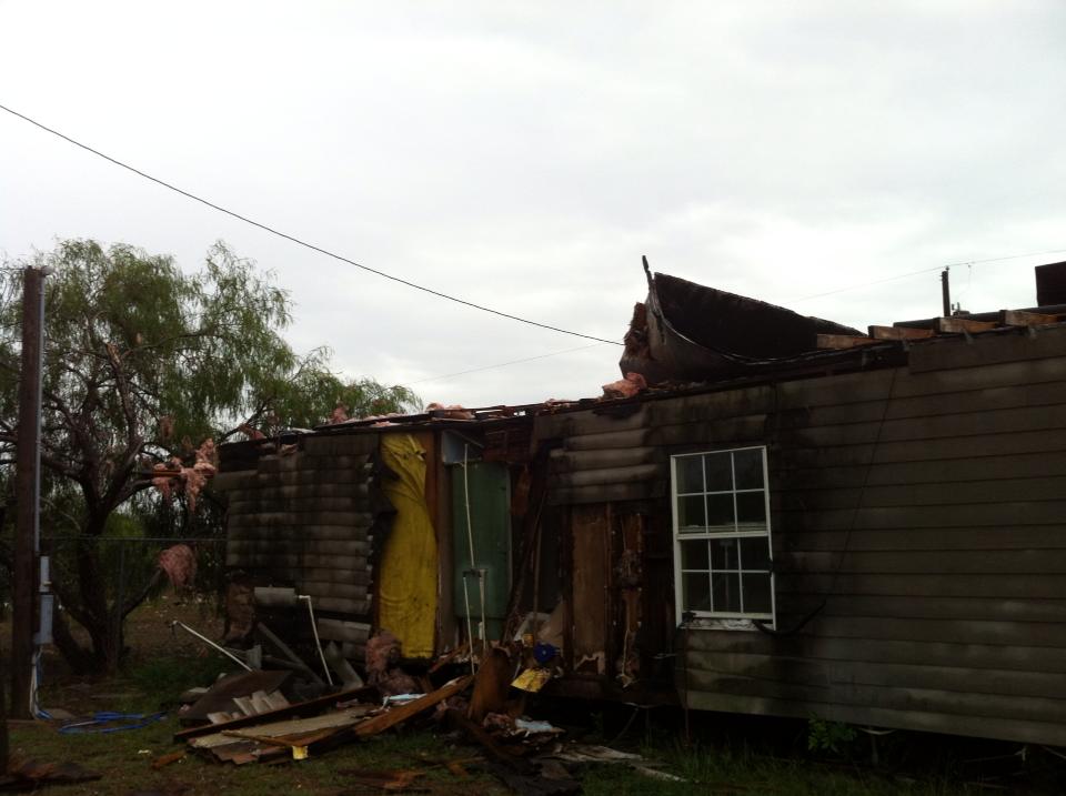
- Wind Damage. The microburst powered up when it reached Cameron County, and ultimately caused significant damage to two poorly built mobile trailers in North Los Fresnos (locations shown above). Surrounding damage in Olmito, Rancho Viejo, and other neighborhoods included dozens of snapped mesquite limbs, several uprooted trees, and at least one leaning power pole. The tale of the tape:
- Peak Wind Speed (estimated by survey): 60 to 65 mph.
- Time of Peak Speed: 125 PM, both in Los Fresnos and North Brownsville
- Damage Details: In North Los Fresnos, two tin roofs were lifted from old, poorly constructed trailers. Severe water and structural damage occurred at each residence; insulation was peeled from the roofs and some walls had cracked or collapsed. Both structures were uninhabitable. Nine persons were displaced. In North Brownsville, a trampoline was lofted into and over a fence before landing on the other side of a thoroughfare.
|
Meteorology
An upper level disturbance helped induce a weak low pressure system in the lee of the northern Sierra Madre mountains. Strengthening southeast winds combined with the disturbance and old boundaries from thunderstorms overnight on the 27th to produce the first widespread, locally heavy rainfall event for the Rio Grande Valley since January 8th and 9th, a span of more than three months! Rainfall generally ranged from 1 to 3 inches. Higher values, 3 to nearly 4 inches, fell in a swath from near Mercedes (southeast Hidalgo County) through San Benito and Harlingen (Table and map, below). A second swath of an estimated two inches or more covered portions of the Jim Hogg County ranchlands, in two batches; one overnight on the 27th, and a second early on the 28th.
Soon after daybreak on the 28th, the ranchland storms organized into a brief but potent squall line that moved from Zapata through Starr County. The line disintegrated into disorganized and weaker clusters by late morning while moving through eastern Starr and western Hidalgo County, then reloaded into a formidable line of torrential rainfall, frequent cloud to ground lightning, and enhanced downburst winds around noon. The line crossed the vast majority of the populated Rio Grande Valley between noon and 230 PM, and produced urban flooding in all poor drainage locations from Edinburg to Brownsville. As the storms crossed into Cameron County, individual bow–shaped structures (bottom of page) surged toward the coast. Radar indicated cores suggested 60 mph or greater winds just above the surface, some of which translated into an area of minor damage to trees and limbs, and at least two ripped off roofs north of Los Fresnos.
Drought...Out?
One could only dream.
It will take many more events like these to remove the Extreme to Exceptional drought conditions that have built up over more than 2 and ½ years! And, those events would need to be spaced much closer together than ones that have already occurred during the current record drought. Just to refresh the memory, a partial list of wet periods embedded within the drought which began in October 2010:
Would this be just another in the series of infrequent, but helpful, rain events in a desert of dry weather? As of this writing, long range models through mid May suggested a return to largely rain free weather with temperatures gradually warning toward the expected swelter that arrives thereafter. The longer term forecast of eventual searing heat, and a "lean" toward lower rainfall totals, remained intact.
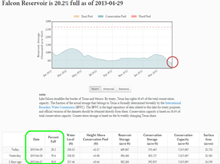
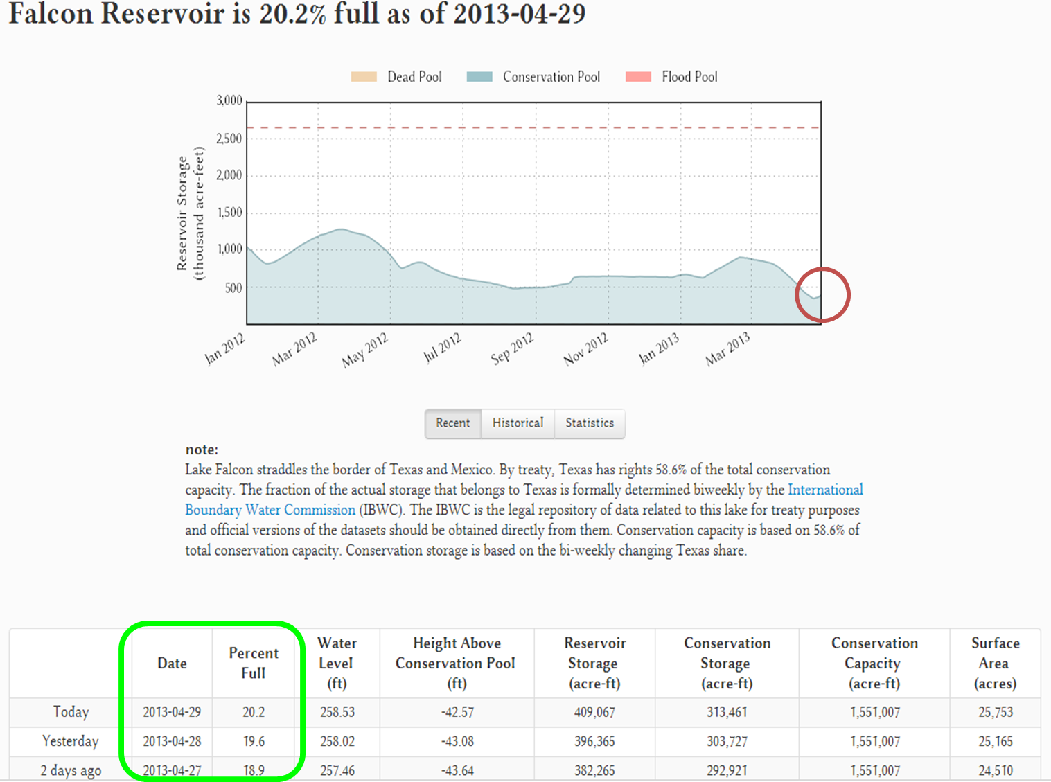
Falcon International Reservoir conservation level as of 2 PM CDT, April 29th. Slight increase (circled area, right) was due to a combination of releases of water from Amistad International Reservoir, which reached record lows on April 26th, 2013, and heavy rainfall along and west of the Rio Grande near Laredo on April 27th. |
")
")

