 Loop of 1.4° radar base reflectivity between 404 PM and 545 PM across the Lower Rio Grande Valley on May 12th. Note the rapid development of cells in Cameron County, with others forming rapidly near Weslaco (southeast Hidalgo). South moving boundaries from earlier storms near Raymondville triggered the newer development. |
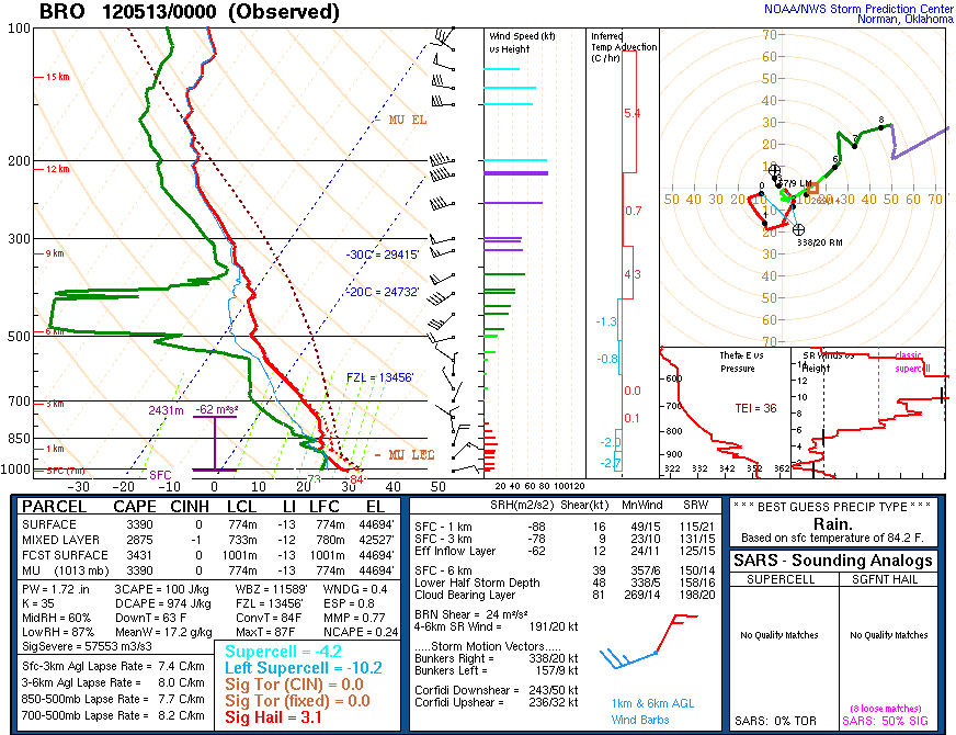 Atmospheric profile from Brownsville, posted at 7 PM with initial data sampled closer to 6 PM, soon after hailstorms raced through the Lower Valley. Click for larger version. The combination of dry air aloft, a very steep temperature drop with height, and a trigger in the form of a boundary between much drier and much more humid air near the surface aided rapid updraft formation. |
| Oh, Yes it Did... ...Hail (Again) in portions of the Rio Grande Valley on May 12th 2012 |
|
|
Recap A preliminary storm report follows. Note that some times are estimated after reconciliation with radar, and may not match earlier preliminary reports that can be found online.
PRELIMINARY LOCAL STORM REPORT...SUMMARY
NATIONAL WEATHER SERVICE BROWNSVILLE TX
731 PM CDT SAT MAY 12 2012

..TIME...   ...EVENT...      ...CITY LOCATION...     ...LAT.LON...
..DATE...   ....MAG....      ..COUNTY LOCATION..ST.. ...SOURCE....
            ..REMARKS..

0705 PM     HAIL             FALFURRIAS              27.22N  98.14W
05/11/2012  E1.00 INCH       BROOKS             TX   LAW ENFORCEMENT

0406 PM     HAIL             E RAYMONDVILLE          26.48N  97.78W
05/12/2012  E0.88 INCH       WILLACY            TX   PUBLIC

            NICKLE SIZE HAIL NEAR RAYMONDVILLE ABOUT 2 MILES EAST
            OF HWY 77

0425 PM     HAIL             1 N RAYMONDVILLE        26.49N  97.78W
05/12/2012  E1.00 INCH       WILLACY            TX   PUBLIC

            PUBLIC REPORTED QUARTER SIZE HAIL ON NORTH SIDE OF
            RAYMONDVILLE

0425 PM     HAIL             7 N RAYMONDVILLE        26.58N  97.78W
05/12/2012  E1.00 INCH       WILLACY            TX   EMERGENCY MNGR

            EMERGENCY MANAGER REPORTED QUARTER SIZE HAIL NEAR
            YTURRIA

0434 PM     HAIL             RAYMONDVILLE            26.48N  97.78W
05/12/2012  M0.88 INCH       WILLACY            TX   BROADCAST MEDIA

            PUBLIC VIA BROADCAST METEOROLOGIST REPORTED NICKEL SIZE
            HAIL AT THE CORNER OF 1ST AND TAMPICO

0500 PM     HAIL             RAYMONDVILLE            26.48N  97.78W
05/12/2012  E1.00 INCH       WILLACY            TX   PUBLIC

            PUBLIC REPORTED QUARTER SIZE HAIL ON BUS NEAR
            RAYMONDVILLE

0510 PM     HAIL             2 W HARLINGEN           26.20N  97.72W
05/12/2012  M0.75 INCH       CAMERON            TX   PUBLIC

            PALM VALLEY RESIDENT REPORTED 5 PALM TREES SET ON FIRE
            BY LIGHTNING.

0515 PM     HAIL             2 W HARLINGEN           26.20N  97.72W
05/12/2012  M0.88 INCH       CAMERON            TX   PUBLIC

            WEST SIDE OF HARLINGEN ALONG HIGHWAY 77 83 REPORTED
            NICKEL SIZE HAIL

0520 PM     HAIL             HARLINGEN               26.20N  97.69W
05/12/2012  M0.75 INCH       CAMERON            TX   PUBLIC

            PENNY SIZE HAIL AT HARRISON AND HWY 77

0520 PM     HAIL             HARLINGEN               26.20N  97.69W
05/12/2012  M0.75 INCH       CAMERON            TX   AMATEUR RADIO

            PENNY HAIL RELAYED BY HAM OPERATER FROM GENERAL PUBLIC

0525 PM     HAIL             3 W HARLINGEN           26.20N  97.73W
05/12/2012  M1.00 INCH       CAMERON            TX   PUBLIC

            NICKEL TO QUARTERS AT ALTAS PALMAS AND HWY 83

0532 PM     HAIL             2 W HARLINGEN           26.20N  97.72W
05/12/2012  M1.00 INCH       CAMERON            TX   PUBLIC

            RELAYED REPORTED FROM SPOUSE OF NWS EMPLOYEE. QUARTER
            SIZE HAIL BROKE CAR WINDSHEILD ALONG HWY 83 WEST SIDE OF
            HARLINGEN

0532 PM     HAIL             HARLINGEN               26.20N  97.69W
05/12/2012  M1.00 INCH       CAMERON            TX   EMERGENCY MNGR

            CAMERON COUNTY EM HUMBERTO BARRERA REPORTED QUARTER
            SIZE HAIL AT COUNTY ROAD 800 AND RANGERVILLE RD.

0545 PM     HAIL             LA FERIA                26.16N  97.82W
05/12/2012  E1.00 INCH       CAMERON            TX   PUBLIC

            PUBLIC REPORTED QUARTER SIZE HAIL NEAR LA FERIA.

0600 PM     HAIL             6 SE LA FERIA           26.09N  97.77W
05/12/2012  M1.00 INCH       CAMERON            TX   TRAINED SPOTTER

            SKYWARN SPOTTER NEAR REPORTED QUARTER SIZE HAIL NEAR
            RANGERVILLE
|
|

