National Weather Service United States Department of Commerce


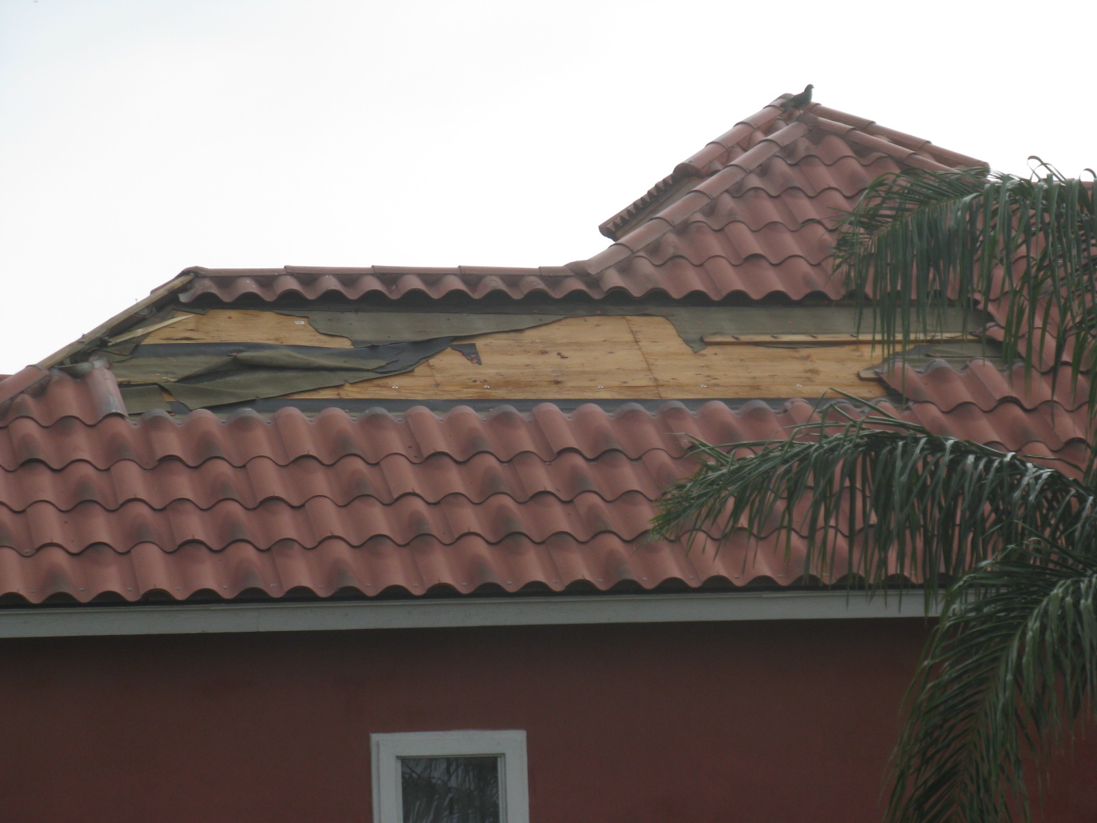
Photos taken from San Benito, Texas after tornado containing 80 mph winds damaged property and portions of a large single family home early on May 11th, 2012. For individual photos, click here.
Uncle!
Squall Line Brings Soaking Rains, More Hail, and Tornadoes
 
Midnight to Daybreak Storms May 11th End Week of Active Spring Weather

Episode
Vigorous energy cycling around a seasonally strong upper level disturbance crashing into Texas brought a final round of potent thunderstorms through much of the Rio Grande Valley during the late night hours of May 10th into daybreak on May 11th. Initial severe thunderstorms and isolated tornadoes pummeled the Coastal Bend and South Texas Plains from Corpus Christi to near Laredo during the evening of the 10th. As night progressed, pockets of colder air behind the initial line pushed its west end southward; just before midnight, this end would link up with individual cells moving off the Sierra Madre west of Zapata County and form a separate, smaller line from Jim Hogg to Zapata County. This line quickly intensified and dumped heavy rain, high winds some large hail, and one confirmed tornado. As the line marched from the Ranchlands into the Rio Grande Valley, it weakened a bit; as the remnants neared the coast before daybreak, individual small rotating storms developed and redeveloped in Cameron County, with several reports of funnel clouds and at least one confirmed tornado in San Benito.

San Benito Tornado
The strongest of the mini rotating storms (below) spun up one of the briefest tornadoes one might find: A touchdown that lasted no longer than a minute, with a track only one tenth of a mile and 50 yards wide. Unfortunately, the single family home underneath the touchdown sustained significant damage,shown in the photo gallery at the top of this page and listed in the report below. Tornado indicators were evident in the cyclone fence, which was bent in different directions in four separate areas, three large mesquite limbs which were tossed from a tree that could not be determined, trees snapped or leaning in different directions around the house, and uplift of unanchored items on the ground such as a carport and boat/trailer (above). Quick facts are as follows:

  • Event: EF0 Tornado (80 mph wind)
  • Time: 315 to 316 AM CDT, May 11th
  • Path Length: 0.10 mile
  • Path Width: 50 yards

Other Events, in Brief

  • Flooding and Rainfall. Heavy rains in Zapata County flooded Highway 83, the thoroughfare between the Rio Grande Valley and Laredo, with 3 feet of water, closing the road for two hours south of Zapata. Other minor flooding was reported in Zapata. Rainfall was more welcome in the Lower and Mid Valley, with many locations between San Benito, Harlingen, and McAllen receiving 1 to 2 inches of soaking.
  • Wind. Estimated gusts 65 to 70 mph were reported in Zapata; damage unknown as of this writing.
  • Tornadoes and Funnels. In addition to the San Benito tornado discussed above, another tornado was confirmed in Randado along State Highway 16 (Jim Hogg County). A potential tornado had yet to be confirmed near Rio Hondo; several reports of funnels were received during the early morning of the 11th in Cameron County. In all cases, touchdowns/visuals were very brief (a minute or less)
  • Lightning and Power Loss. The south half of the City of Zapata was without power during the peak of the storm, and more than 4,200 customers in central McAllen lost power most likely beginning at 4 AM. Lightning caused a structure fire and knocked out some power in Pharr, and brief power outages were noted in San Benito and Laguna Vista/Bayview.

The following are preliminary storm reports from events of May 10th/11th.

PRELIMINARY LOCAL STORM REPORT...SUMMARY
NATIONAL WEATHER SERVICE BROWNSVILLE TX
415 PM CDT FRI MAY 11 2012

..TIME...   ...EVENT...      ...CITY LOCATION...     ...LAT.LON...
..DATE...   ....MAG....      ..COUNTY LOCATION..ST.. ...SOURCE....
            ..REMARKS..

1120 PM     HAIL             ZAPATA                  26.89N  99.26W
05/10/2012  E1.00 INCH       ZAPATA             TX   COUNTY OFFICIAL 

            QUARTER SIZE HAIL. SPECIFIC LOCATION WITHIN CITY 
            UNKNOWN. 

1122 PM     TSTM WND GST     ZAPATA                  26.89N  99.26W
05/10/2012  E70 MPH          ZAPATA             TX   TRAINED SPOTTER 

            TRAINED SPOTTER ESTIMATED WIND GUSTS OF 65 TO 70 MPH IN 
            DOWNTOWN ZAPATA AT THE INTERSECTION OF 5TH AVE AND 
            LINCOLN ST. 

1124 PM     HAIL             ZAPATA                  26.89N  99.26W
05/10/2012  E0.75 INCH       ZAPATA             TX   TRAINED SPOTTER 

            TRAINED SPOTTER REPORTED PENNY SIZED HAIL IN DOWNTOWN 
            ZAPATA AT THE INTERSECTION OF 5TH AVE AND LINCOLN ST. 

1128 PM     HAIL             RANDADO                 27.08N  98.87W
05/10/2012  E1.00 INCH       JIM HOGG           TX   LAW ENFORCEMENT 

            SHERIFFS OFFICE REPORTED QUARTER SIZED HAIL. 

1140 PM     FLASH FLOOD      7 SE ZAPATA             26.82N  99.18W
05/10/2012                   ZAPATA             TX   LAW ENFORCEMENT 

            ZAPATA COUNTY SHERIFFS OFFICE REPORTS 3 FEET OF FLOWING 
            WATER ON HIGHWAY 83 IN THE VICINITY OF EL CLARENO RANCH 
            7 MILES SOUTH OF ZAPATA. HIGHWAY 83 CLOSED FROM ABOUT 
            1140 PM UNTIL 130 AM. OTHER MINOR FLOODING NEAR MEDINA 
            ADDITION ALONG SR 16. 

1200 AM     TORNADO          RANDADO                 27.08N  98.87W
05/11/2012                   JIM HOGG           TX   LAW ENFORCEMENT 

            JIM HOGG COUNTY SHERIFF DEPARTMENT REPORTS TORNADO 
            BRIEFLY TOUCHED DOWN AT THE INTERSECTION OF HIGHWAY 16 
            AND FM 649 IN THE VICINITY OF RANDADO. 

0316 AM     TORNADO          1 E SAN BENITO          26.14N  97.62W
05/11/2012                   CAMERON            TX   NWS STORM SURVEY

            BRIEF TOUCHDOWN AT SINGLE FAMILY HOME IN SOUTHEAST SAN 
            BENITO. ROOF TILES BLOWN OFF...CYCLONE FENCES 
            DOWN...BOAT AND TRAILER FLIPPED OVER...CARPORT HEAVILY 
            DAMAGED...SEVERAL SNAPPED LIMBS. PRELIMINARY RATING... 
            EF0...80 MPH. PATH LENGTH... 0.10 MILES. PATH WIDTH... 
            50 YARDS. 

0340 AM     TORNADO          4 N RIO HONDO           26.29N  97.58W
05/11/2012                   CAMERON            TX   PUBLIC          

            PUBLIC REPORTED MULTIPLE TOUCHDOWNS OF A 
            LIGHTNING-ILLUMINATED SMALL TORNADO IN A FIELD ON FM 508 
            NEAR RIO HONDO. CROP DEBRIS WAS SEEN. 

0633 AM     FUNNEL CLOUD     5 WSW LOS FRESNOS       26.05N  97.55W
05/11/2012                   CAMERON            TX   OTHER FEDERAL   

            INTERNATIONAL BOUNDARY AND WATER COMMISSION EMPLOYEE 
            REPORTED FUNNEL CLOUD DROPPED HALFWAY TO THE GROUND 
            TWICE IN THE IMMEDIATE VICINITY OF LAURELES. GENERAL 
            PUBLIC REPORTED THE SAME FUNNEL ABOUT 5 MILES NORTHEAST 
            OF SAN PEDRO. NO DAMAGE REPORTED... UNCLEAR WHETHER 
            FUNNEL TOUCHED DOWN IN OPEN LAND OR NOT. LASTED 10 TO 20 
            SECONDS IN FIRST INSTANCE. SECOND INSTANCE TWO MINUTES 
            LATER. LOCATION ESTIMATED. 

0709 AM     FUNNEL CLOUD     2 E LAGUNA VISTA        26.10N  97.26W
05/11/2012                   GMZ130             TX   LAW ENFORCEMENT 

            LAGUNA VISTA POLICE DEPARTMENT REPORTS FUNNEL CLOUD 
            OVER LAGUNA MADRE TRYING TO FORM WATERSPOUT. 

0715 AM     FUNNEL CLOUD     SOUTH PADRE ISLAND      26.08N  97.18W
05/11/2012                   CAMERON            TX   PUBLIC          

            PUBLIC REPORTS FUNNEL CLOUD ON SOUTH PADRE ISLAND. 

            
Two panel radar images showing reflectivity and velocity swirling above south side of San Benito
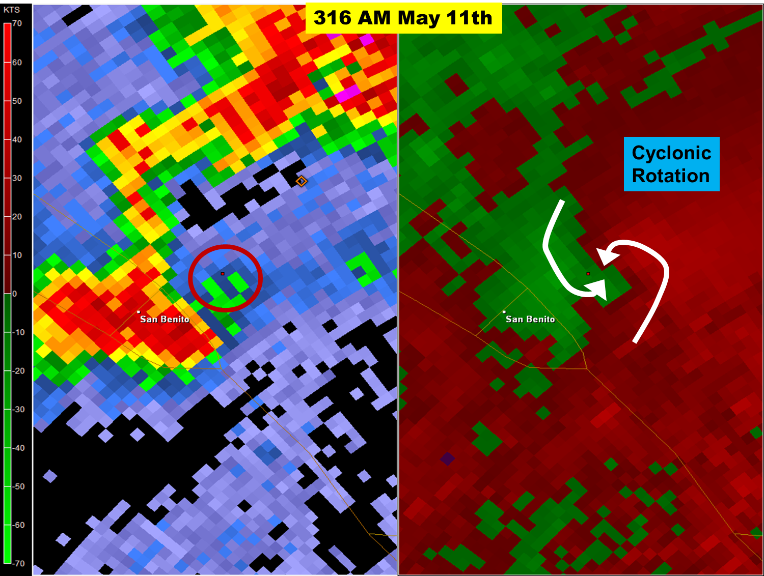
Radar image of base reflectivity (left) and velocity (right) at around 2500 feet above ground level. Cyclonic rotation, indicated by the white arrows "curling" into each other, peaked very close to the location of the twister.