Colorado Winter Weather Preparedness Week - October 16-22, 2022
The National Weather Service wants everyone to be part of a Weather-Ready Nation. With the return of winter, Colorado receives a variety of hazards in the form of snow, wind chill, high winds, and avalanches. Are you winter weather ready? Now is the time to make sure you know how to stay safe when winter weather arrives. This week, October 16-22, is Colorado Winter Weather Preparedness Week.
Snow in Colorado is important to the farmers, the ski areas, and for filling up reservoirs. However, winter storms often bring heavy snow, bitterly cold air, high winds, low visibility, and slick roads. This can lead to dangerous travel conditions and other life-threatening situations such as avalanches and very frigid wind chill temperatures.
The National Weather Service offices which cover Colorado will issue a series of public information statements during the week covering the following topics:
Sunday - Introduction
Monday - Winter Travel
Tuesday - Watches Warnings & Advisories
Wednesday - High Wind
Thursday - Wind Chill & Hypothermia
Friday - Avalanche Safety
Saturday - Review
WINTER WEATHER PREPAREDNESS WEEK IN COLORADO
The week of October 17 through October 23 is Winter Weather Preparedness Week in Colorado. This is an excellent time for all individuals, families, businesses, schools, and media outlets to review their winter storm preparedness plans. It is especially important for all new arrivals to the state to become familiar with the National Weather Service watch and warning definitions, as well as winter safety procedures.
Snow in Colorado is important to the farmers, the ski areas, and for filling up reservoirs. However, winter storms often bring heavy snow, bitter cold air, high winds, low visibilities and slick roads. This can lead to dangerous travel conditions and other life threatening situations such as avalanches and very frigid wind chill temperatures. To help you prepare for these hazards this coming winter, the National Weather Service offices in Colorado will issue statements throughout the week to discuss:
Monday…………Winter Travel Safety
Tuesday…………Watches, Warnings, and Advisories
Wednesday……...High Winds
Thursday……..…Wind Chill Temperatures and Hypothermia
Friday…………..Avalanche Safety
Saturday………..Winter Weather Preparedness Week in Review
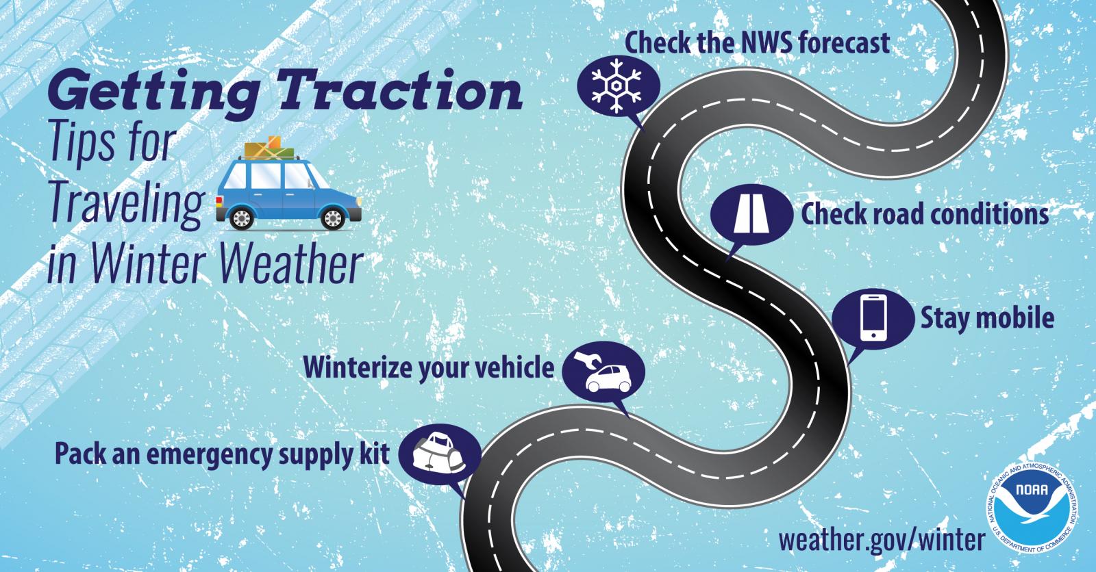
WINTER TRAVEL SAFETY
Before winter weather arrives in earnest, it is highly recommended that you prepare your car or truck for winter travel.
A well-equipped vehicle has adequate tires, tire chains, tow rope, sand or cat litter for traction, shovel, tool kit, windshield scraper and brush, battery cables, first aid kit, flashlight, extra batteries, blankets and/or sleeping bags, extra clothing, candles, waterproof matches, jug of water, high calorie packaged food for quick energy, and an empty can to melt snow for drinking.
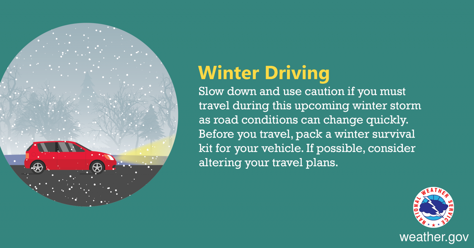
And during winter weather events, the best way to prevent treacherous winter travel is to avoid it. This can be done by staying informed about current weather and road conditions as well as the latest weather forecasts. Information on road conditions in Colorado is available on the web at www.cotrip.org or from the toll free number 1-877-315-7623. When calling from anywhere in Colorado, dialing 511 will also access the Colorado road reports. Additionally, a free smartphone application, CDOT Mobile, is available.
If you should become stranded during a winter storm, stay with your vehicle and do not panic. If accompanied by others, take turns sleeping. Run the motor every hour for about ten minutes to maintain warmth, but keep windows open a little to prevent the buildup of carbon monoxide. Make sure the exhaust pipe is not blocked. Keep the car visible with brightly colored cloths tied to the side view mirrors, door handles, or external antenna. At night, turn on the dome light when running the engine. Exercise periodically by vigorously moving arms, legs, toes and fingers.
In the mountains, avalanches become a possibility in the winter, especially below steep slopes. Avalanches occasionally come down across roads, with little or no warning. However, avalanche control work is performed on many avalanche prone roads in Colorado, making the roads safer to travel. Caution is advised when traveling along avalanche prone roads, especially during and shortly after a heavy snowstorm, as well as during periods of rapid snowmelt.
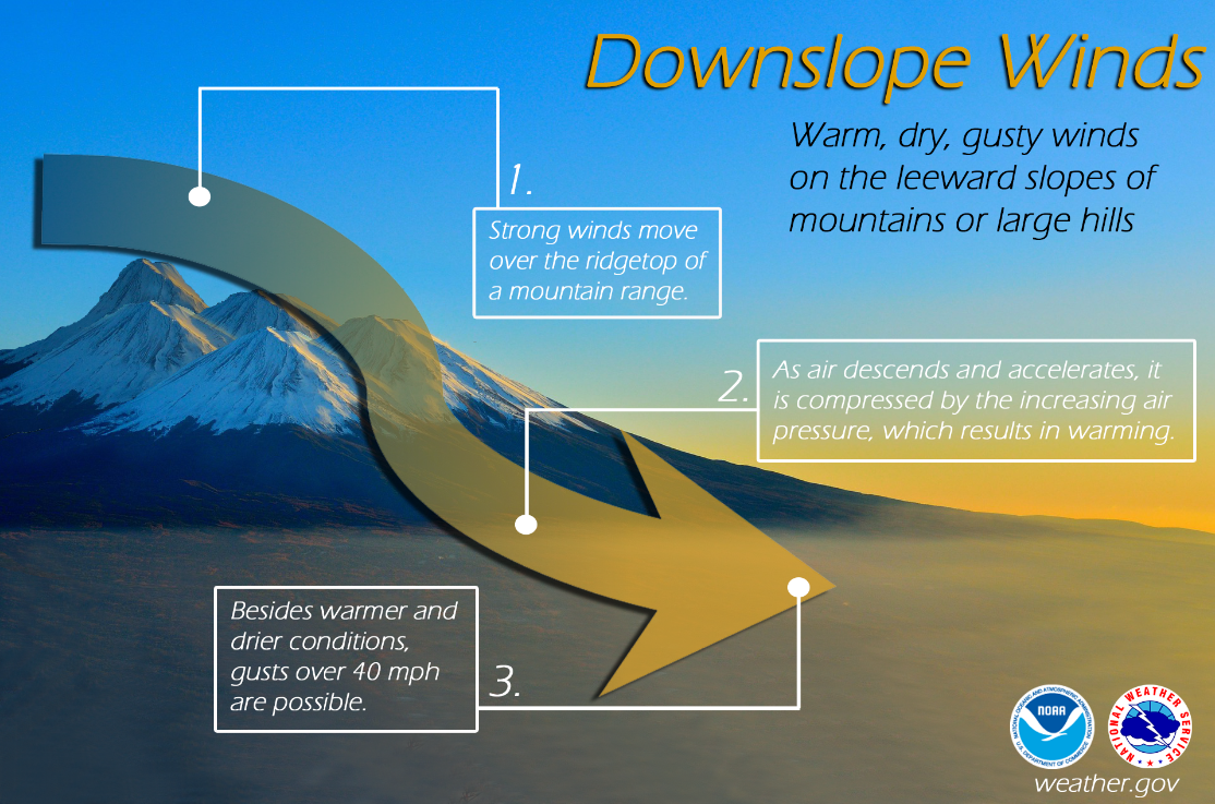
Very strong downslope winds occur at times mainly along the front range of Colorado. These Chinook and Bora winds can have gusts exceeding 100 mph. Persons planning travel in lightweight or high-profile vehicles should avoid travel during these strong wind events especially on northsouth oriented roads.
Roads which appear to be clear in the wintertime may actually be coated with a thin layer of ice, commonly known as black ice. This nearly invisible ice layer can cause you to rapidly lose control of your vehicle. Black ice is most common during the nighttime hours. If you detect black ice you should reduce your speed.
Please follow these winter travel safety recommendations which could save your life.
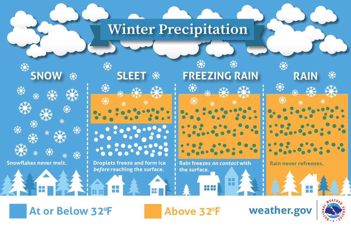
WHAT DOES THAT WARNING MEAN?
When a warning is issued during the winter season, will you know what it means, and will you know how to respond? During this Colorado Winter Weather Preparedness Week, please become familiar with our list of potentially life-saving winter weather products.
OUTLOOKS
A Hazardous Weather Outlook is issued daily by the National Weather Service office in Boulder Colorado. The outlook provides information on potentially hazardous weather out to 7 days into the future. Also, the Weather Story, a graphic of expected hazardous weather, is posted daily on National Weather Service web sites.
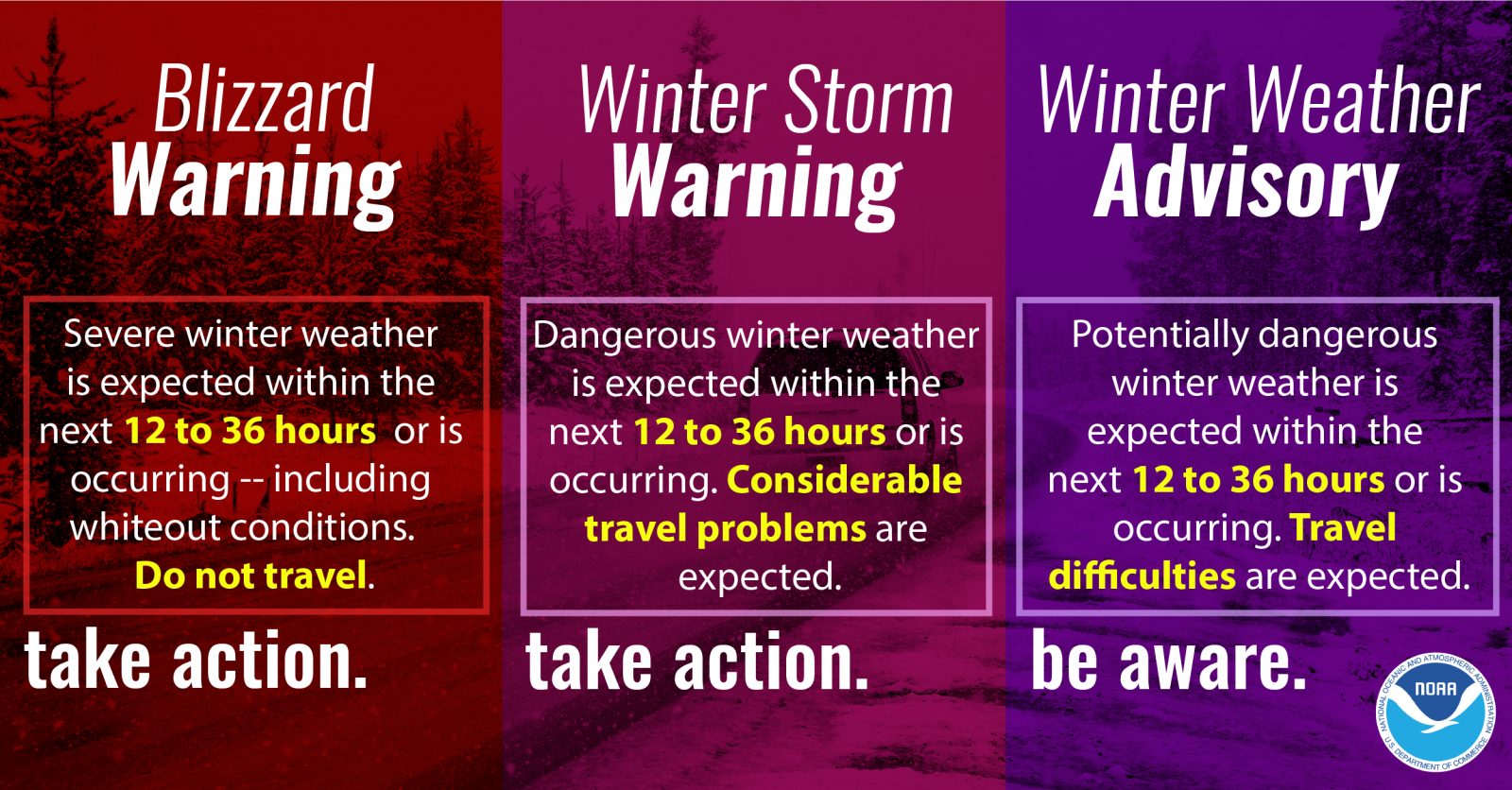
WATCHES AND WARNINGS
A Winter Storm Watch is issued when hazardous winter storm conditions are possible within the next 3 to 4 days, but the timing, intensity, or occurrence may still be uncertain. In contrast, a Winter Storm Warning is issued for potentially life-threatening winter storm conditions, such as heavy snowfall or a combination of snowfall and blowing snow, which are likely to occur within the next 1 to 2 days. Impacts such as timing of winter weather on rush hour are also considered when issuing Watches and Warnings.
Winter Storm
Winter Weather Advisory
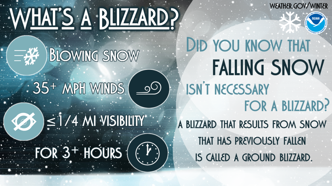
Blizzard
Plains: 6" in 12 hours, 8" in 24 hrs
Mountains: 8" in 12 hours, 12" in 24 hours
And Impacts
Plains: 3-6" in 12 hours, 4-8" in 24 hours
Mountains: 4-8" in 12 hours, 6-12" in 24 hours
And Impacts
Sustained wind or frequent gusts 35 mph or greater, AND
Considerable falling/blowing snow with visibility less than 1/4 mile, FOR
at least 3 hours
ADVISORIES
Advisories for winter weather are issued for potentially hazardous conditions which are considered more of a nuisance than a life-threatening situation. However, if caution is not taken the advisory events could become life-threatening. Impacts such as timing of winter weather on rush hour are also considered when issuing Advisories.
Winter Weather Preparedness Week in Colorado will continue through Saturday.
High Winds are a Major Risk in Colorado During the Winter
The two main causes of high winds in Colorado during the cold season are the air pressure difference between strong low pressure and cold high pressure systems, and Chinook winds developing across the front range and other eastern mountain ranges.
A strong, cold high pressure system moving in from the north and setting up to the west of the Rockies can generate damaging winds down the leeward slopes of the mountains, known as a Bora. These episodes feature widespread high winds from the west or northwest into the adjacent plains at speeds which can exceed 100 mph. Much more rare are those episodes when low pressure is across the Rockies, and strong, cold high pressure is across the Great Plains. The result is damaging winds from the east across the western slopes of mountain ranges and adjacent valleys.
Mid and upper level winds over Colorado are much stronger in the winter than in the warm season, because of the huge difference in temperature from north to south across North America. West winds, under certain conditions, can bring warm, dry Chinook winds cascading down the slopes of the eastern mountains. These winds can exceed 100 mph in extreme cases, bringing the potential for widespread damage. Winds of 60 to near 100 mph will occur in and near the foothills in areas such as Fort Collins, Boulder, Denver, Colorado Springs, Canon City, Westcliffe, Walsenburg, and Trinidad. The areas around Boulder and Westcliffe are especially prone to these extreme wind episodes.
Dangers from high winds include flying debris, reduced visibility due to dust, damaged or destroyed structures, downed power lines, and overturned vehicles. The National Weather Service will issue a High Wind Watch when there is around a 50 percent chance for high winds to develop during the next day or two. When the risk becomes more certain in a specific area, a High Wind Warning will be issued. Cold strong winds can also bring dangerously low wind chill values, prompting a Wind Chill Advisory or Wind Chill Warning.
If high winds are forecast for your area, you should bring lightweight objects indoors, tie them down outdoors, or move them so they do not become dangerous missiles. Any downed power lines should not be approached. Instead call the utility company. Stay clear from buildings under construction during high winds, as they can easily collapse. Traveling on north south roads near the mountains along the Front Range during a high wind episode can also be dangerous. If you drive a lightweight or high profile vehicle, you may want to wait until the high winds die down.
The National Weather Service office in Boulder issues High Wind Warnings to highlight particularly strong wind episodes. A High Wind Warning is issued for the following conditions:
In the mountains - Sustained winds of 50 mph or more, or gusts of at least 75 mph
Lower elevations - Sustained winds of 40 mph or more, or gusts of at least 58 mph.
Wind Chill, an Overlooked Danger
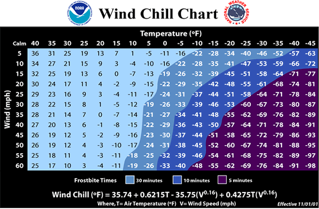
Extremely cold air comes every winter in at least part of the country and affects millions of people across the United States. The cold air, combined with brisk winds, can lead to dangerously cold wind chill values. The Wind Chill Index helps you determine when dangerous conditions develop that could lead to frostbite or hypothermia. It takes into account heat loss from the human body to its surroundings during cold and windy weather. The calculation utilizes wind speed in miles per hour and temperature in degrees Fahrenheit. For example, a temperature of minus 5 degrees occurring with a 20 mph wind gives a wind chill near minus 30 degrees. This means that your body will lose heat at the same rate as it would if the air temperature were minus 30 degrees with no wind. Wind Chill values near minus 25 degrees mean that frostbite is possible within 15 minutes.
Frostbite is the freezing of skin and the body tissue just beneath it. It first affects exposed body tissue where blood circulation may be limited such as your fingers, toes, nose and ears. To minimize frostbite, make sure all body parts are well covered. When frostbite starts, feeling is lost in the affected area and the frozen tissue will take on a white or pale appearance. If you suspect you are experiencing frostbite, hold the frostbitten area closely against warm skin to return blood flow and warmth to the affected area.
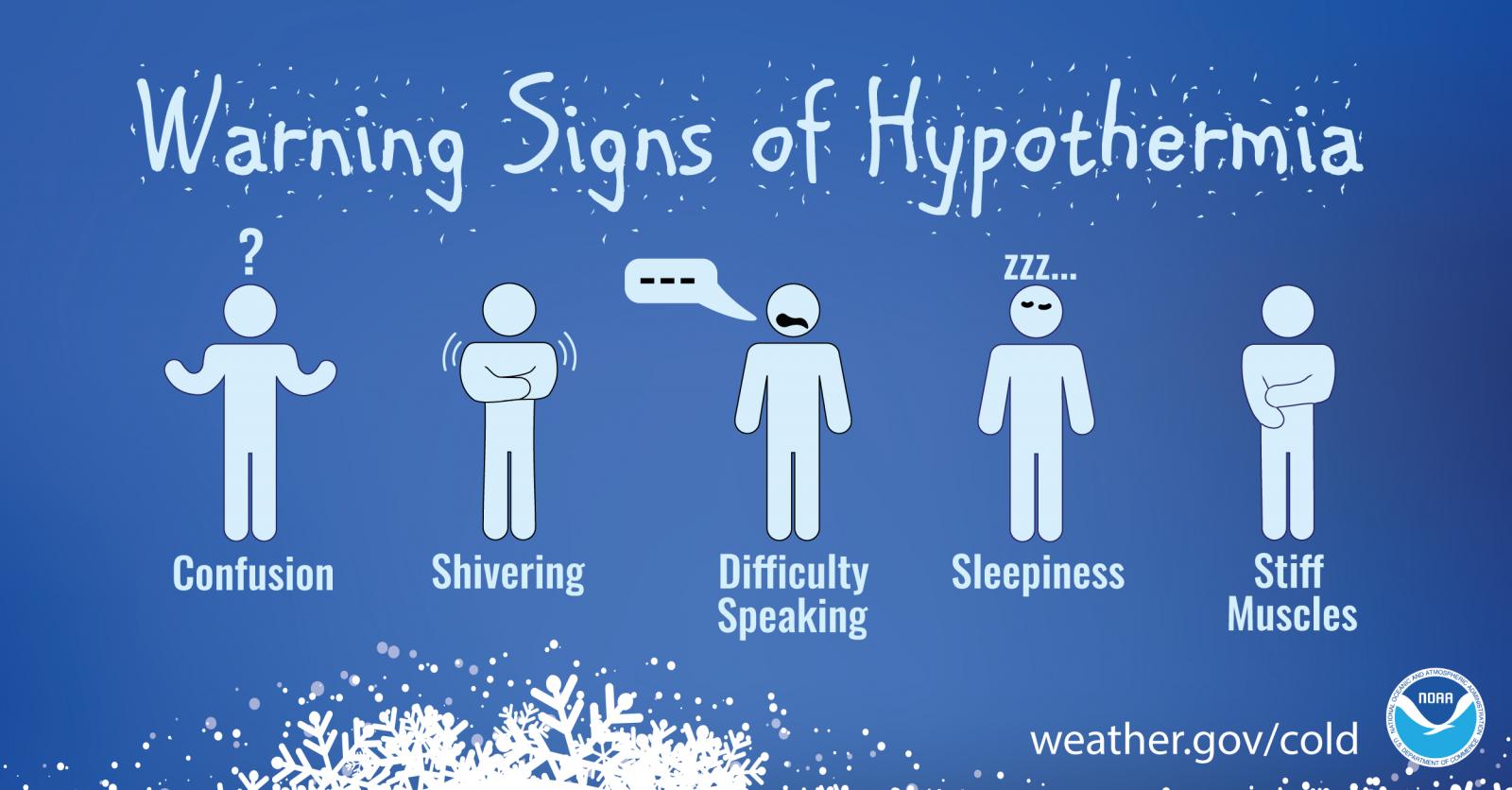
Hypothermia is a dangerously low body temperature and is the most common winter weather killer. When you hear of a hiker, climber, hunter or stranded traveler perishing from cold weather exposure, hypothermia was the cause. Most people are surprised to learn that hypothermia deaths can occur with temperatures between 30 and 50 degrees. If you or your clothing is wet, then hypothermia becomes even more likely.
Warning signs of hypothermia include uncontrollable shivering, memory loss, disorientation, slurred speech and drowsiness. Immediate medical attention should be given to victims suspected of suffering from hypothermia. If no help is available, the victim should be warmed slowly with warm liquids along with dry clothing and blankets.
The National Weather Service will issue wind chill advisories and warnings when a deadly combination of wind and cold air threaten. A Wind Chill Warning will be issued for the following wind chill temperatures:
Mountains...minus 35 degrees Fahrenheit or colder.
Lower Elevations...minus 25 degrees Fahrenheit or colder.
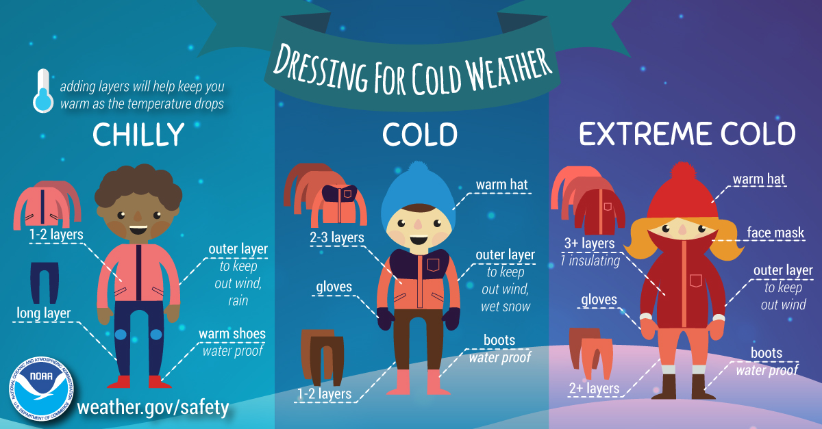
When cold weather threatens, follow these tips for survival:
Stay dry: Wet clothing results in much faster heat loss from your body. Wear waterproof insulated boots.
Stay covered: Wear mittens or gloves and wear a hat. At least half of your body heat is lost if your head is not covered.
Dress in layers: Trapped air between loose fitting clothing helps to insulate.
Stay informed: Have a portable NOAA Weather Radio or your cell phone nearby to keep you up-to-date with the latest forecasts and warnings. Use wind chill temperatures to guide you in dressing properly for the outdoors. On very cold days, minimize your exposure to the outdoors if possible.
Know the risk of avalanches and how to be prepared
Thousands of avalanches occur each winter in the mountains of Colorado. With the enormous popularity of winter sports in Colorado, this poses a risk to skiers, snowboarders, snowmobilers, and people traveling in the backcountry. On average 6 people die in avalanches in the state of Colorado every year. Anyone who travels into the high country in the winter should be prepared for avalanches and know how to avoid them.
The most important thing to know is how to get information on current avalanche conditions and be knowledgeable about avalanche safety. Check the Colorado Avalanche Information Center website at https://www.colorado.gov/avalanche/ for the current avalanche forecast and opportunities for training on avalanche safety. Go to the National Weather Service website https://www.weather.gov/ for the current weather forecast in your area. Knowing the current and future conditions will help you make good decisions in the backcountry. Know before you go!
A little information about avalanche safety can go a long way. Most avalanches occur during or just after snowstorms on slopes between 30 and 45 degrees. A significant snowfall may result in an unstable snowpack. Waiting at least 36 hours after a big snow or wind storm before you go into the mountains will allow for the snow to become more stable and less likely to avalanche. If you stay in valleys away from steep slopes, in stands of trees, or on low-angled terrain you can decrease the risk of being caught in an avalanche.
If you are a skier or snowboarder at a commercial ski area, the risk from avalanches is lower than in the backcountry. Ski patrols work to reduce the chance of an avalanche on open slopes. Respect the rules of the ski area and stay on open slopes and do not stray out of bounds or into closed areas. The avalanche risk is higher outside of the ski area boundaries. If you want to enjoy the great outdoors in areas prone to avalanches, you can reduce the danger by following a few simple rules:
Check the current avalanche forecast to get information on current and forecast avalanche conditions.
Check the latest weather forecast to see if conditions are likely to change while you are in the backcountry.
Never travel alone. Always have one or more companions. Even small avalanches can be fatal. If you are alone and get trapped, you may not be found until spring.
If crossing a slope that may be prone to avalanches, do it one person at a time. You want to minimize the impact on your party if an avalanche is accidentally released.
In avalanche country, all members of your party should carry avalanche rescue equipment including an avalanche beacon, shovel, and probe pole. This increases your chance of a successful rescue and finding your friends alive.
Take an avalanche class. This will help you better use the avalanche forecast, and teach you how to practice with your rescue gear.
The Colorado Avalanche Information Center Avalanche monitors and forecasts avalanche conditions in Colorado. You can get more information on avalanches, avalanche forecasts, and avalanche safety and request a safety class from the CAIC. Go to their website, https://www.colorado.gov/avalanche or call the center at 303-499-9650.
Winter Weather Preparedness Week continues through Saturday. Now is the time to get prepared for winter so you can safely enjoy the outdoors and travel safely when the snow flies.
WINTER WEATHER PREPAREDNESS WEEK IN REVIEW
It is common for Colorado to experience some powerful winter storms each year, including those that produce heavy snowfall, blizzards, and dangerous avalanche conditions.
The National Weather Service issues a variety of winter weather outlooks, watches, warnings, and advisories, covered earlier during this Winter Weather Preparedness Week. Safety tips were also passed along.
Before winter weather threatens this season, you should prepare a winter survival kit for your vehicle. When planning travel, check the latest weather forecasts and road conditions.
A valuable companion when heading out is a battery powered All-Hazards NOAA Weather Radio, the “Voice of the National Weather Service”. It provides you with the latest weather conditions and forecasts. You can pick one up at your local electronics or department store, or order one online.
For more information on winter weather safety, go to weather dot gov and select the SAFETY link at the top of the page, then click on the Winter Weather link.
Enjoy the great outdoors in Colorado this winter season, but always be prepared for the weather conditions!
Winter Preparedness - NOAA - National Focus
Watches and Warnings are issued by the National Weather Service for a variety of winter hazards. Make sure you have a way to receive warnings. The National Weather Service web pages are a great way to view weather hazards at www.weather.gov. NOAA Weather Radios are another great way to monitor the weather and receive watches, warnings and advisories and they can be found and most hardware or electronics stores.
Safety information, watches, warnings, forecasts, current conditions, radar, and much more information is available at your local National Weather Service web sites: