|
|
|
|
|
|
|
Sunday
Monday
Tuesday
Wednesday
Thursday
Friday
Saturday
Thunderstorm season is approaching...are you ready? The National Weather Service wants everyone to be part of a Weather-Ready Nation. Colorado is an annual host for tornadoes, flash floods, tornadoes, damaging hail, killer lightning and wind damage. Are you weather-ready? Now is the time to make sure you know how to stay safe when severe weather threatens. Therefore, the week of April 14th to 20nd has been designated is Colorado Severe Weather Awareness Week.
Watches and Warnings Every day of the year each National Weather Service office across the country is monitoring for severe weather. Each National Weather Service forecast office has a website, a Facebook page, and a Twitter feed where you can find vital information highlighting upcoming weather hazards. The hazardous weather outlook, a text product, highlights weather hazards seven days in advance.
If severe weather becomes likely within six hours, a watch will be issued, alerting you to the increased risk for severe weather. If you are in or close to the watch area you should plan where to go for shelter if severe weather occurs. If high wind is a threat, tying down or bringing loose objects indoors would be a wise move. If large hail is a threat, protecting your vehicle would be a good idea. Then, forecasters at the local National Weather Service forecast office will monitor satellite and radar data, and collaborate with severe weather spotters. Forecasters will issue warnings to alert you of the imminent severe weather threat. The warnings are sent out in many different ways in order to reach the most people possible. A warning is an urgent message telling you that severe weather or flooding is imminent or is occurring. Warnings are storm-based, and usually issued for an area smaller than a county.
Do not be caught off guard. Know how to receive watch and warning information, and know what to do when severe weather threatens. Specific safety information will be available each day of this Colorado Severe Weather Awareness Week. Tornadoes and Tornado Safety
This is Colorado Severe Weather Awareness Week, a time when the National Weather Service reminds you of the hazards associated with thunderstorms. Today’s topic is tornadoes. Colorado is no stranger to tornadoes. In fact, 12 years ago on May 22nd, 2008, a powerful tornado, rated an EF-3 on the Enhanced Fujita scale, moved through portions of northern Colorado. The tornado cut through Windsor, CO on its 39 mile path, leaving behind a path of destruction, at least 78 injuries, and one fatality. Damage estimates exceeded $100,000,000 from this tornado. While large tornadoes are not as common along the Colorado Front Range as they are across the Eastern Plains, they are possible given the right conditions. The location was not the only oddity with this significant tornado; the tornado moved from southeast to northwest. Only a small minority of all tornadoes move northwest. Also, the tornado formed just before noon, well before the usual time frame when tornadoes are most common. Tornadoes typically form during the afternoon to early evening hours across Colorado. The tornado threat in Colorado increases rapidly in May and continues through August. Ninety percent of Colorado tornadoes occur during this four month period, but tornadoes have been reported as early as February and as late as November. On average, Colorado experiences 53 tornadoes annually. Tornadoes have occurred in most areas of the state, but historically 95% of tornadoes occur along and east of Interstate 25 where heat and moisture in the lower atmosphere are often more abundant. Tornadoes can occur at every hour of the day, but most occur between 1pm and 8pm. Across the country, about 90% of tornadoes are considered weak with winds less than 110 mph. About 10% of tornadoes are considered strong with winds up to 165 mph. Strong tornadoes are responsible for nearly 30 percent of tornado deaths. Violent tornadoes account for only 1% of all tornadoes, but they result in nearly 70 percent of all tornado fatalities because they destroy much of what is in their path. An easy phrase to remember for tornado safety is to Get In, Get Down, and Cover Up. Get inside a sturdy building, get down to the lowest floor or most interior room, and cover your head. The best option for tornado safety is to be inside a well-built structure within a basement, safe room or underground storm shelter. If none of these options are available, move to a hallway or a small interior room on the lowest floor such as a closet or bathroom. A room without windows is best. Cover yourself with blankets or get under a sturdy piece of furniture because the greatest risk of injury from tornadoes is from flying debris and structural collapse. Abandon modular homes and mobile homes as they offer little to no protection from tornadoes. Most tornadoes can destroy even tied-down mobile homes. Approximately 50 percent of all tornado fatalities are the result of people sheltering in a mobile home. If a tornado approaches, seek safety in a nearby building or storm shelter. A neighbor or family member’s house, a community storm shelter, or other local buildings all provide better shelter. Remember to get out! If you are driving in open country and see a tornado, do not try to outrun a tornado as tornadoes can move up to 60 miles per hour. Instead, simply drive away from the tornado path at a right angle if time permits. Do not take shelter beneath a highway overpass. If a tornado is fast approaching with little time to react, pull over into a ditch. Either remain buckled in your vehicle while crouching down below window level, or abandon your vehicle and lie down in a low area away from your vehicle and protect your head. If you are caught outside and cannot find a safe shelter, crawl into a culvert or lie down in a narrow ditch and cover your head. Remember these are poor, last-minute options; the worst place to be when a tornado threatens is outside in the midst of flying debris. Heavy rain can also produce flash flooding, putting you in further danger when taking shelter in a culvert or ditch. You can get the latest weather forecasts and severe weather watches and warnings from a local NOAA All-Hazards Weather Radio station, your local radio or TV stations, your cell phones, and on the Internet at weather.gov. For more complete information on tornadoes and tornado safety visit weather.gov/boulder . In the news headlines section, click on the Colorado Severe Weather Awareness web link and choose the Tuesday statement. If a tornado threatens your location, remember to get in, get down, and cover up! Flash Flood Safety
Major flooding in September 2013 resulted from over eight inches of rain that fell over a large area from northern Jefferson County to the Wyoming border. This rain occurred in a number of creeks and rivers, causing considerable flash flooding. Runoff from area streams combined to cause major flooding along the South Platte River. Mitigation is still ongoing to repair flood damage along the creeks and rivers in and near the foothills from Larimer County to El Paso County and along the tributaries to the South Platte River. Flash flooding refers to a dangerous sudden rise in water along a creek, river, or a normal dry land area. Flash floods result from heavy rainfall, sudden breaks in river ice jams, and dam or levee failures. Flash floods can occur within a few minutes or hours, and can move at surprisingly high speeds, striking with little warning. Flash floods are quite destructive because of the force of the moving water, and the debris that accumulates in flood waters, such as trees and boulders, which can destroy roadways, bridges, and buildings. Other complications in Colorado are an increased flash flood threat in areas of recent wildfires. Heavy rain on burn scars, even for a brief amount of time, can cause flash flooding and debris flows. Burn scars are at higher risk for flooding for as much as five years after the wildfire. Residents in and near burned areas should plan ahead on response actions for flooding. The National Weather Service will discuss flood and flash flood potential in daily hazardous weather outlooks and in the weather story on National Weather Service websites. On days with a high threat of flooding you may hear...
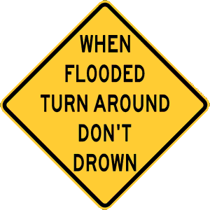
Nearly half of all flash flood fatalities are vehicle related. Do not enter a flooded roadway, instead Turn Around, Don’t Drown. In rapidly rising waters, backing up away from water may be safer. One or two feet of water will carry away most vehicles, and you also cannot tell if the road is damaged beneath moving water.
Colorado Severe Weather Awareness Week continues through this Saturday. Damaging straight-line winds and large hail are major weather risks in Colorado
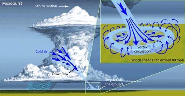
Tornadoes are often the headline story, but damaging straight-line winds can also be life threatening. These winds are caused by an area of rain cooled air that as it falls towards the ground will accelerate downward. Depending on how dry or moist the air beneath the storm is, this rain cooled air can create either a wet or dry burst of intense wind at the surface.
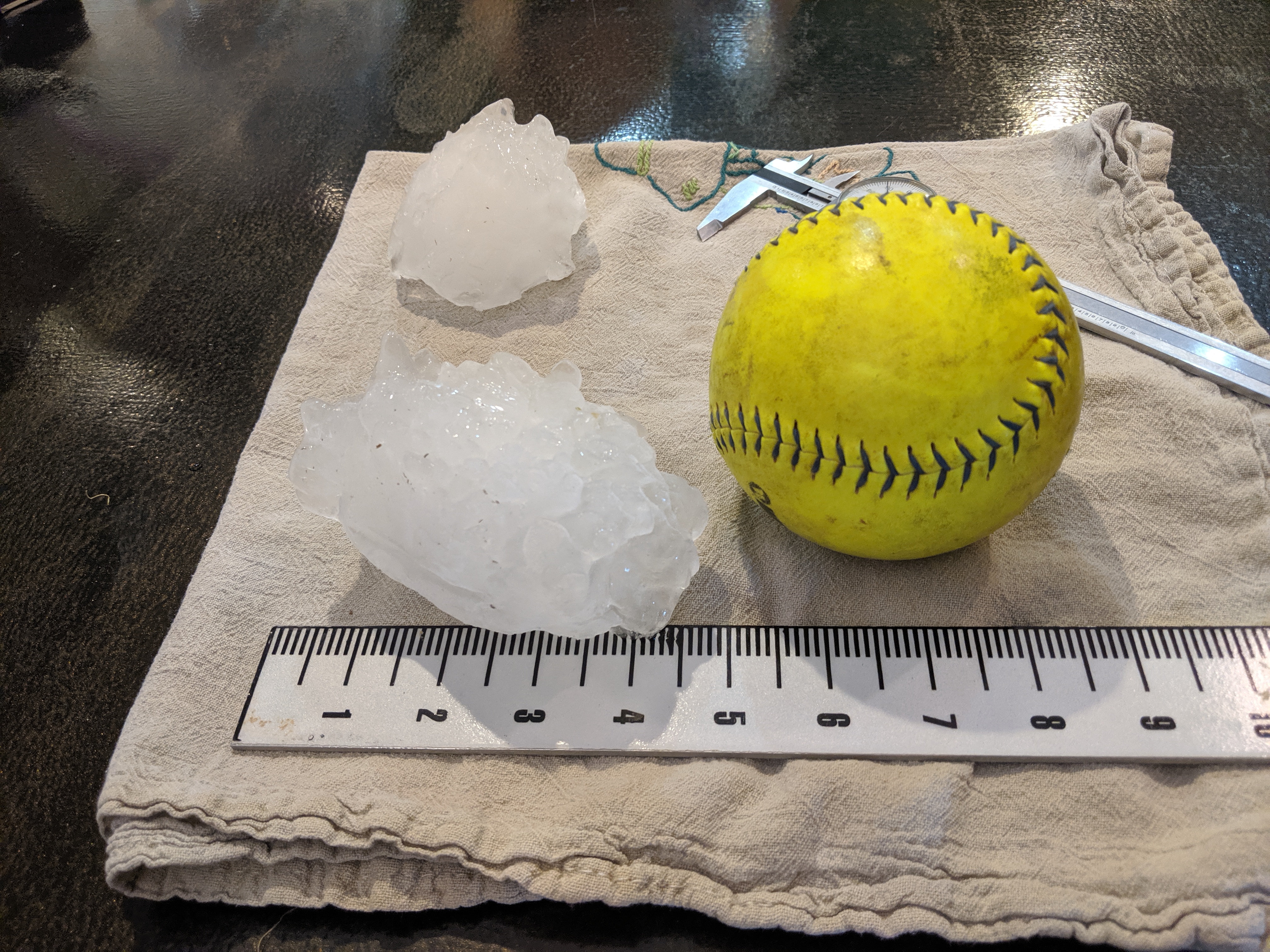
These bursts of wind are defined by the size of the area in which they impact. Weather forecasters call these winds microbursts if they are less than 2 1/2 miles across and macrobursts if they are greater than 2 1/2 miles across. This process, in extreme cases, can result in wind speeds exceeding 100 mph. These downbursts of cool air can be life threatening to pilots, and can cause extensive damage, injuries, and deaths at ground level. Try to get indoors during all storms, because high winds can suddenly develop, causing things on the ground to become swiftly moving missiles...that can injure or kill. Hail often occurs in Colorado. Hail forms within storms as liquid water freezes in the cold mid and upper levels of the storms. The hailstones are kept aloft by strong updraft winds for a time, and then cascade to the ground. In Colorado, hailstones vary from pea size, around 3/8 of an inch in diameter, to softball size, around 4 1/2 inches in diameter. The state record hail stone fell on Bethune Colorado on August 13 2019. Measuring in at 4.38 inches, it had a circumference of almost 13 inches and weighed over half a pound. Read more about how the record was certified and the weather that created the hail here.
Colorado's record hail stone fell on Bethune CO August 13, 2019 Hailstones can do tremendous damage to crops, either as large hailstones, or as a large volume of small hailstones that accumulate to a depth of several inches. Large hail damages vehicles and buildings, and can be life threatening to animals and people. The National Weather Service issues severe thunderstorm warnings for winds of 58 mph or higher or for large hail one inch in diameter or larger. When you hear of a When thunderstorms threaten you this severe weather season, tune to NOAA Weather Radio All Hazards. Wherever you are during threatening weather, plan out the actions you would take if severe weather were to strike. When Thunder Roars, Go Indoors!
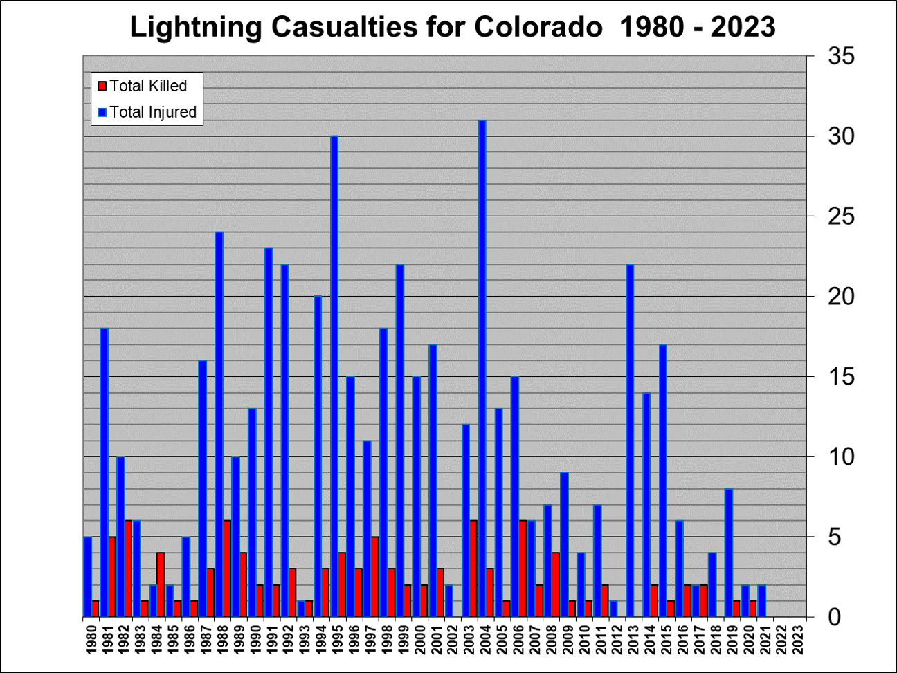
Thunderstorms produce some of the most dangerous weather on Earth, including tornadoes, flash floods, large hail, and destructive straight-line winds. However, the most dangerous aspect of thunderstorms in Colorado is usually lightning. Lightning usually kills and injures more people in Colorado than any other thunderstorm hazard. From 1980 through 2019, lightning has killed 99 people and injured 485 people in Colorado.
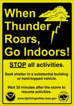
In addition to producing human casualties, lightning also ignites most forest and rangeland fires in the Centennial State. Many of these wildfires occur when lightning is generated from thunderstorms which produce little or no rainfall. This type of lightning is referred to as dry lightning. The safest thing for you to do, if you are outside and lightning or thunder begins to occur, is to immediately get inside a substantial fully-enclosed building such as a house, a business or a church. Metal-topped cars and trucks also offer excellent protection from lightning. Once inside a substantial building or metal-topped vehicle, keep all windows and doors closed, and do not touch any metal inside the vehicle. It is then recommended that you wait at least 30 minutes from the last rumble of thunder before returning outside. A recent lightning safety study has shown that 95 percent of the people who were struck by lightning while outdoors had a nearby substantial building or vehicle nearby. Remember, there is no safe place outdoors when lightning is occurring. Do not seek shelter under picnic shelters, sports dugouts, porches, trees, carports or tents. These types of structures are not safe when lightning is occurring. Once inside a substantial building, stay off corded telephones and away from electrical appliances since the electrical discharge can travel along the telephone lines and electrical wires to produce fatal results. Stay away from water including showers, tubs, and sinks. Even indoor swimming pools are not safe when lightning is occurring. It is also recommended that you unplug sensitive electronics such as computers when lightning is expected to occur nearby. The best defense to protect yourself against a lightning strike is to plan ahead and avoid being caught where you might be vulnerable. Check the weather forecasts prior to venturing out, especially if you are heading into the mountains. Plan your outdoor activities for early in the day before thunderstorms typically develop. Stay tuned to All-Hazards NOAA Weather Radio and check the National Weather Service forecasts at www.weather.gov. It is very important that all sports leagues and other outdoor groups have a lightning response plan that is understood and consistently applied for the safety of the participants. Part of the plan would include a designated weather watcher at each outdoor event with the authority to postpone or cancel the event due to the threat of lightning. Remember, if thunderstorms threaten, seek shelter in a substantial fully-enclosed building or in an enclosed metal-roof vehicle. For more information on lightning safety, please check out the web site www.lightningsafety.noaa.gov For more information about lightning in Colorado, please go to the Colorado Lightning Resource webpage.
Severe Weather Awareness Week in Review Severe Weather Awareness Week in Colorado concludes today. During the past week we have presented information and safety rules for tornadoes, lightning and wildfires, floods and flash floods, straight-line thunderstorm winds, hail, and our warning programs. We will now review some of the most important safety rules in our effort to promote a Weather-Ready Nation. Be weatherwise by staying informed on expected weather in your area. The National Weather Service is typically aware of the potential for severe weather many hours or even days before any severe weather watches or warnings are issued, providing forecast products to heighten your awareness. A Weather Story product is posted each day on National Weather Service internet pages and Facebook pages which includes graphics and text on possible hazardous weather expected within the next 7 days. A Hazardous Weather Outlook is also issued daily with information on possible hazardous weather through the next seven days. A Watch is issued when conditions for severe weather or flooding become possible. A Warning is then issued when life threatening weather or flooding are imminent or occurring. Tornadoes... The best way to protect yourself from tornadoes is to have a plan of action. The safest place to be if a tornado approaches is in a basement or safe room within a well-built structure, or in an underground storm shelter. If none of these options are available, move to a hallway or a small interior room on the lowest floor, usually this is a closet or bathroom. Get under a heavy piece of furniture or in a bath tub and cover yourself with blankets. Remember, the greatest risk of injury from tornadoes is from flying debris. Modular homes and mobile homes, even those tied down, offer little protection from tornadoes. If a tornado approaches, leave those locations and seek safety in a nearby sturdy building or storm shelter. If you are driving in open country and see a tornado, if time permits, the best thing to do is simply drive away from the tornado path. Do not take shelter beneath a highway overpass. Wind speeds may actually be higher in those areas and often become collection points for debris. If you are caught outside and cannot seek shelter inside a sturdy structure, crawl into a culvert or lie down in a narrow ditch or ravine and cover your head. But remember that the worst place to be when a tornado threatens is outside in the midst of flying debris. Lightning... Lightning usually kills and injures more people in Colorado than any other thunderstorm hazard. Lightning also ignites most wildfires in Colorado. The best defense to protect yourself against a lightning strike is to plan ahead and avoid being caught where you might be vulnerable. Check weather forecasts prior to venturing out, especially if you are heading into the mountains. Plan outdoor activities early in the day before thunderstorms develop. If thunderstorms threaten, seek shelter in a substantial fully-enclosed building or in an enclosed metal-roof vehicle, making sure all windows and doors are closed. Never seek shelter under an isolated tree. During thunderstorms, stay off corded telephones, away from electrical devices, and away from plumbing. Also get out of swimming pools and lakes when lightning is nearby. You should wait at least 30 minutes after the last sound of thunder or flash of lightning before resuming outdoor activities. Remember…When Thunder Roars, Go Indoors! Floods and Flash Floods... When flooding or flash flooding is possible, you should remain alert and be ready to quickly evacuate to higher ground or climb to safety. Flash floods often occur suddenly and without warning. You need to follow some basic flood safety rules...
At least half of all flash flood fatalities are vehicle related. While driving your automobile or truck, look out for flooding at highway dips, bridges and low areas. Two feet of moving water will carry away most vehicles. Be especially cautious at night when it is difficult to see flood dangers. Never attempt to drive across a flooded road, instead Turn Around, Don’t Drown! Strong Straight-Line Winds... Straight-line winds from thunderstorms, including microbursts, can become quite strong, even reaching speeds in excess of 100 mph in extreme cases. When thunderstorms approach, high winds can suddenly develop, causing things on the ground to become swift moving airborne missiles with a potential force to injure or kill. As with any thunderstorm, seek shelter before the storm arrives. Hail... Large hail can pose a danger to animals and people. Hail also produces considerable damage to crops and personal property each year in Colorado. Again, get indoors before thunderstorms arrive. A fall of small hail can suddenly change to a fall of very large ice missiles which can injure or kill. Make efforts to protect personal property before storms threaten. Warning Notification… When thunderstorms threaten, tune to All-Hazards NOAA Weather Radio, monitor weather apps, or your local radio or television stations. Also check the internet web site from the National Weather Service office serving your area. If you have a newer cell phone you should automatically receive tornado and flash flood warnings on your phone if you are in the area of the warning. During threatening weather days, plan the actions you will need to take so that you will be prepared if dangerous weather conditions actually develop. Please heed the severe weather safety guidelines and enjoy the great outdoors! |
|
|
|
|