National Weather Service United States Department of Commerce
Click to change Forecast Type:
 
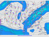
Click in map for forecast. Left click (+) to toggle layers. Enter Lat/Lon for point Fcst
Instructions: Left mouse click to obtain tabular forecast for clicked area. To zoom, use mouse wheel or upper left hand controls. The default Forecast Type is the FireWx Tabular Table. To change the Forecast Type, use the forecast type pull down in the upper left corner. Use the Lat/Lon entry box in the upper right to enter a specific point and then click Go.
Regional WX Radar Regional Radar
Radar Loop Regional Satellite
Surface WX Analysis Surface Analysis
NASA SPoRT LMA Lightning Plot NASA Lightning
Severe Weather Outlook         Severe Wx Outlook
Rainfall Outlook      Rainfall Outlook
Rainfall Outlook   River/Hydro
NE CO WX Impact Display     NE CO WX Impact's
Outlooks
Day1 Enhance
Upper Air
Day1 Hail
Soundings
Day1 Tor
Short Range Ensemble
Day 2 Otlk
SREF Plumes
Excessive Rnfl
SSEO
Day 2 QPF
Mesoscale Analysis
Day4-5
Climatology
Storm Prediction Center:  Advanced Tools
Upper Air
Upper Air
Soundings
Soundings
Short Range Ensemble
SREF Plumes
SREF Plumes
Storm Scale Ensemble
SSEO
Analysis
Mesoscale Analysis
Climatology
Climatology
Latest Forecasts Observations/Rainfall Discussions/Safety