|
 A radar loop of the supercell that caused $2.3B in damage across metro Denver on May 8, 2017 |
Photos & Video
 |
 |
 |
 |
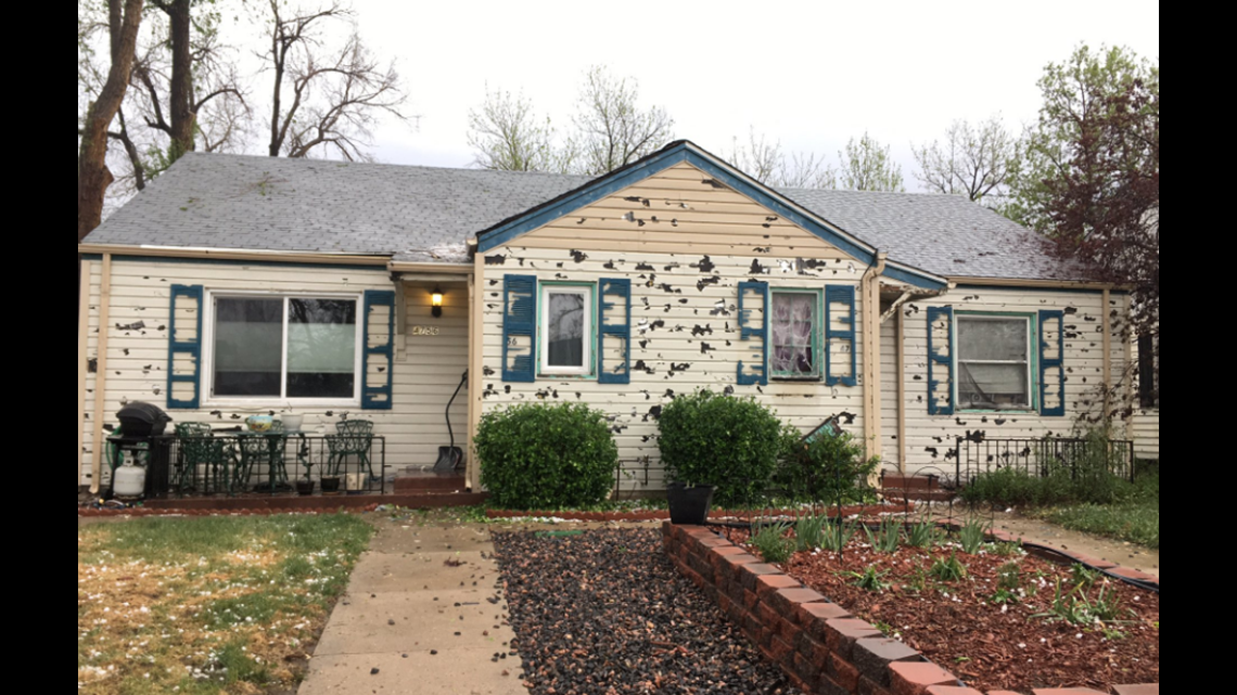
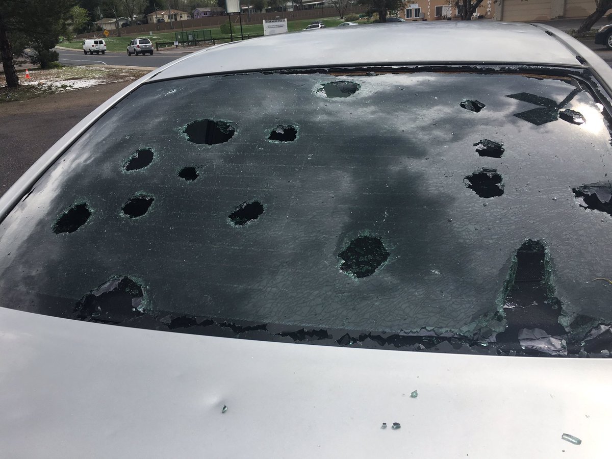
| Typical damage to houses in the path of the hailstorm. Via 9news. | Up to baseball size hail smashed through car windows and devastated the cars body. Via Twitter |
One of the larger hailstones to fall on May 8, 2017 Via Twitter |
Downtown Denver near the tail end of the storm. Hail accumulated several inches deep Via Twitter |
Radar
 |
 |
 |
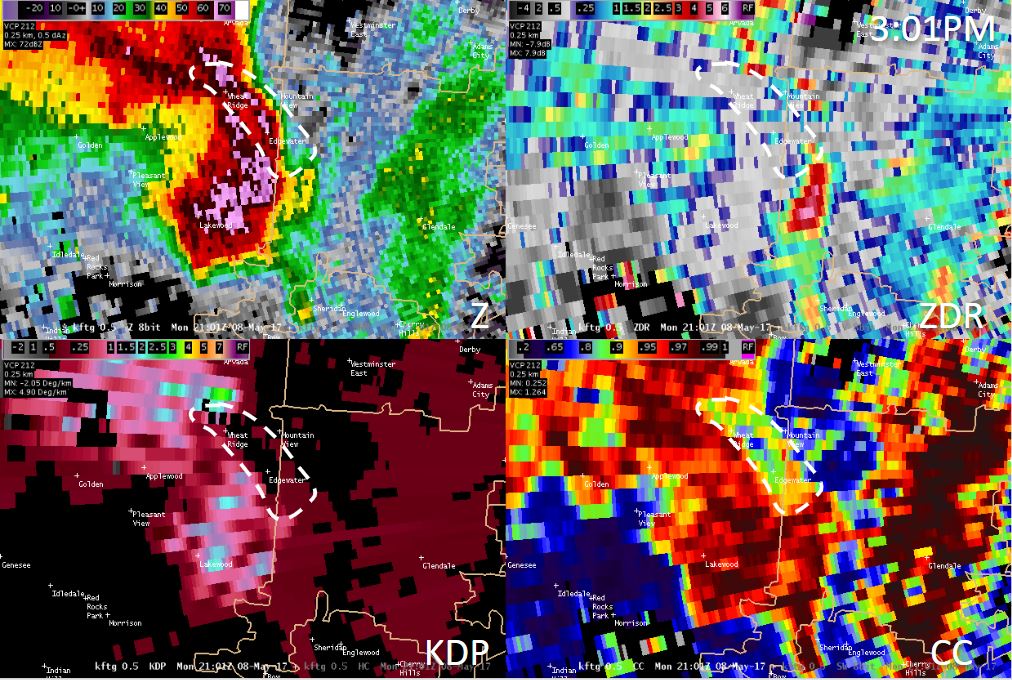 |
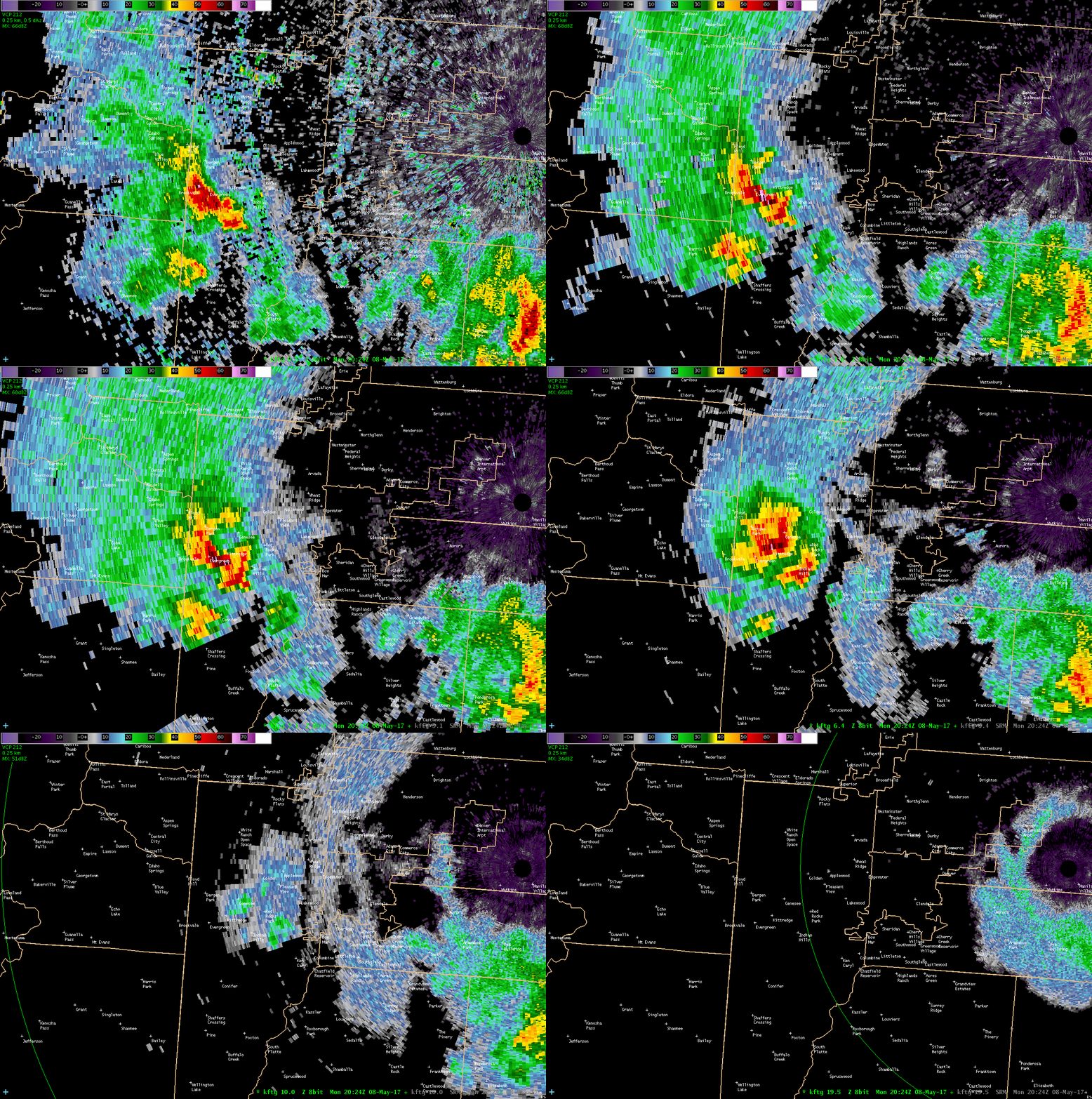
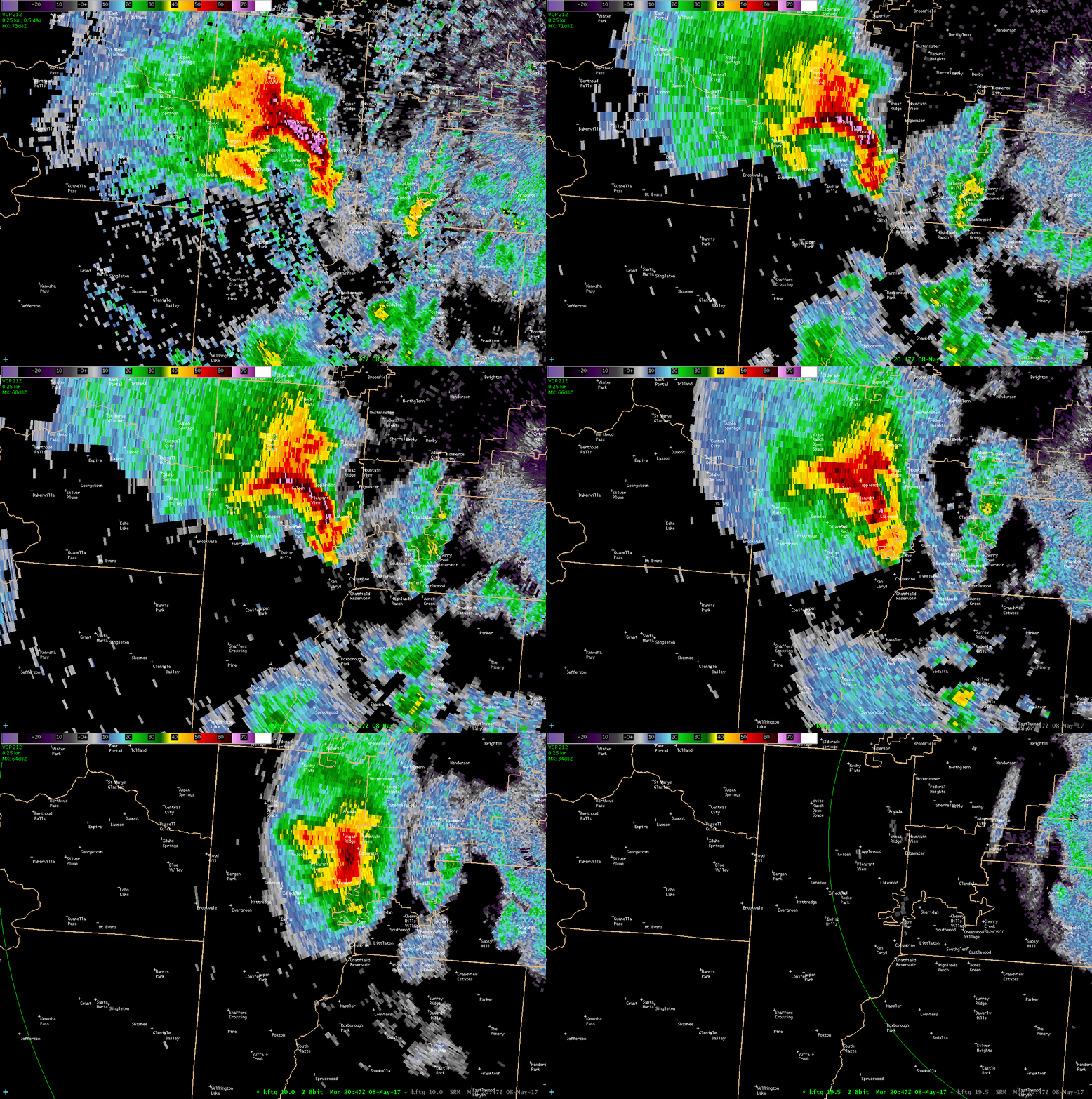
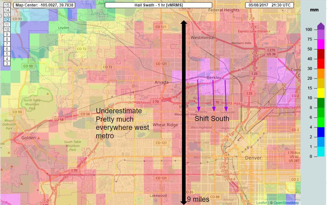
| KFTG All Tilts Reflectivity from May 8, 2017, at 2:24 PM. Each successive scan shows a higher elevation angle and thus greater height above the ground. This shows a developing supercell over Evergreen with a significant Bounded Weak Echo Region (BWER) just west of Genesee. Severe hail to the size of half dollars was already occurring. | KFTG All Tilts Reflectivity from May 8, 2017, at 2:47 PM. Each successive scan shows a higher elevation angle and thus greater height above the ground. The storm has intensified over Jefferson County from Golden to Wheat Ridge and south to Lakewood. The BWER is over 5 miles wide at this point. | Multi-Radar Multi-Sensor (MRMS) hail size estimation for May 8, 2017. Across Wheat Ridge west to the Colorado Mills Mall area in Golden, the hail size was vastly under estimated at right around 1". Numerous reports and videos had the hail 2-2.75" in diameter across that area. Dark red/burgundy pixels indicate about golfball size hail (1.75" diameter). The striking thing about these data is that the golfball and larger hail swath was 9 miles wide north to south. That was a major reason why the damage costs were so extreme. | KFTG Reflectivity (top left), Differntial Reflectivity (top right), Correlation Coefficient (bottom right), and Specific Differential Phase (bottom left) from May 8, 2017, at 3:01 PM. The white dashed polygon shows the extent of the giant hail based on radar data. The most impressive feature of this image is the Correlation Coefficient (CC) dropping to values normally associated with non-precpitation echo. In this case, it's giant hail that causes the major drop in CC. |
Storm Reports
Businesses and homes sustained holes in siding along with broken windows and torn screens. The high cost incurred from the storm was due to a number of factors including: the size of the hail, the densely populated area, the time of day, the escalating costs to repair high-tech cars, and more expensive homes. Colorado Mills Mall in Lakewood was severely damaged after hail busted skylights and caused flooding inside stores. The common areas and tenant spaces suffered substantial water damage. Extensive damage to electrical systems, mechanical systems, including HVAC and lighting, kept the mall closed until November 2017. In Lakewood, the loss in sales tax was projected to be about $350,000 per month, which was 3 to 4 percent of the city's monthly budget. Prestige Imports in Lakewood which sells high end automobiles like Audis and Porches, estimated 250 to 300 vehicles were impacted by the storm. Some of those vehicles were valued at nearly $200,000 each. Significant damage was reported at Lutheran Medical Center after a hailstorm tore through Wheat Ridge. The hospital building and some of the medical office buildings sustained broken windows. The storm also hit the office of the Denver Federal Center in Lakewood, which includes the Colorado Bureau of Investigation. The offices were flooded, several cubicles destroyed, and even some ceiling tiles fell off. The storm damage prompted school officials to close all thirteen Adams 12 Five Star schools in Commerce City and Beach Court Elementary school in Denver. Most of the schools in the Adams 12 Five Star District are at least 50 years old and sustained flood damage. Large hail damaged an apartment building near Regis University, shattered windows and punctured the siding on the west-facing side of the building.
| Location | County | Date | Time (MDT) | Type | Hail Size |
| IDLEDALE | JEFFERSON CO. | 05/08/2017 | 14:30 | Hail | 1.00 in. |
| PLEASANT VIEW | JEFFERSON CO. | 05/08/2017 | 14:40 | Hail | 1.25 in. |
| EDGEWATER | JEFFERSON CO. | 05/08/2017 | 14:45 | Hail | 1.75 in. |
| LAKEWOOD | JEFFERSON CO. | 05/08/2017 | 14:48 | Hail | 1.25 in. |
| PLEASANT VIEW | JEFFERSON CO. | 05/08/2017 | 14:50 | Hail | 2.00 in. |
| LAKEWOOD | JEFFERSON CO. | 05/08/2017 | 14:52 | Hail | 1.00 in. |
| GOLDEN | JEFFERSON CO. | 05/08/2017 | 14:52 | Hail | 1.75 in. |
| EDGEWATER | JEFFERSON CO. | 05/08/2017 | 14:52 | Hail | 2.00 in. |
| PLEASANT VIEW | JEFFERSON CO. | 05/08/2017 | 14:53 | Hail | 1.75 in. |
| LAKEWOOD | JEFFERSON CO. | 05/08/2017 | 14:55 | Hail | 1.00 in. |
| (BKF)BUCKLEY AIR FORCE BASE | ARAPAHOE CO. | 05/08/2017 | 14:57 | Hail | 1.50 in. |
| ARVADA | JEFFERSON CO. | 05/08/2017 | 15:00 | Hail | 0.88 in. |
| EDGEWATER | JEFFERSON CO. | 05/08/2017 | 15:03 | Hail | 1.75 in. |
| DENVER | DENVER CO. | 05/08/2017 | 15:04 | Hail | 2.00 in. |
| EDGEWATER | JEFFERSON CO. | 05/08/2017 | 15:04 | Hail | 2.50 in. |
| DENVER | DENVER CO. | 05/08/2017 | 15:05 | Hail | 1.00 in. |
| EDGEWATER | JEFFERSON CO. | 05/08/2017 | 15:05 | Hail | 2.75 in. |
| WHEAT RIDGE | JEFFERSON CO. | 05/08/2017 | 15:05 | Hail | 1.75 in. |
| DENVER | DENVER CO. | 05/08/2017 | 15:06 | Hail | 2.50 in. |
| EDGEWATER | JEFFERSON CO. | 05/08/2017 | 15:09 | Hail | 1.00 in. |
| (BKF)BUCKLEY AIR FORCE BASE | ARAPAHOE CO. | 05/08/2017 | 15:15 | Hail | 1.25 in. |
| DENVER | DENVER CO. | 05/08/2017 | 15:15 | Hail | 1.00 in. |
| DENVER | DENVER CO. | 05/08/2017 | 15:15 | Hail | 1.00 in. |
| DENVER | DENVER CO. | 05/08/2017 | 15:16 | Hail | 1.75 in. |
| DEER TRAIL | ARAPAHOE CO. | 05/08/2017 | 15:20 | Hail | 2.00 in. |
| DENVER | DENVER CO. | 05/08/2017 | 15:20 | Hail | 1.75 in. |
| FEDERAL HGT | ADAMS CO. | 05/08/2017 | 15:25 | Hail | 1.00 in. |
| BRIGHTON | ADAMS CO. | 05/08/2017 | 15:27 | Hail | 1.00 in. |
| DENVER | DENVER CO. | 05/08/2017 | 15:27 | Hail | 1.50 in. |
 |
Media use of NWS Web News Stories is encouraged! Please acknowledge the NWS as the source of any news information accessed from this site. |
 |