Overview
|
A slow moving and complex storm system affected Colorado from November 5th through November 9th. In some locations of east central and southeast Colorado, historic amounts of snow fell. Snow began to fall on the evening of November 5th, with periods of moderate to heavy snow then affecting the region through the early morning hours of November 9th. There were several waves of heavier snowfall, the first wave impacting the Southern Front Range Foothills, Palmer Divide, and adjacent plains through Lincoln and Washington Counties from the evening of the 5th through most of the 6th. Denver metro was on the northern edge of this first round, but temperatures were cold enough for some travel impacts on the morning of the 6th. After a brief lull on the evening of the 6th, another round of heavy snow occurred across the Palmer Divide area and adjacent plains, including Lincoln County and the I-70 Corridor east of Denver in the early morning and daylight hours of November 7th. Interstate 70 and numerous highways in east central and southeast Colorado were closed for an extended period of time due to this prolonged period of heavy snow. Rural roads were blocked by the depth of the snow, as snow had already accumulated to nearly 2 feet deep. And the storm wasn't done yet, and in fact in many cases the heaviest snow was yet to fall with the final wave of the storm. This last round of heavy snow developed in the morning hours of the 8th, and continued through the early morning hours of the 9th. Additional accumulations during this period topped a foot of snow over the far southeast portions of Denver Metro through much of rural Arapahoe, eastern Douglas, and Elbert Counties. This round of snow was also very heavy and wet, and resulted in scattered power outages. Around 30,000 customers were without power in the Denver metro area on the morning of the 9th. Meanwhile, major interstates (I-70 east of Denver) and most highways remained closed in east central Colorado. It took days to open some rural roads. Storm total snowfall amounts from 24" to 36" fell across the southern Foothills, Palmer Divide and across the east central plains. Local amounts exceeding 40" fell across portions of Elbert and northern Lincoln Counties, where this storm recorded the second largest snowfall totals in recorded history, second only to the early November, 1946 Snowstorm. Snowfall amounts over the Denver Metro area ranged from 12" to 24" with the highest amounts over the eastern and southern suburbs, but some melting occurred during this ~90 hour storm event. Only a few inches of slushy wet snow fell farther north, including Longmont, Fort Collins, Greeley, Fort Morgan, and Sterling. |
Deep snow on the roads November 8th. Photo courtesy of Douglas County Sheriff. |
Photos
 |
 |
.jpg) |
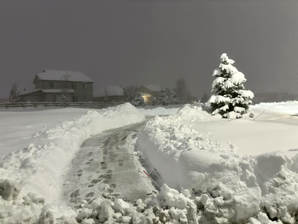 |
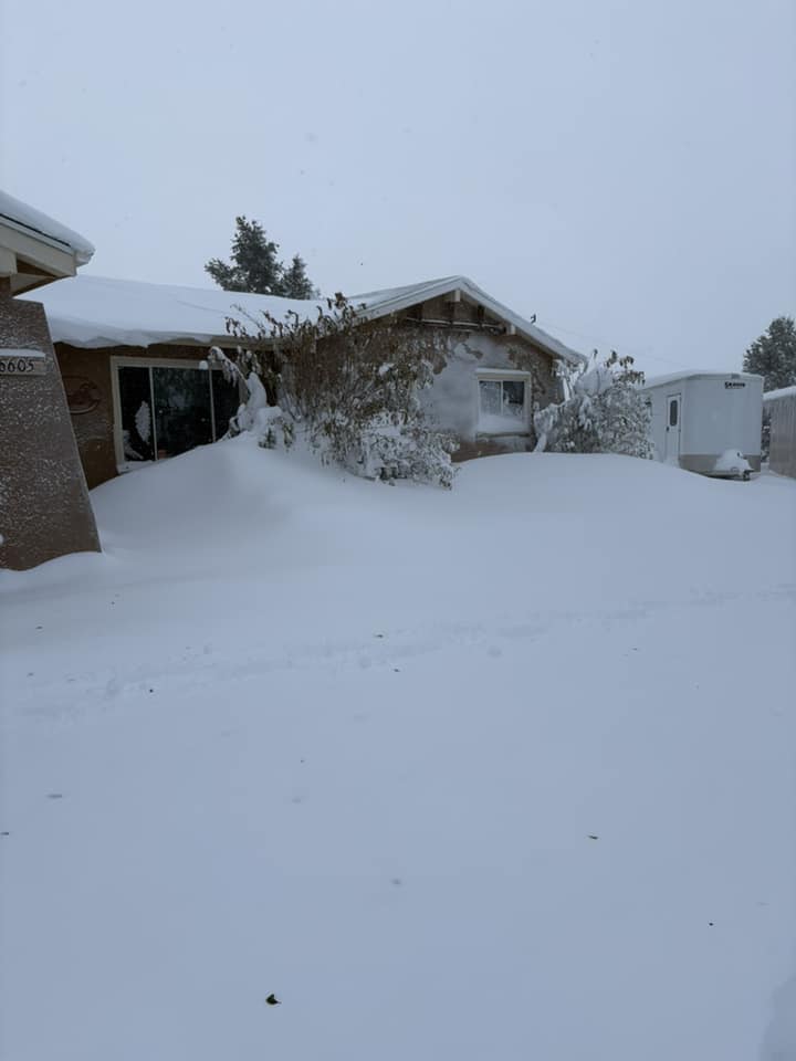
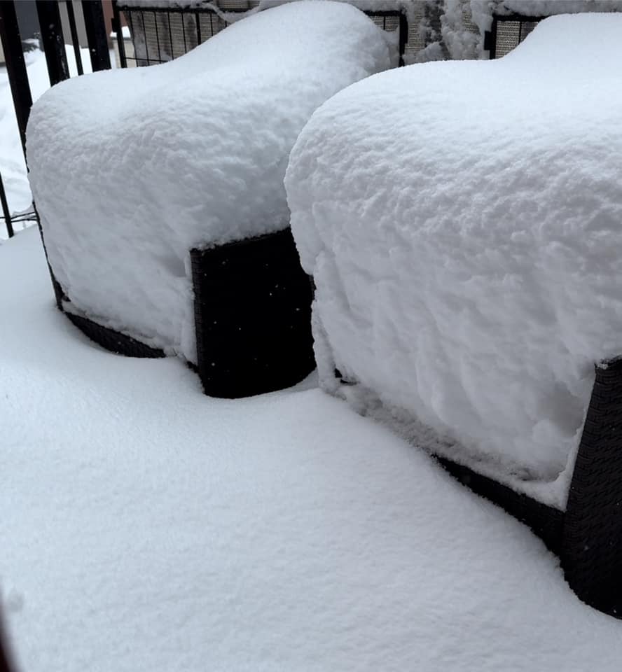
| Deep snow in Elbert, CO. Photo courtesy of Jeanne Sharpe. | Patio chairs in Parker, CO on the morning of November 9th. | Horse viewing the deep snow near Kiowa, CO. Photo courtesy of Veronica Selz. | Deep snow in the wee morning hours of November 9th in southeast Aurora, CO. Photo courtesy of Sarah Gentile. |
 |
 |
 |
|
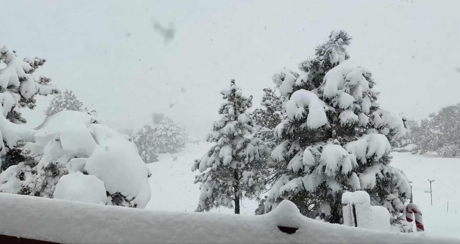
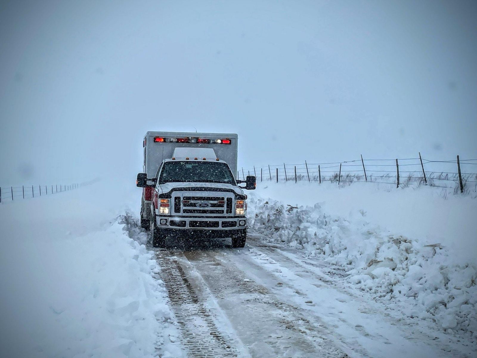
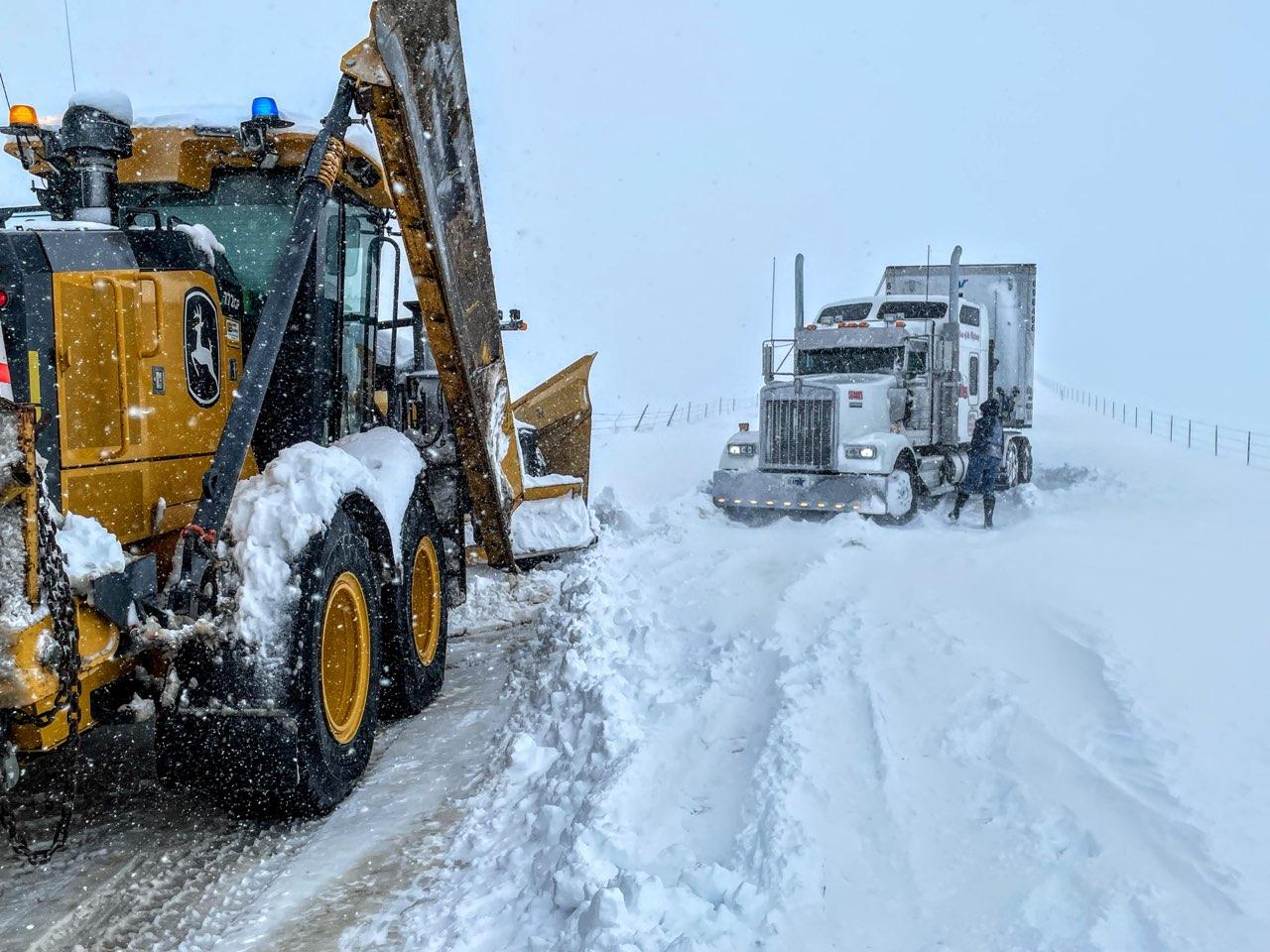
| Heavy snow early morning November 9th, east of Parker, CO. Image courtesy of Nick Smego. | Rescue vehicles coming to aid through deep snow. Photo courtesy of Elbert County OEM. | Large equipment assisting with recovering a semi-truck. Photo courtesy of Elbert County OEM. |
Radar & Satellite
.gif) |
 |
.gif) |
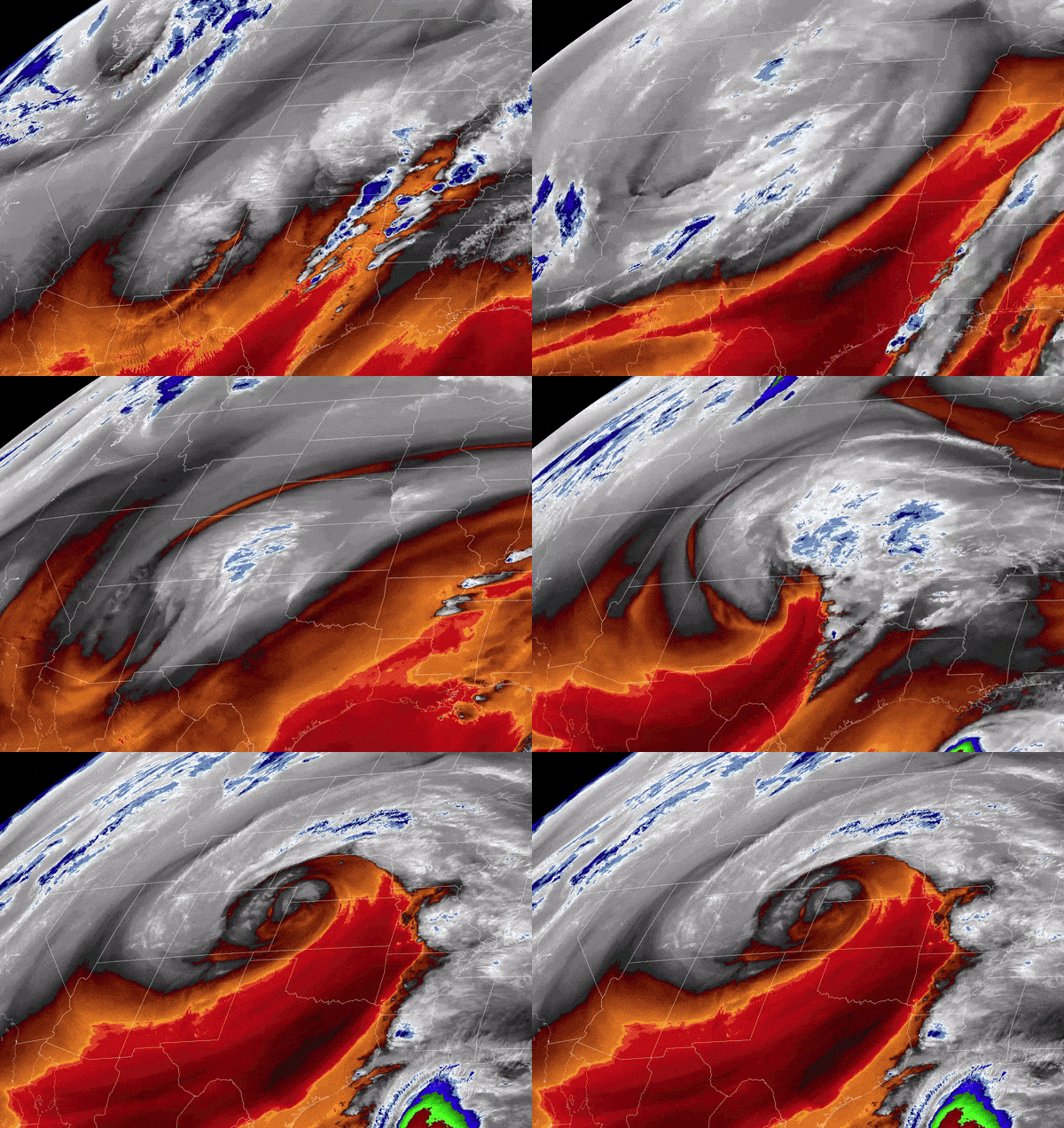 |
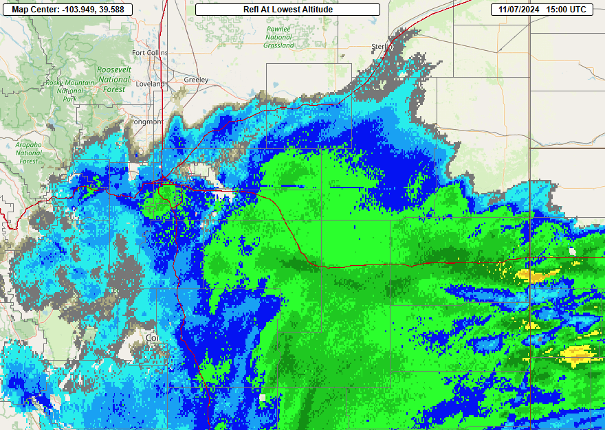
| First wave of snow as shown in radar imagery (5 pm November 5 - 11 pm November 6) | Radar imagery at 8 am November 7th, in the middle of the second round of heavy snow | Radar showing the last but most widespread wave of precipitation (12 am November 8 to 11 am November 9) | Satellite loop from Tuesday, November 5th through Saturday morning, November 9th. |
Storm Reports
Observed Snowfall across Colorado from November 5th through November 9th, 2024
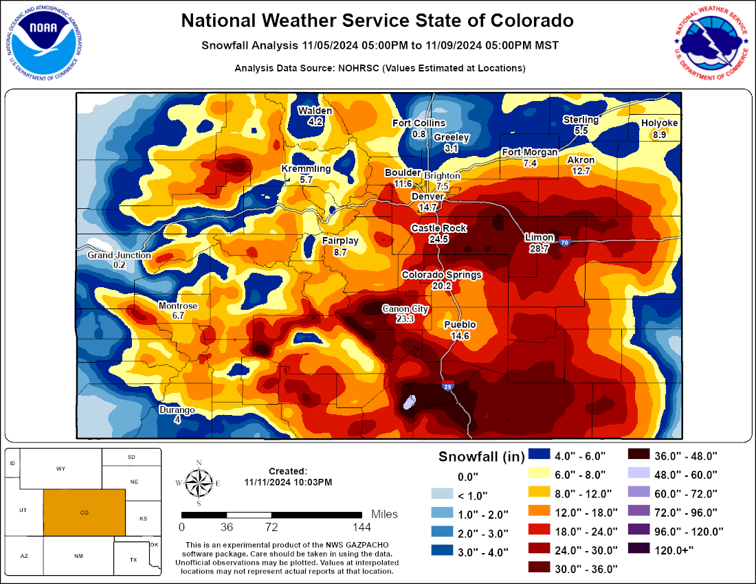
List of Snowfall Reports by County
...SNOWFALL REPORTS... Location Amount Time/Date Lat/Lon ...Colorado... ...Adams County... 1 NW Bennett 20.0 in 0844 AM 11/09 39.76N/104.43W Thornton 1.1 SW 12.8 in 0915 AM 11/09 39.88N/104.97W 1 ENE Westminster 12.3 in 0927 AM 11/09 39.88N/105.04W Westminster 1.6 NE 12.0 in 0700 AM 11/09 39.90N/105.03W Thornton 2.1 N 9.7 in 0700 AM 11/09 39.92N/104.96W 2.3 N Federal Heights 9.0 in 0700 AM 11/09 39.90N/105.01W ...Arapahoe County... 4 ESE Foxfield 30.6 in 0920 AM 11/09 39.57N/104.73W 5 S Manila Village 28.5 in 1027 AM 11/09 39.68N/104.51W Aurora 6.6 SSE 28.0 in 0800 AM 11/09 39.61N/104.76W 3 SSW Arapahoe Park 26.0 in 1023 AM 11/09 39.60N/104.71W 7 WSW Deer Trail 25.0 in 0936 AM 11/09 39.60N/104.16W Bennett 10.8 SSW 24.5 in 0700 AM 11/09 39.61N/104.51W 3 E Foxfield 23.0 in 1022 AM 11/09 39.60N/104.74W Aurora 2.7 WSW 22.6 in 0700 AM 11/09 39.68N/104.86W 2.7 N Foxfield 22.2 in 0700 AM 11/09 39.63N/104.80W 3 NE Foxfield 22.0 in 1011 AM 11/09 39.63N/104.76W Aurora 4.1 S 21.8 in 0700 AM 11/09 39.67N/104.82W 1.7 SW Cherry Hills Village 21.7 in 0700 AM 11/09 39.62N/104.97W Littleton 5.0 ESE 21.7 in 0700 AM 11/09 39.57N/104.93W 3 WSW Arapahoe Park 21.5 in 0929 AM 11/09 39.62N/104.74W 3 S Arapahoe Park 21.5 in 0935 AM 11/09 39.60N/104.68W Centennial 5.5 E 21.2 in 0700 AM 11/09 39.59N/104.76W Aurora 5.7 E 21.1 in 0700 AM 11/09 39.69N/104.71W Centennial 2.0 SW 21.1 in 0700 AM 11/09 39.58N/104.97W Greenwood Village 2.1 NE 21.1 in 0743 AM 11/09 39.64N/104.88W Aurora 10.0 SSE 21.1 in 0815 AM 11/09 39.57N/104.72W 3 S Aurora 21.0 in 1012 AM 11/09 39.65N/104.80W Aurora 3.3 S 20.3 in 0900 AM 11/09 39.65N/104.82W 1 NNW Englewood 20.3 in 0954 AM 11/09 39.66N/105.00W 1 WNW Aurora 20.0 in 1123 AM 11/09 39.71N/104.84W 2 SSE Greenwood Village 19.7 in 0913 AM 11/09 39.60N/104.90W Littleton 1.4 ENE 19.4 in 0700 AM 11/09 39.60N/104.99W 1 SE Littleton 19.0 in 0728 AM 11/09 39.58N/105.00W Aurora 3.8 SSE 17.5 in 0800 AM 11/09 39.65N/104.79W Aurora 2.1 W 17.1 in 0700 AM 11/09 39.69N/104.85W 1 N Aurora 15.0 in 0854 AM 11/09 39.71N/104.81W 2 SSW Aurora 15.0 in 0932 AM 11/09 39.67N/104.83W Aurora 2.1 ESE 14.5 in 0832 AM 11/09 39.69N/104.78W Littleton 0.1 ESE 14.2 in 0630 AM 11/09 39.59N/105.01W ...Boulder County... Nederland 4.8 ENE 18.7 in 0800 AM 11/09 39.98N/105.43W Pinecliffe 2.5 WNW 17.8 in 0700 AM 11/09 39.94N/105.47W Ward 4.6 NE 17.5 in 0700 AM 11/09 40.11N/105.44W Nederland 5.8 E 17.0 in 0700 AM 11/09 39.97N/105.40W Nederland 2.8 NE 14.7 in 0700 AM 11/09 39.99N/105.47W Lafayette 0.4 WSW 13.9 in 0700 AM 11/09 39.99N/105.11W Boulder 1.8 NW 12.9 in 0700 AM 11/09 40.05N/105.28W Boulder 4.7 E 12.8 in 0700 AM 11/09 40.00N/105.18W Boulder 1.6 S 12.8 in 0700 AM 11/09 39.99N/105.26W Boulder 2.9 S 12.6 in 0700 AM 11/09 39.99N/105.26W Boulder 2.5 SSE 12.4 in 0700 AM 11/09 39.99N/105.24W Boulder 3.5 S 11.8 in 0700 AM 11/09 39.98N/105.26W Boulder 2.4 NW 11.7 in 0700 AM 11/09 40.05N/105.29W Nederland 0.4 WNW 11.7 in 0700 AM 11/09 39.97N/105.51W Boulder 3.0 NW 11.5 in 0700 AM 11/09 40.06N/105.29W Boulder 1.3 NW 11.3 in 0700 AM 11/09 40.02N/105.27W Boulder 2.9 S 11.3 in 0700 AM 11/09 39.98N/105.25W Niwot 1.8 SSW 11.3 in 0800 AM 11/09 40.08N/105.18W Allenspark 0.9 W 11.0 in 0700 AM 11/09 40.20N/105.54W Louisville 1.6 NNE 10.5 in 0645 AM 11/09 39.99N/105.13W Boulder 1.9 SE 10.1 in 0700 AM 11/09 40.01N/105.23W Boulder 1.4 SE 10.1 in 0700 AM 11/09 40.01N/105.24W Lafayette 2.5 NW 10.1 in 0700 AM 11/09 40.02N/105.14W Boulder 1.5 WNW 10.0 in 0700 AM 11/09 40.04N/105.28W Lafayette 0.8 WSW 10.0 in 0700 AM 11/09 39.99N/105.11W Boulder 1.5 NNW 9.8 in 0700 AM 11/09 40.05N/105.26W Boulder 5.2 NE 9.3 in 0800 AM 11/09 40.07N/105.18W 1.3 NE Lafayette 9.0 in 0700 AM 11/09 40.01N/105.09W Boulder 1.4 W 9.0 in 0700 AM 11/09 40.03N/105.28W Boulder 2.9 ESE 9.0 in 0700 AM 11/09 40.01N/105.20W Boulder 4.7 ENE 8.6 in 0700 AM 11/09 40.06N/105.17W Boulder 2.1 W 8.0 in 0650 AM 11/09 40.03N/105.29W Boulder 7.4 NNW 8.0 in 0710 AM 11/09 40.13N/105.29W Boulder 2.3 N 7.2 in 0700 AM 11/09 40.06N/105.24W Erie 1.7 WNW 6.8 in 0700 AM 11/09 40.04N/105.07W Boulder 1.6 NW 6.5 in 0800 AM 11/09 40.04N/105.28W Lafayette 0.9 NE 6.0 in 0700 AM 11/09 40.00N/105.09W Lafayette 2.3 NW 6.0 in 0700 AM 11/09 40.02N/105.13W Longmont 2.8 E 5.8 in 0700 AM 11/09 40.17N/105.06W Boulder 0.7 ENE 5.5 in 0700 AM 11/09 40.03N/105.24W Longmont 1 E 5.2 in 0730 AM 11/09 40.17N/105.08W Longmont 2.1 N 5.1 in 0700 AM 11/09 40.20N/105.11W Lyons 0.3 NNE 4.4 in 0700 AM 11/09 40.23N/105.27W Longmont 2.2 NE 3.9 in 0705 AM 11/09 40.20N/105.08W Niwot 2.3 W 3.8 in 0700 AM 11/09 40.10N/105.20W Longmont 3.3 SW 3.7 in 0700 AM 11/09 40.14N/105.16W Longmont 3.0 SW 3.0 in 0700 AM 11/09 40.14N/105.15W Longmont 2.3 ENE 2.6 in 0700 AM 11/09 40.18N/105.07W ...Broomfield County... Broomfield 1.2 NE 12.4 in 0700 AM 11/09 39.94N/105.08W Broomfield 2.4 ESE 10.4 in 0700 AM 11/09 39.93N/105.02W ...Clear Creek County... Idaho Springs 4.7 SSE 24.2 in 0700 AM 11/09 39.68N/105.47W Evergreen 3.4 WNW 17.0 in 0700 AM 11/09 39.65N/105.40W Evergreen 5 W 16.3 in 0700 AM 11/09 39.64N/105.41W ...Denver County... 1 SSW Denver Intl Airport 20.0 in 1100 AM 11/09 39.85N/104.68W Cherry Hills Village 2.1 N 19.8 in 0700 AM 11/09 39.67N/104.95W Denver 5.2 S 17.0 in 0700 AM 11/09 39.67N/104.97W Denver 2.1 ENE 16.4 in 0700 AM 11/09 39.73N/104.92W Denver 2.0 ESE 16.4 in 0700 AM 11/09 39.72N/104.93W Denver 5.0 SSE 14.0 in 0700 AM 11/09 39.66N/104.92W Denver 6.7 SE 13.6 in 0700 AM 11/09 39.65N/104.88W Denver 4.7 SW 13.6 in 0700 AM 11/09 39.68N/105.03W Denver 0.2 NNW (Botanic Gard 10.7 in 0730 AM 11/09 39.73N/104.96W Denver 5.3 SW 10.0 in 0713 AM 11/09 39.68N/105.04W Denver 2.1 N 8.0 in 0730 AM 11/09 39.76N/104.96W ...Douglas County... 5 NE Parker 30.1 in 0915 AM 11/09 39.55N/104.70W 3 ESE Parker 30.0 in 0856 AM 11/09 39.49N/104.72W Franktown 3.5 NE 28.8 in 0811 AM 11/09 39.43N/104.70W The Pinery 1.2 ESE 28.7 in 0700 AM 11/09 39.45N/104.71W 1 SSE The Pinery 27.0 in 0903 AM 11/09 39.44N/104.73W 3 SE Franktown 27.0 in 1025 AM 11/09 39.36N/104.72W Lone Tree 0.5 N 24.9 in 0700 AM 11/09 39.54N/104.89W Parker 2.0 WSW 24.5 in 0805 AM 11/09 39.50N/104.80W 1 E Lone Tree 24.5 in 0922 AM 11/09 39.54N/104.87W 2 NW Castle Rock 24.0 in 0837 AM 11/09 39.40N/104.88W Castle Rock 0.8 N 23.9 in 0700 AM 11/09 39.39N/104.85W 2 WSW Lone Tree 23.4 in 0655 AM 11/09 39.53N/104.92W Lone Tree 23.3 in 0700 AM 11/09 39.53N/104.88W 3 SSW Castle Pines 23.1 in 0701 AM 11/09 39.43N/104.90W 2 SW Lone Tree 23.1 in 0819 AM 11/09 39.52N/104.92W Sedalia 3.5 SSE 23.0 in 0700 AM 11/09 39.38N/104.95W 2 ESE Castle Rock 23.0 in 0933 AM 11/09 39.37N/104.82W Sedalia 6.8 S 22.9 in 0800 AM 11/09 39.33N/104.96W 3 WSW The Pinery 22.5 in 0841 AM 11/09 39.44N/104.78W 1 WNW Highlands Ranch 22.5 in 0853 AM 11/09 39.56N/104.99W Highlands Ranch 2.7 SE 22.4 in 0814 AM 11/09 39.53N/104.93W Beverly Hills 2.0 WNW 22.0 in 0800 AM 11/09 39.48N/104.91W 5 E Parker 22.0 in 0834 AM 11/09 39.51N/104.67W 0.9 NW Lone Tree 21.5 in 0700 AM 11/09 39.55N/104.90W Castle Pines 2.8 ENE 21.5 in 0800 AM 11/09 39.45N/104.86W Perry Park 3.7 ESE 21.3 in 0700 AM 11/09 39.25N/104.91W 2.6 W Roxborough Park 21.0 in 0622 AM 11/09 39.43N/105.12W Castle Rock 1.7 SSW 21.0 in 0700 AM 11/09 39.35N/104.86W 2 E Parker 20.0 in 1107 AM 11/09 39.51N/104.72W Highlands Ranch 3.2 ESE 19.9 in 0700 AM 11/09 39.54N/104.91W Highlands Ranch 3.2 SW 19.9 in 0700 AM 11/09 39.52N/105.01W 2 SE Chatfield Reservoir 19.0 in 0938 AM 11/09 39.54N/105.04W Surrey Ridge 0.2 SSW 18.8 in 0800 AM 11/09 39.50N/104.88W Highlands Ranch 2.4 S 17.7 in 0700 AM 11/09 39.52N/104.97W Parker 3.5 WNW 17.3 in 0700 AM 11/09 39.52N/104.83W 2 S Highlands Ranch 16.5 in 1015 AM 11/09 39.52N/104.96W 3 E Parker 13.5 in 1009 AM 11/09 39.51N/104.71W ...Elbert County... 4 W Elbert 44.0 in 0700 AM 11/10 11 NE Ponderosa Park 41.5 in 0832 AM 11/09 39.52N/104.50W Deer Trail 6.1 SW 38.0 in 0700 AM 11/09 39.55N/104.13W 7 SW Deer Trail 38.0 in 0700 AM 11/10 Limon 8.5 NNW 34.5 in 0700 AM 11/09 39.38N/103.75W Elbert 4.6 SSE 29.4 in 0800 AM 11/09 39.16N/104.50W 6 W Elbert 28.5 in 0851 AM 11/09 39.23N/104.64W AGAC2 28.0 in 0700 AM 11/09 39.46N/103.94W Elizabeth 2.0 NNE 27.5 in 0800 AM 11/09 39.39N/104.59W Elizabeth 3 NW 24.1 in 0700 AM 11/09 39.36N/104.60W Elizabeth 2.7 NW 24.0 in 0700 AM 11/09 39.39N/104.63W 3 ENE Elizabeth 23.0 in 0845 AM 11/09 39.37N/104.55W ...Gilpin County... 2 E Aspen Springs 22.3 in 0700 AM 11/09 39.84N/105.44W Aspen Springs 20.8 in 0700 AM 11/09 39.83N/105.48W ...Grand County... Tabernash 2.7 NW 5.7 in 0700 AM 11/09 40.01N/105.89W Kremmling 10.0 NW 5.0 in 0700 AM 11/09 40.14N/106.53W Williams Fork Reservoir 5.0 in 0800 AM 11/09 40.04N/106.20W Kremmling 9.1 WNW 4.0 in 0700 AM 11/09 40.11N/106.53W ...Jackson County... 1.1 SE Gould 5.0 in 0830 AM 11/09 40.51N/106.01W Walden 0.2 S 1.7 in 0700 AM 11/09 40.73N/106.28W 0.9 N Walden 1.2 in 0900 AM 11/09 40.74N/106.28W ...Jefferson County... Ken Caryl 5.2 SSW 34.0 in 0900 AM 11/09 39.51N/105.16W 1 NNW Genesee 33.0 in 0707 AM 11/09 39.70N/105.28W Golden 12.5 NW 25.7 in 0745 AM 11/09 39.88N/105.39W Conifer 3.5 NW 25.1 in 0700 AM 11/09 39.55N/105.35W Golden 1.6 SW 23.6 in 0700 AM 11/09 39.72N/105.24W Kittredge 2.5 SSE 22.2 in 0700 AM 11/09 39.62N/105.28W 1 SSE Evergreen 21.0 in 1140 AM 11/09 39.62N/105.34W Lakewood 1.5 WSW 20.8 in 0700 AM 11/09 39.69N/105.14W Littleton 6.4 W 20.8 in 0700 AM 11/09 39.61N/105.14W Evergreen 2.6 S 20.7 in 0700 AM 11/09 39.60N/105.34W Evergreen 3.5 SE 20.6 in 0800 AM 11/09 39.60N/105.30W Conifer 3.2 SW 20.3 in 0700 AM 11/09 39.49N/105.35W Evergreen 5.3 S 19.7 in 0700 AM 11/09 39.56N/105.31W Lakewood 2.2 ESE 19.5 in 0700 AM 11/09 39.68N/105.08W Golden 4.8 NW 18.7 in 0700 AM 11/09 39.79N/105.28W Conifer 3.9 SE 18.6 in 0700 AM 11/09 39.48N/105.24W Conifer 1.8 SSE 18.3 in 0700 AM 11/09 39.50N/105.29W Evergreen 2.7 SSW 17.3 in 0800 AM 11/09 39.60N/105.36W 1.2 SW Kittredge 17.0 in 0715 AM 11/09 39.64N/105.31W Lakewood 3.4 ENE 16.0 in 0700 AM 11/09 39.72N/105.06W Wheat Ridge 1.2 ENE 16.0 in 0700 AM 11/09 39.78N/105.08W Evergreen 2.0 ESE 16.0 in 0700 AM 11/09 39.62N/105.31W Denver 11.0 SSW 15.9 in 0700 AM 11/09 39.59N/105.08W Chatfield Dam 2 NW 15.7 in 0800 AM 11/09 39.58N/105.08W 2 SSW Rocky Flats 15.5 in 1024 AM 11/09 39.87N/105.23W Wheat Ridge 2.5 ESE 15.0 in 0705 AM 11/09 39.76N/105.06W Wheat Ridge 2.8 WSW 14.1 in 0700 AM 11/09 39.76N/105.15W 1 NNE Columbine 14.1 in 0800 AM 11/09 39.60N/105.06W Sedalia 22 SW 14.0 in 0730 AM 11/09 39.22N/105.28W Arvada 13.7 in 0800 AM 11/09 39.83N/105.11W Arvada 1.4 NNW 13.1 in 0700 AM 11/09 39.84N/105.12W Westminster 1.1 SW 13.0 in 0800 AM 11/09 39.87N/105.07W Arvada 1.8 NE 12.3 in 0700 AM 11/09 39.84N/105.08W Wheat Ridge 1.4 WSW 12.1 in 0700 AM 11/09 39.76N/105.12W Westminster 0.6 SW 11.2 in 0700 AM 11/09 39.87N/105.06W Arvada 1.7 SSE 11.0 in 0700 AM 11/09 39.80N/105.09W Broomfield 2.3 SSW 10.8 in 0730 AM 11/09 39.88N/105.11W 3 N Pleasant View 10.0 in 0904 AM 11/09 39.76N/105.17W Littleton 10 SSW 9.6 in 0730 AM 11/09 39.49N/105.09W 2.6 E White Ranch Open Space 9.0 in 0700 AM 11/09 39.83N/105.24W Arvada 2.9 W 8.0 in 0700 AM 11/09 39.82N/105.16W Wheat Ridge 0.6 S 7.9 in 0700 AM 11/09 39.77N/105.10W 4 W Arvada 7.5 in 1014 AM 11/09 39.83N/105.18W ...Larimer County... Horsetooth Mountain 3.2 NNW 12.2 in 0700 AM 11/09 40.58N/105.22W 3 WNW Mishawaka 11.0 in 1117 AM 11/09 40.71N/105.42W Estes Park 10.5 SE 9.6 in 0730 AM 11/09 40.28N/105.37W Lyons 8.9 WNW 9.3 in 0700 AM 11/09 40.27N/105.43W Red Feather 5.9 NE 8.7 in 0700 AM 11/09 40.86N/105.51W Livermore 20.3 NW 8.3 in 0700 AM 11/09 40.93N/105.54W Bellvue 5.9 W 8.1 in 0800 AM 11/09 40.60N/105.28W Livermore 9.9 WSW 8.0 in 0800 AM 11/09 40.72N/105.42W Virginia Dale 7.2 SSW 7.6 in 0700 AM 11/09 40.85N/105.40W Estes Park 1.8 S 7.3 in 0700 AM 11/09 40.35N/105.52W Drake 3 S 7.0 in 0700 AM 11/09 40.39N/105.34W Lyons 5.9 NW 6.6 in 0800 AM 11/09 40.27N/105.36W Four Corners 3.0 SSE 6.5 in 0645 AM 11/09 40.83N/105.88W Glen Haven 1.2 N 6.2 in 0800 AM 11/09 40.47N/105.43W Berthoud 4.4 WSW 5.8 in 0700 AM 11/09 40.28N/105.16W Estes Park 1.7 SW 5.7 in 0700 AM 11/09 40.36N/105.55W Drake 4.3 WSW 5.4 in 0700 AM 11/09 40.41N/105.41W 6.9 E Virginia Dale 5.1 in 0725 AM 11/09 40.97N/105.22W Estes Park 1.8 SSE 4.6 in 0900 AM 11/09 40.35N/105.50W Berthoud 2.0 SSW 4.5 in 0700 AM 11/09 40.28N/105.09W LOV 3.4 S 3.7 in 0700 AM 11/09 40.37N/105.10W LOV 4.0 W 3.2 in 0700 AM 11/09 40.39N/105.16W Berthoud 3.0 NNW 3.1 in 0700 AM 11/09 40.35N/105.10W La Porte 10.0 NNW 2.7 in 0700 AM 11/09 40.76N/105.20W Loveland 6.5 SW 2.7 in 0700 AM 11/09 40.35N/105.16W Loveland 1.6 WNW 2.7 in 0830 AM 11/09 40.43N/105.10W Loveland 2.4 NW 2.6 in 0700 AM 11/09 40.44N/105.11W Berthoud 0.4 NNW 2.6 in 0700 AM 11/09 40.31N/105.08W Loveland 2.8 WNW 2.6 in 0700 AM 11/09 40.43N/105.12W Timnath 4.1 NNE 2.5 in 0700 AM 11/09 40.59N/104.96W Lyons 4.8 N 2.3 in 0800 AM 11/09 40.29N/105.27W Loveland 3.0 NNE 2.0 in 0700 AM 11/09 40.44N/105.06W Fort Collins 3.7 S 1.9 in 0700 AM 11/09 40.50N/105.07W Loveland 2.0 SSE 1.8 in 0700 AM 11/09 40.39N/105.05W BLV 1.0 S 1.8 in 0700 AM 11/09 40.62N/105.17W Loveland 3.2 E 1.8 in 0710 AM 11/09 40.41N/105.01W Loveland 2.7 E 1.7 in 0730 AM 11/09 40.43N/105.02W Fort Collins 2.8 WSW 1.5 in 0700 AM 11/09 40.55N/105.13W FCL 1.7 SE 1.5 in 0700 AM 11/09 40.55N/105.07W Windsor 2.9 SW 1.5 in 0800 AM 11/09 40.45N/104.95W Fort Collins 4.7 S 1.4 in 0700 AM 11/09 40.49N/105.06W Timnath 2.1 SE 1.3 in 0700 AM 11/09 40.51N/104.96W Fort Collins 3.0 SW 1.3 in 0900 AM 11/09 40.53N/105.11W Fort Collins 3.8 SW 1.2 in 0700 AM 11/09 40.52N/105.13W Fort Collins 0.9 N 1.1 in 0700 AM 11/09 40.57N/105.07W WEL 1.8 NE 1.1 in 0725 AM 11/09 40.73N/104.97W FCL 4.0 SE 1.0 in 0700 AM 11/09 40.54N/105.03W Fort Collins 3.7 NW 1.0 in 0700 AM 11/09 40.59N/105.12W Berthoud 2.4 SSW 1.0 in 0700 AM 11/09 40.27N/105.10W ...Lincoln County... 8 ENE Cedar Point 40.0 in 1003 AM 11/09 39.41N/103.69W Genoa 38.0 in 0700 AM 11/09 39.28N/103.50W Limon 35.5 in 0947 AM 11/09 39.27N/103.69W 0.2 SSW Hugo 34.5 in 0600 AM 11/09 Karval 22.0 in 0630 AM 11/09 38.74N/103.54W ...Logan County... 6.8 SW Reiradon Hill 5.0 in 0700 AM 11/09 40.49N/103.08W Sterling 15 SE 5.0 in 0700 AM 11/09 40.51N/102.99W Sterling 1.5 S 3.5 in 0700 AM 11/09 40.63N/103.21W Sterling 1.7 S 2.8 in 0700 AM 11/09 40.63N/103.22W ...Morgan County... Brush 0.3 E 6.5 in 0700 AM 11/09 40.26N/103.63W Brush 0.8 S 4.5 in 0700 AM 11/09 40.25N/103.62W Hillrose 2.5 SSW 4.0 in 0700 AM 11/09 40.29N/103.55W ...Park County... 0.7 E 11-Mile Canyon Reservo 11.5 in 0700 AM 11/09 38.91N/105.47W Fairplay 2.7 WNW 10.7 in 0700 AM 11/09 39.23N/106.05W Fairplay 12 SSE 10.5 in 0700 AM 11/09 39.06N/105.94W Fairplay 2.7 SW 9.4 in 0700 AM 11/09 39.20N/106.04W Lake George 7.2 WNW 5.7 in 0700 AM 11/09 39.02N/105.49W ...Phillips County... 3.4 SW Holyoke 10.6 in 0700 AM 11/09 40.55N/102.34W 3 SW Holyoke 10.6 in 0700 AM 11/09 40.54N/102.34W Holyoke .59 SW 6.5 in 0830 AM 11/09 40.58N/102.31W ...Sedgwick County... 3.4 N Marks Butte 9.0 in 0800 AM 11/09 40.87N/102.52W ...Summit County... Silverthorne 21 NW 5.6 in 0700 AM 11/09 39.90N/106.31W ...Washington County... Otis 5.7 W 9.5 in 0700 AM 11/09 40.16N/103.07W ...Weld County... Erie 1.5 NNE 7.7 in 0700 AM 11/09 40.05N/105.03W BGHC2 7.0 in 0700 AM 11/09 40.00N/104.91W Milliken 7.0 in 1001 AM 11/09 40.32N/104.85W Frederick 3.0 WSW 6.3 in 0700 AM 11/09 40.09N/105.00W Windsor 1.5 WNW 6.2 in 0700 AM 11/09 40.49N/104.93W Greeley 10.5 SSE 5.8 in 0700 AM 11/09 40.29N/104.64W Greeley 2.6 W 5.3 in 0800 AM 11/09 40.40N/104.75W 1 E Milliken 5.1 in 1000 AM 11/09 40.32N/104.83W Erie 1.1 NNW 5.0 in 0623 AM 11/09 40.04N/105.05W 2 N Garden City 5.0 in 0908 AM 11/09 40.42N/104.69W Longmont 5.1 E 4.3 in 0700 AM 11/09 40.17N/105.02W New Raymer 3.2 WSW 4.0 in 0700 AM 11/09 40.61N/103.84W Greeley 2.4 WSW 3.7 in 0700 AM 11/09 40.40N/104.78W Greeley 1.1 ENE 3.3 in 0700 AM 11/09 40.43N/104.73W Greeley 0.5 NNW 3.3 in 0800 AM 11/09 40.43N/104.75W Firestone 3.0 in 0700 AM 11/09 40.16N/104.96W Greeley 1.3 E 2.8 in 0700 AM 11/09 40.42N/104.72W Evans 0.6 W 2.3 in 0800 AM 11/09 40.38N/104.71W Kersey 4.5 E 2.2 in 0700 AM 11/09 40.39N/104.47W Windsor 2.7 S 2.0 in 0700 AM 11/09 40.45N/104.91W Nunn 1.2 ENE 2.0 in 0800 AM 11/09 40.71N/104.76W Eaton 3.6 WSW 2.0 in 0800 AM 11/09 40.51N/104.77W FCL 7.9 ENE 1.2 in 0700 AM 11/09 40.59N/104.93W Windsor 3.0 SSE 1.0 in 0700 AM 11/09 40.44N/104.90W
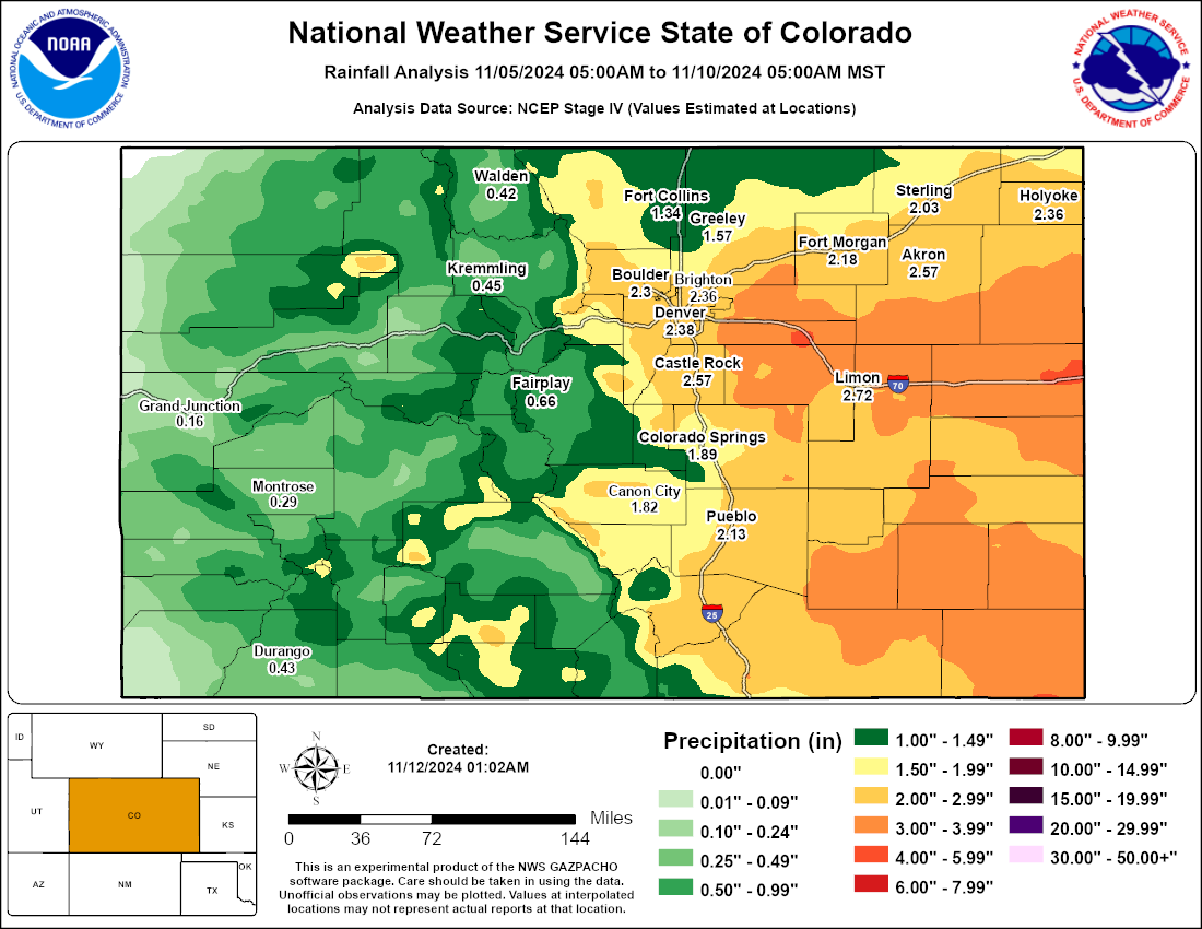
In addition, this was a very heavy, wet snowfall that contained a significant amount of liquid (equivalent) precipitation. Total liquid equivalent in some areas exceeded a whopping 3 inches.
Environment
This was a long duration storm with three distinct waves of heavier snowfall. The first wave developed on the evening of November 5th. A cold front passed in the late afternoon hours, with brief upslope but mainly northerly flow developing behind it. This flow pattern, in addition to an area of mid level forcing, led to heavier snow developing over the southern Front Range Foothills, southern Denver suburbs, Palmer Divide, and adjacent plains east and northeast through Limon toward Akron (see the first animated radar imagery in the Radar and Satellite tab). That first round of snow gradually decreased on Wednesday, November 6th, but before it did snow had already accumulated between 12 and 18 inches in the foothills west and southwest of Denver, and between 10 and 16 inches from the far southern suburbs of Denver and Palmer Divide eastward across the adjacent plains.
After a decrease in the snow late on the 6th, the second round of snow arrived in the early morning hours of November 7th. This snow was heavier, and a little wetter than the previous round as temperatures warmed slightly and more moisture was drawn into the system. During this time, south to southeast flow developed as the storm system dropped south into Arizona (Figure 1). That flow and proximity of the upper level storm system supported heavy snowfall over much of Lincoln and Elbert Counties, extending northward into southern Washington and eastern Arapahoe Counties. Here, additional snowfall amounts were impressive, with another 5 to 12 inches of snow falling through late afternoon. Lighter snow fell further north, as the low level flow turns downslope off the Palmer Divide. That said, the disturbance and deeper richer moisture plume moving out ahead of the main storm was still able to produce another 1 to 3 inches for the Denver metro area. Meanwhile, locations even farther north including Fort Collins, Greeley, and Sterling saw only very light precipitation. November 7th marked the second consecutive day of heavy snow east and southeast of Denver, forcing the closure of numerous highways, almost all rural roads, and even Interstate 70 east of Denver to near the Kansas state line. Heavy snow finally decreased late in the day, with just bouts of lighter snow overnight into the early morning hours of November 8. But, the storm wasn't over yet.
In fact, the most significant and widespread precipitation for this stormy period was yet to come as the storm tracked closer to the area. The storm system on November 8th moved northeast across New Mexico and then north/northeast along the Colorado/Kansas border in the overnight hours. Rich Gulf of America moisture was drawn into the storm, and upslope flow increased as a more easterly component of winds (Figure 2) developed across the plains and backed toward the Front Range. Snow spread northwest across the area during the morning of the 8th, with periods of heavy snow into the overnight and early morning hours of the 9th. Temperatures continued to warm slightly during this time, which meant some of the lower elevations including the Highway 34 Corridor from Fort Collins to Greeley and Fort Morgan, as well as the I-76 Corridor northeast of Fort Morgan, saw a mix of rain and snow and temperatures too warm to support significant snow accumulations. In fact, areas around Fort Collins only saw about an inch of slushy snow. Meanwhile, the periods of heavy snow accumulated to even greater depths south and east of Denver where another 8-20 inches fell. That brought storm totals to historical levels in those locations - well over 30 inches, with a few spots seeing totals over 40 inches! Why historical? Only the great storm of November, 1946 (Figure 3) produced even higher totals for those particular areas southeast of Denver. A couple reports from the 1946 storm included a total of 46 inches at the Karval, Colorado Cooperative Weather Observing station, and up to 50 inches farther south near Eads, Colorado.
Like the significant storm earlier this year on March 13-15, 2024, liquid equivalent precipitation was impressive with over 3 inches of liquid equivalent in some areas, or nearly 20% of normal annual precipitation. This storm, however, produced these significant amounts east and southeast of Denver (see Storm Reports section), rather than in/next to the foothills as in the March storm.
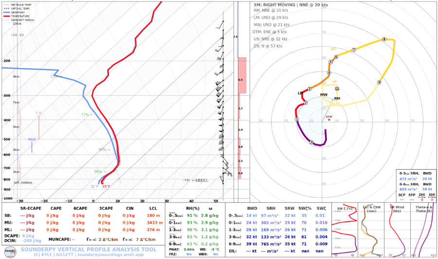
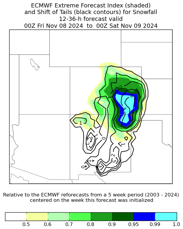
How did this storm produce so much snow? For starters, it was a long duration storm with snow falling off and on for nearly 90 hours from Denver Metro to points south and east. Also, the airmass was extremely moist with some of the highest water content available for a winter storm, without being too warm to rain with the exception of the far northern/northeast plains. Figure 4 shows a model forecast of the atmospheric profile over Limon during the early morning hours of November 7th, near the beginning of the second wave of heavier snow. There is deep southeasterly flow producing upslope on that side of the Palmer Divide, with only a shallow but cool northerly low level flow keeping the low level cold air in place. The lines of red (temperature) and blue (moisture) show a profile of deep moisture through the atmospheric column up to about 300 mb, or ~30,000 feet. From a forecaster perspective, the amount of moisture and snowfall when looking at model output was remarkable for some areas. A new tool that can give us confidence that an extreme precipitation event is unfolding can be found in Figure 5. That might look strange to the general population, but forecasters can better communicate the threat level when we see that models have never, or very rarely, forecast this magnitude of an event before. Finally, forecasters can then communicate that threat level with all through a variety of means, via social media, weather briefings to partners, and of course point specific forecasts. One means of doing that is shown in Figure 6, the Winter Storm Severity Index. In this case, the forecast calls for "Extreme" impacts southeast of Denver and over much of southeast Colorado, exactly where that historic snowfall occurred. Meanwhile, much less impacts were forecast farther north. It's a new and improved way that NWS meteorologists can communicate the potential and severity of winter storms, what kind of impacts the storm will bring for a specific location, and where to avoid travel or other activities.
 |
 |
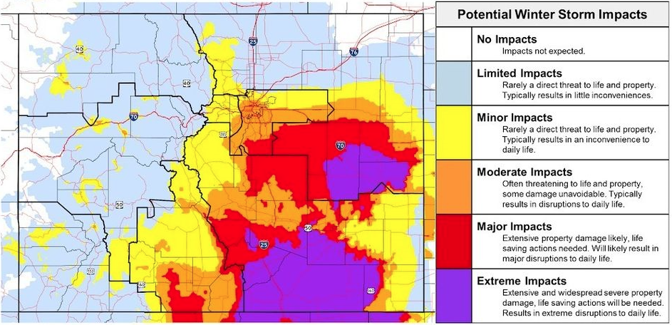 |
| Figure 4: Forecast model sounding for Limon, CO at 5 am, November 7, 2024. | Figure 5: Extreme Forecast Index and Shift of Tails for Snowfall. | Figure 6: Winter Storm Severity Index forecast for November 7 - 9. |
 |
Media use of NWS Web News Stories is encouraged! Please acknowledge the NWS as the source of any news information accessed from this site. |
 |