Severe thunderstorms formed across eastern Colorado the afternoon of August 13, 2019. Several grew in strength and became supercells and by 2 PM several supercells began to interact with one another in northwestern Kit Carson County. At around 3 PM, the strongest of the storms generated hail to about 5" in diameter that fell on a farm northwest of the town of Bethune. This ended up being the largest hailstone officially analyzed and recorded in the state of Colorado. Amazingly, just two days prior and about 60 miles northwest of the record breaking hail, another supercell dropped grapefruit size hail with reports up of 5" diameter, but no hailstones were officially measured nor saved for later analysis from that event.
The record breaking hailstorm occurred just outside NWS Boulder's area of responsibility, in western Kit Carson County, CO. NWS Goodland has a great write up of the hailstone, hail damage, and subsequent certification of the largest stone officially measured and validated in the state of Colorado, at 4.83" diameter. Please visit the NWS Goodland page for those details. https://www.weather.gov/gld/8132019CORecordHailstone
For a detailed and somewhat technical explanation of the radar characteristics, continue reading below.

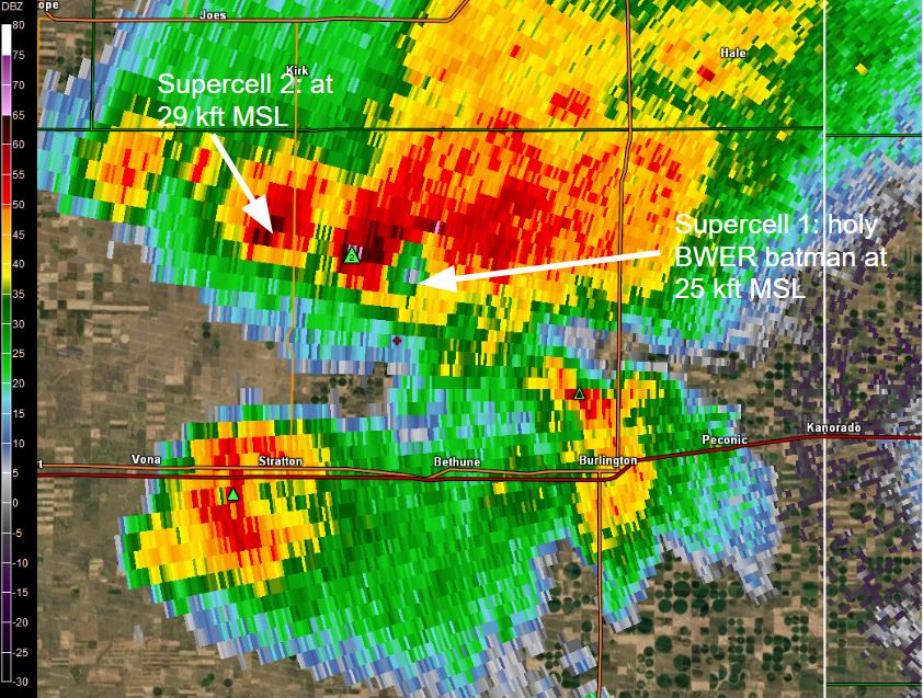
In the image above, from Goodland's Radar (KGLD), the red cross is the location of the record breaking hail, about 7 miles north-northeast of Bethune. This image is from 2:49 PM MDT on 8/13/19. Note there are two supercells north of the red cross, and both are intense, likely producing severe hail. The filled in green triangles with numbers are severe hail size estimation from a radar algorithm, in inches diameter. For referecne, "BWER" is a Bounded Weak Echo Region, which is an indication of an intense updraft. The feature appears as a reflectivity weakness in the mid levels where the updraft is so strong only a few precipitation particles (sometimes huge hail) exist in the core of the updraft. The next image shows the BWER from supercell #1.
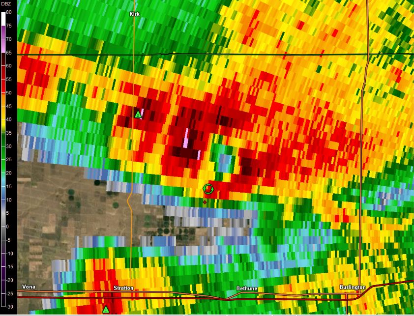
The above is KGLD radar reflectivity from 2:50 PM MDT at the 5 deg elevation angle, showing the giant BWER in supercell 1, and a robust core aloft in supercell #2. The two supercells merged in the next 10 minutes or so.
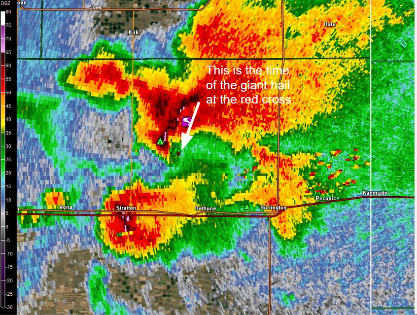
This is the next scan above is from KGLD radar reflectivity, at 5 deg elevation angle. A mesocyclone (rotation within the storm) is the green circle, just north of the red cross where the giant hail fell. This image is from 2:55 PM MDT, which is about 5 minutes from the record breaking hail reaching the ground. The storm has a giant BWER just northeast of the red cross, indicating the updraft is passing right over the red cross now.
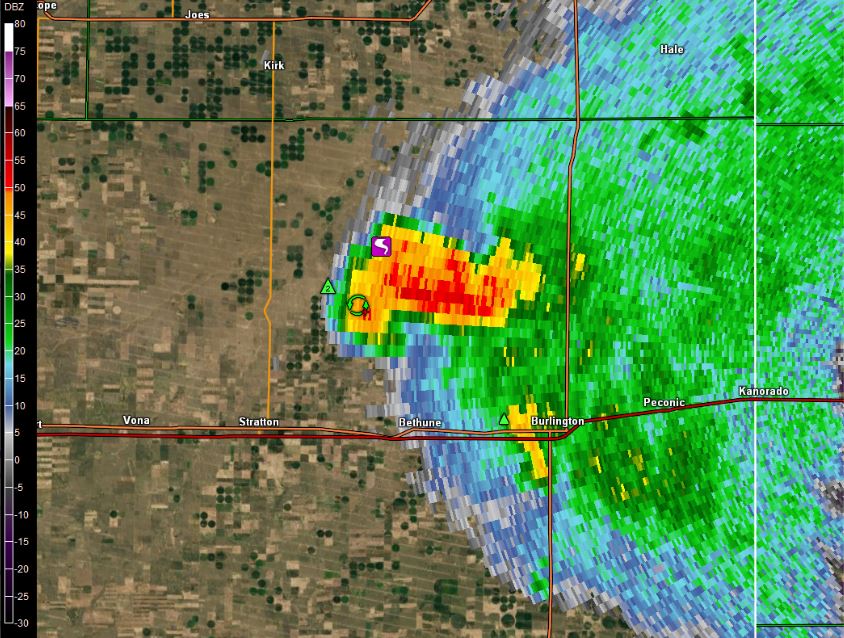
KGLD radar reflectivity at the lowest available elevation angle (0.5 deg) at 3:00 PM MDT. Note the red cross is located in the inflow notch, the location of the low-level updraft. This is a typical signature for giant hail in supercells. The largest hail falls very near the core of the updraft, and not typically associated with much rainfall or other sized hail. To the west of the red cross is the rear flank, normally associated with a drowndraft or descending air. In that region smaller hail and some rain would occur at the red cross site, after the giant hail had already fallen.
One final radar reflectivity image from KGLD radar at 3:02 PM MDT at 12.5 deg elevation angle. This is impressive. Directly overhead the red cross where giant hail had just reached the round, the storm top extends to over 55,000 feet above sea level (MSL)! There are radar reflectivity values at 54 dBZ at a height of 55,000 feet. The storm stop likely reached 60,000 feet MSL. This storm height is on par (though still a little less impressive) with some of the largest hail recorded in the U.S., in Vivian, SD (the U.S. record) and Aurora, NE (the previous U.S. record). The tornado icon is a local storm report of a tornado from this time.

