National Weather Service United States Department of Commerce

Severe Weather Across the Ohio Valley and into the Mid Atlantic; Prolonged Heat in the Southern Plains

Scattered damaging winds and a couple tornadoes are possible on Saturday from parts of Ohio into northern West Virginia/Maryland, central and western Pennsylvania, and western New York. The thunderstorm threat will move into the Northeast on Sunday. Prolonged heat will continue across the Southern Plains this weekend and into next week. Read More >

Overview

On May 20, 2020, six landspout tornadoes occurred in Weld County in about an hour's time between 630 and 730 PM MDT. The tornadoes tracked in a southeast to northwest direction over open country in an area from 5 miles east of Greeley to just east of Eaton. NWS Boulder meteorologists rated all six tornadoes as EF-0, with wind speeds of 85 mph or less. Three lasted less than 10 minutes, and the longest lived tornado was on the ground for 25 minutes and had a track length of 8 miles. Fortunately the combination of open terrain and their weak strength minimized damage. The tornadoes were weak enough that only a few reports of damage were received by the NWS Boulder office, and all damage was consistent with the EF-0 rating. Three farmsteads were impacted with minor damage, and there were no injuries or deaths.  

A landspout tornado is a narrow, rope-like funnel that forms while the thunderstorm cloud is still growing and there is no rotating updraft - the spinning motion originates near the ground, typically along a near-surface boundary between two different, converging airmasses. The tornadoes in Weld County that evening were roughly 6-8 miles west of the precipitation cores of the parent thunderstorms, and none the storms were supercells. Landspout tornadoes tend to be short lived and are usually weak. 

On May 20, 2020, there was a boundary separating moist air to the east, and dry air to the west, extending north-northwest to south-southeast across Weld County.  The boundary was rich in vertical vorticity, which is a measure of how quickly a column of air is rotating.  If a strong storm developed on top of the boundary, it ingests the vertical vorticity, stretching it in the vertical direction, generating a tornado.  This case was interesting in that the tornadoes moved northwest along the boundary, and were widely separated from the precipitation cores of the storms responsible for stretching and tilting the vorticity.  

This event was particularly challenging to document the location and start/end times of each of the tornadoes.  Five of the six tornadoes occurred in a 25 square mile area.  Three of the tracks were very close together, only separated by about 10 minutes.  Thus, the caveat here is we did the best we could, and could not have done it without several key eye witness photos/videos.  Could we have missed a short lived tornado?  Perhaps.  But we have accounted for every photo and video received so far.

Thank you to all of you who provided video and photos.  Your input is invaluable in real-time and after the event.

Image
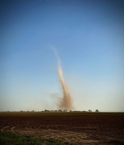
One of the landspout tornadoes in Weld County on May 20, 2020.  Note that they were far removed from the precipitation, at times 6-8 miles away.  Photo courtesy Paul Naney.
Image Image
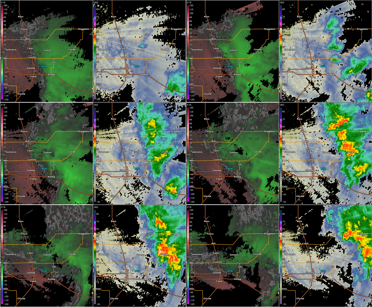
CSU's "CHIVO" radar showing Doppler Velocity on the left and reflecivity on the right.  This is an animatoion from 6:00 to 7:30 PM MDT.  All of the tornadoes were in essentially clear air returns in reflectivity.  Of note is a meso-vortex, which is seen rotating and moving southward along and then east of US 85 in the reflectivity image.  It is not a tornado but may have been responsible for generating tornadoes along the moisture boundary just to the east.  You can see it via a swirl in the light blues and dark blues.  This is the feature that intersects the near-surface boundary and generates "spin" just off the surface.  Strong convection aloft stretches the spin (vorticity) into tornadoes form the ground up. Photo of the convection at 8:15 as seen from Longmont.  Photo courtesy David Donahue.

Tornadoes

Tornado #1 - 2 miles E of Greeley Airport
WELD COUNTY

Date May 20, 2020
Time (Local) 1838 - 1842 MDT
EF Rating EF-0
Est. Peak Winds 65 mph
Path Length 0.9 mile
Max Width 50 yds
Injuries/Deaths 0/0

Summary:

This short lived landspout tornado was caught on video by a storm spotter from a location at Weld County Roads (WCR) 74/43 and it was quite a ways away from the spotter in the video. The location and path were  approximated based on video and a dust/dirt detection and weak rotation from CSU's CHIVO radar at the time of the video.  No other known video or photos exist of the tornado and no damage reported.  It may be the same circulation as one of the tornadoes south of Weld County 66 but it is possible the dust dissipated for a bit before picking back up on the farm where the farmer in a tractor videoed it in front of her (tornado #3). CHIVO radar tracks the circulation over the farm just south of Weld Co 66 at 6:44 PM.  Video from the storm chaser at 74/43 showed it either dissipating or impossible to see from his vantage point right around 6:43 PM.  EF rating based on other tornadoes that day.

Track Map

Track Map EF-Scale

Downloadable KMZ File

Radar/Photo      
Tornado #1:  Photo courtesy Adam Schwartz, taken as a frame from his video of the tornado.      

Tornado #2 - 2 Miles East of Eaton
WELD COUNTY

Date 5/20/20
Time (Local) 1841 - 1845 MDT
EF Rating EF-0
Est. Peak Winds 75 mph
Path Length 1.4 miles
Max Width 50 yds
Injuries/Deaths 0/0

Summary:

This tornado was filmed by a storm chaser who was at the intersection of Weld Co 74/43, and it was very close to him.  It hit a farm just west of Weld Co 74/41 and did EF-0 damage consisting of blown in barn doors and a fiberglass canoe lofted into a tree.  Rated with a DOD of 2/3.


Track Map

May 20, 2020 Tornado Track Map EF-Scale

Downloadable KMZ File

Radar/Photo Radar/Photo    
Tornado #2:  Photo courtesy Adam Schwartz, taken as a frame from his video of the tornado EF-0 Damage.  Photo courtesy Adam Schwartz.    

Tornado #3 - 1 mile NE of Greeley Airport to 2 miles NE of Lucerne
WELD COUNTY

Date 5/20/20
Time (Local) 1845 - 1856 MDT
EF Rating EF-0
Est. Peak Winds 75 mph
Path Length 4 miles
Max Width 50 yds
Injuries/Deaths 0/0

Summary:

This tornado was filmed by a farmer in her tractor, most likely the very start of the tornado.  The start time and location is precise given the ground circulation formed less than 100 yds in front of a farmer in her tractor.  At the end of the video she didn't see any more dust but CHIVO radar indicates a tornado continuing to the NNW of her, in the direction and speed of motion such that it is likely the same circulation despite a lack of dust right at the surface.  A tornado was photographed a matter of minutes later by a storm chaser on CO-392 at the right location/time based on average movement of the tornadoes that day.   It struck an irrigation pivot and twisted it, consistent with EF-0 damage.  This tornado was also witnessed by the farmer's husband on another part of their farm.  The tornado moved northwest along the surface boundary and was videoed at 6:52 PM as being just north of CO-392.  The same chaser captured simultaneous tornadoes at 6:52:  this one and tornado #4 which was 2 miles south of CO-392 at the time.  Yet another photograph taken from east of Loveland on top of a hill shows two tornadoes 15 miles away to the east-northeast, separated by 2-4 miles, at exactly 6:54 PM.  That was this tornado and tornado #4.  CHIVO radar has it dissipating around 6:56 PM around the intersection of WCR 43/70.  Dissipation time and location are approximate based on radar.

Track Map

Track Map EF-Scale

Downloadable KMZ File

Radar/Photo Radar/Photo    
Tornado #3 from CO-392 looking northeast.  Photo courtesy Paul Naney. EF-0 damage to an irrigation sprinkler near the start of this tornado's path.    

Tornado #4 - From 1 mile NE of Greeley Airport to 3 miles NE of Lucerne
WELD COUNTY

Date 5/20/20
Time (Local) 1846 - 1901 MDT
EF Rating EF-0
Est. Peak Winds 83 mph
Path Length 4.8 miles
Max Width 50 yds
Injuries/Deaths 0/0

Summary:

This tornado was witnessed, photographed, and/or videoed by several people.  The start time/location is estimated by CHIVO radar as no eye witnesses saw it until 6:48 or 6:49 PM.  However, the radar signature shows dust/dirt and a decent circulation that is continuous throughout the the start/end times.  This tornado was filmed by a farmer in her tractor from 6:50-6:53, and was at least a mile to her northeast.  It was ongoing when she started filming.  The tornado was also photographed and filmed from 6:52 - 6:59 PM, roughly, by a chaser on CO-392.  At nearly the same time, a resident on WCR66 and east of WCR 47 videoed this tornado just to the NE and then N of her farm.  The chaser on CO-392 captured it crossing CO-392 and hitting a barn just north of CO-392, at 6:57 PM.  CHIVO radar shows a significant circulation and dust/dirt throughout the reported time window of this tornado, continuing north of CO-392. This tornado was also photographed from 15 miles east of Loveland at 6:54 PM, showing two tornadoes on the ground at the same time, this one and tornado #3 to the northwest.  Damage to the farm north of CO-392 was minor and consisted seriously damaging an aluminum shed, consistent with  high end EF-0 with winds 83 mph, and a Degree of Damage of 3.  The video shows the shed getting hit and debris scattered to the northwest.  The tornado dissipated somewhere around WCR70/45 based on radar.  An eyewitness on WCR45 north of WCR70 mentioned seeing a tornado prior to his filming a tornado at 7:14 PM (which was tornado #5).  We presume tornado #4 is the tornado he witnessed.   CHIVO has it dissipating around 7:01 PM.

Track Map

Track Map EF-Scale

Downloadable KMZ File

Radar/Photo Radar/Photo Radar/Photo Radar/Photo
Tornado #4 just north of CO-392.  It is hitting the shed at this time.  Photo courtesy a screen shot from Paul Naney's video.  EF-0 damage to an aluminum shed. Tornado #4 south of CO-392 at 6:52 PM.  Photo courtesy Paul Naney. Tornado #4 at around 6:50 PM 2.5 miles south of CO-392, and east of WCR49

Tornado #5 - From 3 Miles East of Greeley Airport to 1 Mile SE of Eaton
WELD COUNTY

Date 5/20/20
Time (Local) 1856 - 1921 MDT
EF Rating EF-0
Est. Peak Winds 83 mph
Path Length 8 miles
Max Width 50 yds
Injuries/Deaths 0/0

Summary:

This tornado was filmed or photographed numerous times along it's path, just like tornado #4 which was also longer track.  Tornado #5 was the longest track tornado for this event and we received photos, video, or eye witness accounts for nearly it's entire path.  In terms of it's depiction on CHIVO radar, this also had the best radar signatures for the event, both in regards to rotation on velocity products, and dust/dirt on reflectivity products.  The start of the tornado was estimated based on CHIVO radar with an easily trackable signature beginning 6:56 PM just north of WCR 60 1/2.  The tornado may have occurred earlier and further south based on CHIVO radar but we are using a conservative estimate for start time/location.  The first known person to witness this tornado was a spotter on WCR 47, just south of WCR66, at 7:04 PM.  He filmed the tornado not far to his east.   The same spotter photographed/videoed it through 7:09 PM when it was off to his north.  CHIVO radar had this tornado crossing CO-392 at around 7:07 PM.  A different chaser driving south on WCR 43 films the tornado starting at 7:08 PM, and films the tornado continuously until it dissipates at 7:21 PM.  A Weld County emergency management representative films this tornado from WCR 41 south of WCR 74 from 7:14 - 7:17 PM off to the south-southeast.  Two residents film this tornado between 7:14 - 7:17 from different angles, one north of WCR 70 on WCR45, and west of WCR 45 on WCR70.  Finally, a storm chaser captures a photo of this tornado to his southwest, from a hill on WCR 76/47.  The end time and location is precise for this tornado because it was filmed and the location was known.  This tornado went over several farms and managed to damage a older barn near the intersection of WCR72/43.  Damage consisted of a wall blown over from an outbuilding, consistent with EF-0 damage and a Degree of Damage of 3.

Track Map

Track Map EF-Scale

Downloadable KMZ File

Radar/Photo Radar/Photo Radar/Photo Radar/Photo
CSU's CHIVO radar at 7:04 PM.  Reflectivity is on the right, Base Velocity is on the left.  The location of the circulation at the radar beam height is inside a yellow circle.  The beam height is roughly 1,200 ft Above Ground Level (AGL).  A spotter took a photo from just south of WCR66 on WCR47 (photo is next one to the rigth) Tornado #4 at 7:05 PM.  Photo courtesy of Andrew Halpern. Tornado #4 at 7:16 PM.  Photo Courtesy Wendi Flynn Damage to a barn outbuilding south of WCR72 and wst of WCR43.

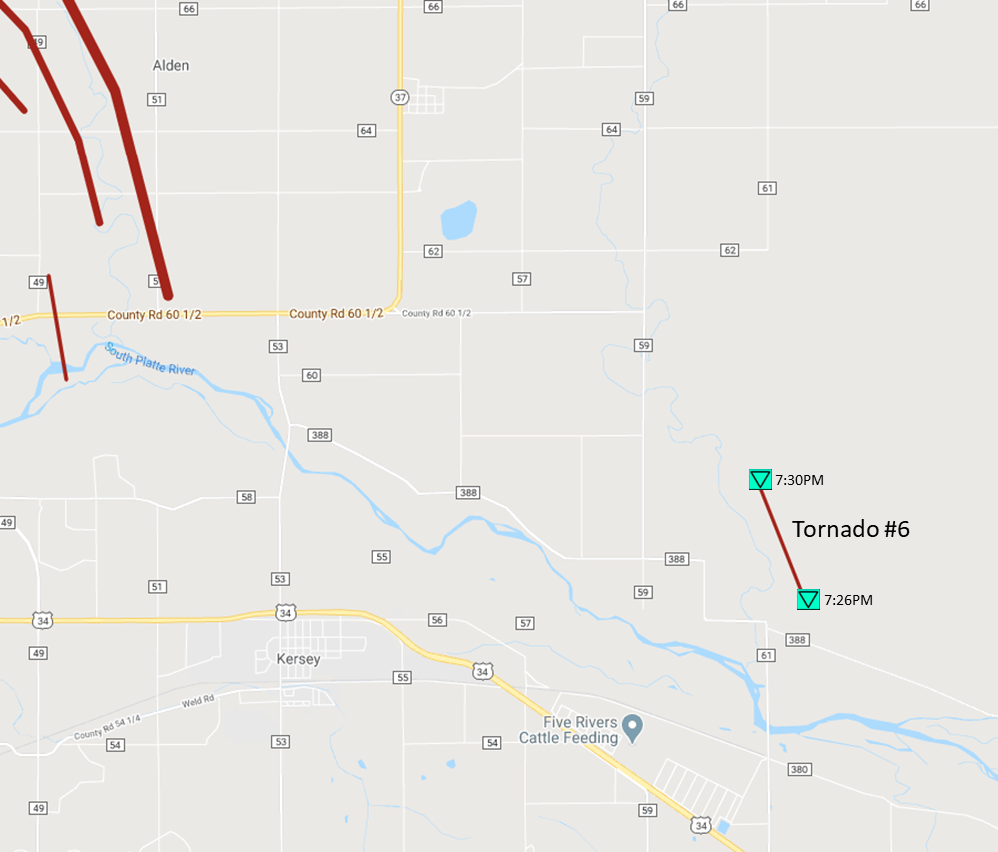
Tornado #6 - 5 Miles E of Kersey
COUNTY NAME

Date 5/20/20
Time (Local) 1926 - 1930 MDT
EF Rating EF-Unknown
Est. Peak Winds N/A
Path Length 1.0 miles
Max Width 50 yds
Injuries/Deaths 0/0

Summary:

This brief tornado was photographed by storm chasers and CSU's CHIVO radar had some weak rotation in this area.  Location and path are both approximate and based on radar from a range of about 45 nm.  The tornado did not damage anything but it's safe to assume EF-0 based on all other tornadoes this day.

Track Map

Track Map EF-Scale

Downloadable KMZ File


The Enhanced Fujita (EF) Scale classifies tornadoes into the following categories:

EF0
Weak

65-85 mph
EF1
Moderate
86-110 mph
EF2
Significant
111-135 mph
EF3
Severe
136-165 mph
EF4
Extreme
166-200 mph
EF5
Catastrophic
200+ mph
ef-scale


nws logo Media use of NWS Web News Stories is encouraged!
Please acknowledge the NWS as the source of any news information accessed from this site.
nws logo