Alabama Tornado Database |
|||||||||||
| 1971 Tornado Occurrences (22) | |||||||||||
| Tornado # of Year | Year | Month | Day | Time (CST) | County | Damage Scale | Path Length (Miles) | Maximum Path Width (Yards) | Fatalities | Injuries | Location |
| 22 | 1971 | 12 | 20 | 0330 | Monroe | F3 | 1.0 | 100 | 0 | 1 | Uriah One building was destroyed at the Blackshear School and 3 other buildings were damaged. One church and at least 8 other homes were damaged. Start: 31.30/-87.52 End: 31.30/-87.52 |
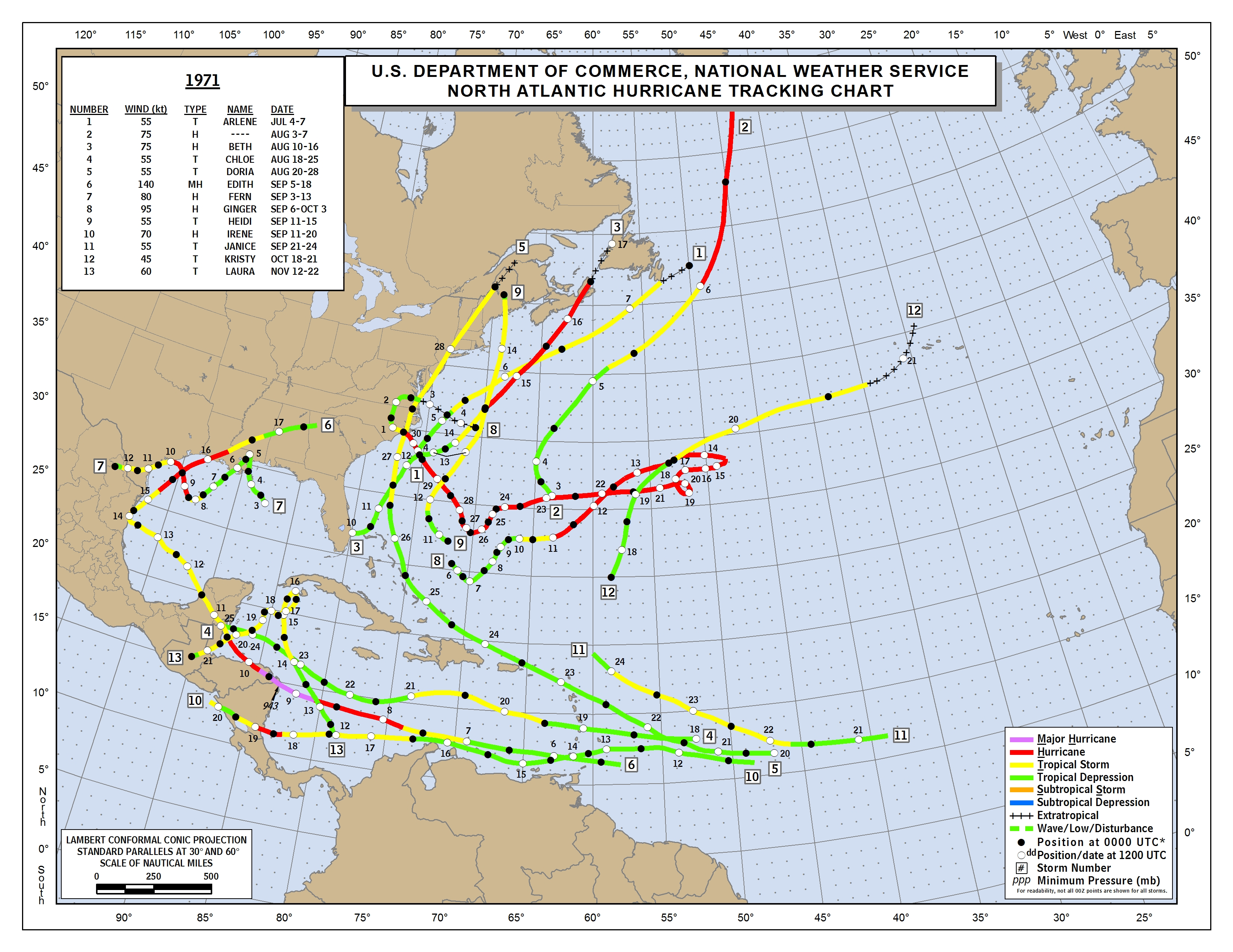
| 21 | 1971 | 9 | 17 | 0035 | Coffee 1971 Hurricane Map Hurricane Edith Information Hurricane Edith Information |
F3 | 0.3 | 100 | 0 | 0 | Danley One home was destroyed during this brief tornado touchdown. Start: 31.42/-86.17 End: 31.42/-86.17 |
| 20 | 1971 | 9 | 16 | 1622 | Baldwin 1971 Hurricane Map Hurricane Edith Information Hurricane Edith Information |
F2 | 1.0 | 150 | 0 | 0 | 4 E Fairhope At least 2 homes were torn apart. Several additional homes were damaged. Start: 30.53/-87.85 End: 30.53/-87.85 |
| 19 | 1971 | 9 | 16 | 1525 | Baldwin 1971 Hurricane Map Hurricane Edith Information Hurricane Edith Information |
F1 | 8.7 | 100 | 0 | 0 | 2 NW Perdido-4.2 NW Atmore At least 2 mobile homes were demolished. At least 10 homes suffered damage. A few barns were destroyed. Start: 31.03/-87.65 End: 31.08/-87.52 |
| 18 | 1971 | 9 | 16 | 1500 | Washington 1971 Hurricane Map Hurricane Edith Information Hurricane Edith Information |
F1 | 2.0 | 200 | 0 | 0 | Tibbie One house and several large chicken houses were severely damaged. Several small buildings were destroyed. Numerous trees were blown down. Start: 31.35/-88.26 End: 31.37/-88.23 |
| 17 | 1971 | 9 | 16 | 1330 | Washington 1971 Hurricane Map Hurricane Edith Information Hurricane Edith Information |
F2 | 5.7 | 200 | 0 | 0 | 1 N Tibbie-6.7 SE Chatom Several houses damaged and shifted off foundations. Heavy damage to timber as the tornado moved through forests. Start: 31.37/-88.25 End: 31.40/-88.17 |
| 16 | 1971 | 6 | 15 | 1315 | Etowah | F1 | 0.5 | 10 | 0 | 0 | Youngs Chapel One home and a store were damaged. Many trees were uprooted. Start: 34.05/-86.05 End: 34.05/-86.05 |
| 15 | 1971 | 4 | 23 | 1140 | Monroe-Butler | F4 | 25.4 | 300 | 0 | 0 | Old Texas-Greenville Near total destruction occurred along the first 10 miles of the tornado path. Start: 31.50/-87.30 End: 31.77/-87.00 |
| 14 | 1971 | 4 | 23 | 1115 | Pike | F1 | 1.0 | 200 | 0 | 0 | 2 W Troy Airport-1 W Troy Aiport One small barn was destroyed and many trees were downed. Start: 31.87/-86.05 End: 31.87/-86.05 |
| 13 | 1971 | 3 | 6 | 1630 | Jefferson | F2 | 4.9 | 300 | 0 | 2 | 1 S Clay-Goodner Mountain 3 homes were damaged and occupants in one home were injured. Many trees were downed. Start: 33.68/-86.60 End: 33.72/-86.53 |
| 12 | 1971 | 3 | 3 | 0400 | Pike | F3 | 2.0 | 10 | 0 | 0 | Brundidge 2 homes were demolished, 3 trucks were overturned, a mobile home was overturned, and several other structures were damaged. Many trees were downed along the path. Start: 31.72/-85.84 End: 31.74/-85.81 |
| 11 | 1971 | 3 | 2 | 2120 | Clarke | F3 | 4.9 | 100 | 0 | 0 | Tallahatta Springs-Thomasville A school gym was severely damaged in Thomasville. A section of the school was unroofed. One service station was destroyed and at least 2 homes were damaged. Start: 31.90/-87.82 End: 31.92/-87.73 |
| 10 | 1971 | 3 | 2 | 1000 | Pike-Barbour | F3 | 23.8 | 10 | 0 | 0 | W Springhill-N Brundidge-Louisville One house and barn were damaged near Springhill. 3 homes were destroyed and a country club and warehouse were damaged in North Brundidge. Several farm buildings and homes were damaged near Louisville. Start: 31.68/-85.97 End: 31.73/-85.57 |
| 9 | 1971 | 3 | 1 | 1615 | Houston | F2 | 0.1 | 10 | 0 | 0 | Dothan A furniture store and a few other buildings were damaged along Highway 431. 2 automobiles were overturned. Start: 31.22/-85.40 End: 31.22/-85.40 |
| 8 | 1971 | 2 | 26 | 1405 | Chambers-Lee | F1 |
7.3 |
50 | 0 | 0 | 5 SW Waverly-Waverly One mobile home was demolished, one home was unroofed, two homes suffered damaged, and some barns were destroyed. Many trees were blown down. Start: 32.65/-85.57 End: 32.68/-85.45 |
| 7 | 1971 | 2 | 26 | 1400 | Randolph | F0 | 0.1 | 10 | 0 | 0 | Roanoke 2 small buildings were destroyed and several trees were snapped off. Start: 33.13/-85.38 End: 33.13/-85.38 |
| 6 | 1971 | 2 | 26 | 1230 | Jefferson | F1 | 2.0 | 50 | 0 | 3 | East Lake-Roebuck Minor structural damage was reported and many trees were uprooted or snapped off. Start: 33.57/-86.72 End: 33.59/-86.70 |
| 5 | 1971 | 2 | 26 | 1100 | Greene | F3 | 4.3 | 50 | 0 | 0 | 3 SW Eutaw-1 E Eutaw 8 homes were destroyed, 19 homes were damaged, 2 mobile homes were demolished, and a few buildings were heavily damaged. Start: 32.82/-87.93 End: 32.83/-87.87 |
| 4 | 1971 | 2 | 12 | 0855 | Mobile | F1 | 1.0 | 33 | 0 | 0 | Wilmer-Kushla One barn and one slaughterhouse were damaged. Numerous trees were uprooted. Start: 30.82/-88.37 End: 30.82/-88.37 |
| 3 | 1971 | 2 | 4 | 1945 | Marion-Franklin | F3 | 34.1 | 700 | 1 | 13 | 7 S Hamilton-Sugar Bend-Bear Creek-Dime Extensive dmaage occurred along the entire path. 50 homes were damaged or destroyed. Several barns and outbuildings were demolished. Several mobile homes were destroyed. Start: 34.03/-87.95 End: 34.38/-87.53 |
| 2 | 1971 | 1 | 25 | 1615 | Cleburne | F1 | 1.0 | 10 | 0 | 0 | Heflin A school bus garage was damaged, a frame home was unroofed, and other minor damage occurred along the path. Start: 33.63/-85.60 End: 33.63/-85.60 |
| 1 | 1971 | 1 | 25 | 1500 | Blount | F0 | 2.0 | 10 | 0 | 0 | Cleveland-Nectar One home was unroofed, 2 homes were damaged, and several farm buildings were demolished. Numerous trees were uprooted. Start: 33.97/-86.63 End: 33.99/-86.60 |

