Alabama Tornado Database
|
|||||||||||
| 1957 Tornado Occurrences (44) | |||||||||||
| Tornado # of Year | Year | Month | Day | Time (CST) | County | Damage Scale | Path Length (Miles) | Maximum Path Width (Yards) | Fatalities | Injuries | Location |
| 44 | 1957 | 12 | 20 | 0300 | Conecuh Storm Information |
F1 | 4 | 33 | 0 | 0 | 4 E Castleberry-8 E Castleberry 2 homes and a barn were destroyed. Start: 31.30/-86.95 End: 31.30/-86.88 |
| 43 | 1957 | 12 | 20 | 0253 | Chilton Storm Information |
F1 | 0.1 | 10 | 0 | 0 | Clanton The Dan River Mills had part of its roof ripped off. At least 20 homes suffered varying degrees of roof damage. Start: 32.80/-86.65 End: 32.80/-86.65 |
| 42 | 1957 | 12 | 19 | 2315 | Colbert Storm Information |
F2 | 0.1 | 10 | 0 | 7 | Littleville City Hall and 7 businesses were damaged.3 homes were destroyed and many others damaged. Start: 34.60/-87.67 End: 34.60/-87.67 |
| 41 | 1957 | 12 | 19 | 2230 | Fayette Storm Information |
F1 | 0.1 | 10 | 0 | 0 | 4 S Winfield 1 home and outbuildings destroyed. Start: 33.87/-87.80 End: 33.87/-87.80 |
| 40 | 1957 | 11 | 18 | 1730 | Blount-Marshall Storm Information |
F4 | 26.1 | 100 | 3 | 12 | Rosa-Snead-Horton 40 homes were destroyed in Blount County and all the fatalities occurred there. Start: 33.98/-86.52 End: 34.27/-86.22 |
| 39 | 1957 | 11 | 18 | 1730 | Clay Storm Information |
F2 | 0.1 | 10 | 0 | 0 | Ashland 3 buildings badly damaged. Several other roofs and porches damaged. Start: 33.27/-85.85 End: 33.27/-85.85 |
| 38 | 1957 | 11 | 18 | 1715 | Cleburne Storm Information |
F1 | 0.1 | 10 | 0 | 0 | Near Macedonia Several broiler houses and 1 trailer destroyed. Scattered roof and porch damage. Start: 33.70/-85.60 End: 33.70/-85.60 |
| 37 | 1957 | 11 | 18 | 1700 | Morgan Storm Information |
F1 | 0.1 | 10 | 0 | 0 | Hulaco Tornado destroyed one home, reomved back porch from another home, blew washhouse away, and unroofed a barn in Hulaco. Start: 34.32/-86.60 End: 34.32/-86.60 |
| 36 | 1957 | 11 | 18 | 1700 | Morgan-Lawrence Storm Information |
F1 | 0.1 | 10 | 0 | 0 | Moulton One home was destroyed and a few other structures were damaged. Start: 34.50/-87.20 End: 34.50/-87.20 |
| 35 | 1957 | 11 | 18 | 1635 | Tallapoosa Storm Information |
F1 | 0.1 | 10 | 0 | 0 | Near Alexander City 2 houses, 1 trailer and other buildings destroyed. Start: 32.95/-85.97 End: 32.95/-85.97 |
| 34 | 1957 | 11 | 18 | 1615 | DeKalb Storm Information |
F1 | 0.1 | 10 | 0 | 0 | Dawson 2 homes were torn apart. Start: 34.33/-85.83 End: 34.33/-85.83 |
| 33 | 1957 | 11 | 18 | 1530 | Jefferson Storm Survey Storm Information |
F2 | 8.2 | 100 | 1 | 35 | Ensley-Tarrant City At least 500 homes were damaged. Start: 33.60/-86.80 End: 33.63/-86.67 |
| 32 | 1957 | 11 | 18 | 1445 | Tuscaloosa Storm Information |
F1 | 3.3 | 10 | 0 | 1 | 12 N Tuscaloosa At least 7 homes suffered major damage and several automobiles were destroyed. Start: 33.40/-87.53 End: 33.42/-87.48 |
| 31 | 1957 | 11 | 18 | 1445 | Dallas Storm Information |
F1 | 37.3 | 10 | 0 | 0 | Safford-Near Orrville-Marion Junction-Summerfield-Plantersville Tornado made a skipping path with brief touchdowns along path. Hail the size of hens' eggs. Start: 32.28/-87.37 End: 32.67/-86.92 |
| 30 | 1957 | 11 | 18 | 1430 | Greene-Hale Storm Information |
F1 | 28.0 | 10 | 0 | 5 | Forkland-Sawyerville-Near Akron-Havana A few barns and homes were damaged. Start: 32.65/-87.90 End: 32.95/-87.58 |
| 29 | 1957 | 11 | 18 | 1330 | Franklin Storm Information |
F2 | 7.4 | 10 | 0 | 0 | Belgreen-2 NW Russellville One home was heavily damaged and another home was pushed off its foundation. Start: 34.48/-87.87 End: 34.53/-87.75 |
| 28 | 1957 | 11 | 17 | 1610 | Cullman Storm Information |
F1 | 9.2 | 10 | 0 | 3 | Trimble-Crane Hill Tornado touched down in a rural area damaging mainly cotton crops. Start: 34.10/-87.05 End: 34.15/-86.90 |
| 27 | 1957 | 11 | 17 | 1512 | Walker Storm Information Storm Information |
F4 | 7.2 | 200 | 4 | 15 | 6 NW Jasper-1 N Manchester A new ranch home was demolished and 3 people were killed. Another death occurred in a destroyed home. Start: 33.90/-87.18 End: 33.93/-87.30 |
| 26 | 1957 | 11 | 17 | 1310 | Lamar Storm Information |
F1 | 6.15 | 10 | 0 | 0 | Sulligent Tornado produced non-continuous damage path. No significant damage was noted. Start: 33.90/-88.13 End: 33.90/-88.13 |
| 25 | 1957 | 11 | 8 | 0430 | Shelby | F1 | 4.1 | 50 | 0 | 0 | 2 NE Columbiana-2 W Wilsonville Tornado produced non-continuous damage path. No significant damage was noted. Start: 33.90/-86.57 End: 33.23/-86.52 |
| 24 | 1957 | 11 | 8 | 0225 | Pickens | F1 | 7.8 | 10 | 0 | 5 | 1.2 E Aliceville - 8.7 E Aliceville At least 15 homes were damaged. Start: 33.13/-88.13 End: 33.18/-88.00 |
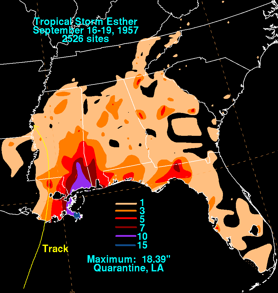
| 23 | 1957 | 9 | 18 | 1445 | Dallas-Autauga Hurricane Report 1957 Atlantic Hurricane Season Map Tropical Storm Esther |
F0 | 11.9 | 100 | 0 | 0 | E Selma - Jones Tornado touched down along the river where 3 tenant homes were destroyed and 3 were damaged. Crops of cotton were damaged. Associated with Tropical Storm Esther. Start: 32.40/-86.87 End: 32.52/-86.72 |
| 22 | 1957 | 8 | 15 | 1730 | Lee Hurricane Report 1957 Atlantic Hurricane Season Map Tropical Storm Bertha Report |
F1 | 0.1 | 133 | 0 | 0 | Smiths 2 homes had considerable damage and 2 barns were destroyed. Start: 32.53/-85.08 End: 32.53/-85.08 |
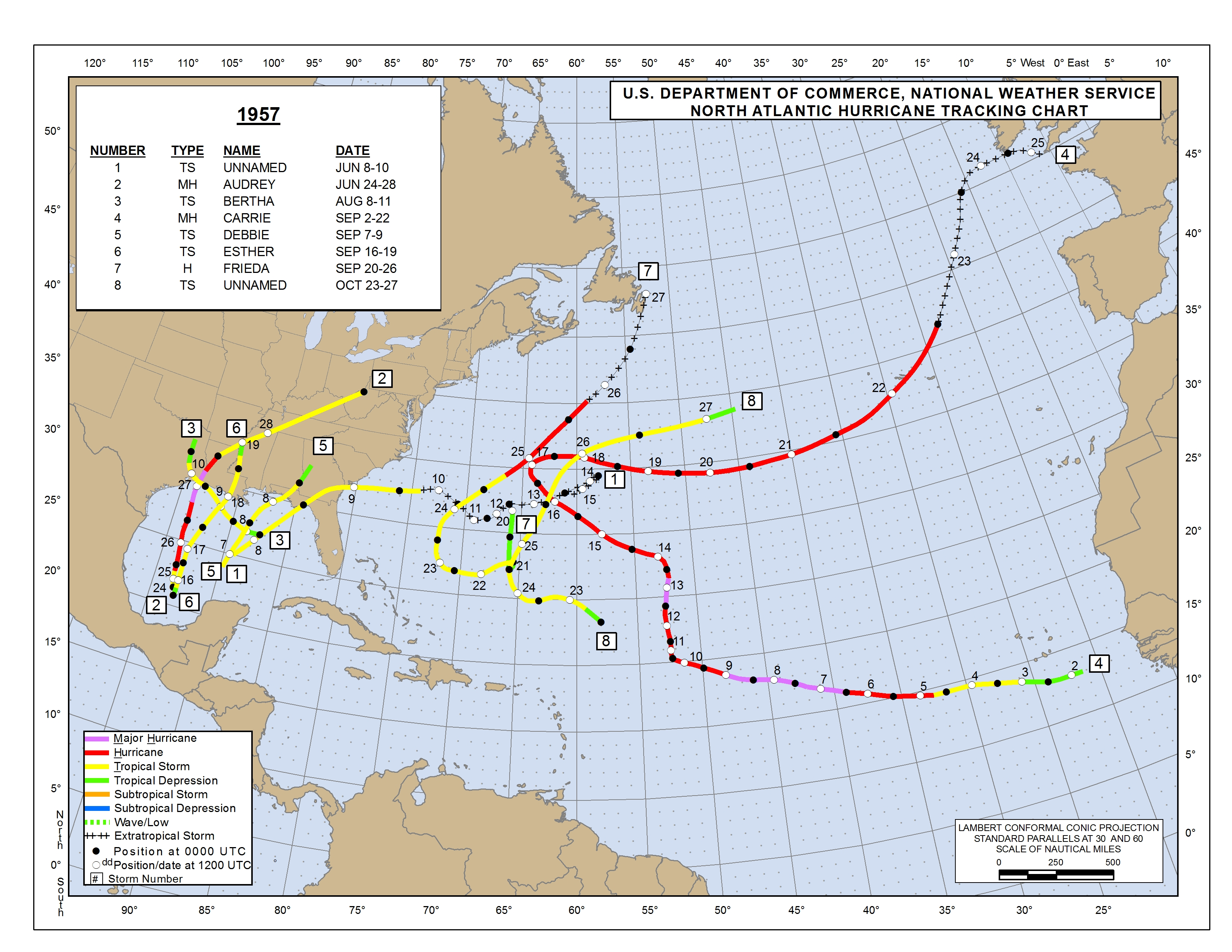
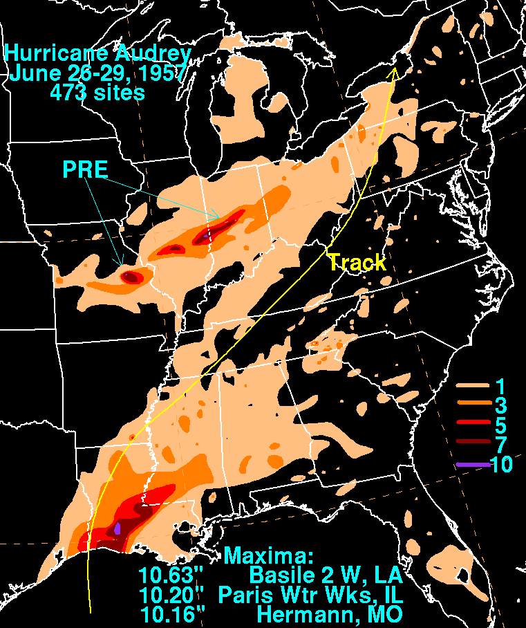
| 21 | 1957 | 6 | 28 | 1745 | Barbour Information Audrey Rainfall 1957 Atlantic Hurricane Season Map Hurricane Audrey Report Storm Information |
F2 | 16.5 | 100 | 0 | 1 | 8 NE Brundidge-Batesville 2 homes destroyed, 4 barns destroyed, several other smaller buildings destroyed, and considerable timber damage along the path. All the tornadoes on June 28 were associated with tropical system Audrey. Start: 31.80/-85.67 End: 31.97/-85.47 |
| 20 | 1957 | 6 | 28 | 1150 | Crenshaw Information Audrey Rainfall 1957 Atlantic Hurricane Season Map Hurricane Audrey Report Storm Information |
F0 | 0.1 | 10 | 0 | 0 | Near Luverne State Trooper witnessed a brief tornado touchdown in a rural area outside Luverne. A few trees were blown down. Start: 31.70/-86.30 End: 31.70/-86.30 |
| 19 | 1957 | 6 | 28 | 1100 | Conecuh-Covington-Butler Information Audrey Rainfall 1957 Atlantic Hurricane Season Map Hurricane Audrey Report Storm Information |
F2 | 11.5 | 200 | 0 | 2 | 5.5 WNW Red Level - 5.6 NE McKenzie Several homes were unroofed and a church was heavily damaged. Start: 31.43/-86.70 End: 31.58/-86.63 |
| 18 | 1957 | 6 | 28 | 1030 | Conecuh Information Audrey Rainfall 1957 Atlantic Hurricane Season Map Hurricane Audrey Report Storm Information |
F1 | 0.1 | 10 | 0 | 0 | Near Middleton Field This short path tornado destroyed one barn and some timber. Bands from Hurricane Audrey. Start: 31.20/-85.40 End: 31.20/-85.40 |
| 17 | 1957 | 6 | 28 | 1030 | Montgomery-Bullock Information Audrey Rainfall 1957 Atlantic Hurricane Season Map Hurricane Audrey Report Storm Information |
F0 | 8.9 | 167 | 0 | 0 | 8.9 NE SPrague - 1.7 NW Union Springs One house and one barn destroyed. Several trees downed along the path. Bands from Hurricane Audrey. Start: 32.17/-86.13 End: 32.18/-85.98 |
| 16 | 1957 | 6 | 28 | 1025 | Conecuh-Butler Information Audrey Rainfall 1957 Atlantic Hurricane Season Map Hurricane Audrey Report Storm Information |
F2 | 14.5 | 133 | 0 | 0 | 4 WNW Evergreen - Jones Chapel One home and one store were destroyed. Bands from Hurricane Audrey. Start: 31.42/-87.05 End: 31.48/-86.82 |
| 15 | 1957 | 6 | 28 | 1015 | Butler Information Audrey Rainfall 1957 Atlantic Hurricane Season Map Hurricane Audrey Report Storm Information |
F2 | 12.3 | 133 | 0 | 0 | 6 SW Greenville-6 ENE Greenville Major damage was reported at Kolb City and at a junior college just southeast of town. A farm was damaged east of Greenville. Bands from Hurricane Audrey. Start: 31.77/-86.72 End: 31.85/-86.53 |
| 14 | 1957 | 6 | 28 | 1000 | Lowndes-Montgomery Information Audrey Rainfall 1957 Atlantic Hurricane Season Map Hurricane Audrey Report Storm Information |
F1 | 22.3 | 50 | 0 | 8 | S Fort Deposit-Sprague Several trees blown down along the path. All injuries occurred in the Davenport community as homes and a cafe were destroyed along US 31. Bands from Hurricane Audrey. Start: 31.97/-86.58 End: 32.13/-86.27 |
| 13 | 1957 | 6 | 28 | 0955 | Monroe Information Audrey Rainfall 1957 Atlantic Hurricane Season Map Hurricane Audrey Report Storm Information |
F2 | 12.1 | 100 | 0 | 4 | 1 S Frisco City-Bermuda A store and some homes were destroyed near the Excel community. Bands from Hurricane Audrey. Start: 31.42/-87.40 End: 31.53/-87.25 |
| 12 | 1957 | 6 | 28 | 0945 | Conecuh-Butler Information Audrey Rainfall 1957 Atlantic Hurricane Season Map Hurricane Audrey Report Storm Information |
F2 | 23.2 | 440 | 0 | 0 | 10 W Evergreen-3 S Butler Springs At least 7 homes were destroyed. Several additional smaller homes were unroofed or overturned. Bands from Hurricane Audrey. Start: 31.40/-86.90 End: 31.63/-86.62 |
| 11 | 1957 | 6 | 28 | 0935 | Lowndes-Montgomery Information Audrey Rainfall 1957 Atlantic Hurricane Season Map Hurricane Audrey Report Storm Information |
F2 | 12.8 | 117 | 0 | 0 | 3 S Hayneville-3 SW Hope Hull Several houses and barns were damaged along the path. Bands from Hurricane Audrey. Start: 32.15/-86.58 End: 32.25/-86.40 |
| 10 | 1957 | 6 | 28 | 0927 | Montgomery Information Audrey Rainfall 1957 Atlantic Hurricane Season Map Hurricane Audrey Report Storm Information |
F0 | 0.1 | 100 | 0 | 0 | 1 N Sellers Several trees were blown down across US 331. Bands from Hurricane Audrey. Start: 32.07/-86.30 End: 32.07/-86.30 |
| 9 | 1957 | 6 | 28 | 0850 | Wilcox Information Audrey Rainfall 1957 Atlantic Hurricane Season Map Hurricane Audrey Report Storm Information |
F2 | 2.2 | 100 | 0 | 0 | Oakhill A church was demolished. Bands from Hurricane Audrey. Start: 31.91/-87.10 End: 31.93/-87.07 |
| 8 | 1957 | 6 | 28 | 0830 | Clarke Information Audrey Rainfall 1957 Atlantic Hurricane Season Map Hurricane Audrey Report Storm Information |
F1 | 7.4 | 100 | 0 | 0 | Suggsville-5.5 SW Grove Hill One home was unroofed. Bands from Hurricane Audrey. Start: 31.60/-87.70 End: 31.63/-87.82 |
| 7 | 1957 | 5 | 10 | 1945 | Henry | F1 | 0.1 | 10 | 0 | 0 | Headland A tornado briefly touched down causing minor damage to one home. Start: 31.37/-85.30 End: 31.37/-85.30 |
| 6 | 1957 | 4 | 8 | 1030 | Cullman-Morgan-Marshall Storm Information |
F3 | 16.3 | 10 | 0 | 0 | Hulaco-Near Guntersville Several small homes and barns were destroyed. This was a twin to the 1015 storm and the damage and deaths totals are included together. Start: 34.30/-86.60 End: 34.38/-86.33 |
| 5 | 1957 | 4 | 8 | 1015 | Morgan-Marshall Storm Information |
F3 | 38.8 | 200 | 2 | 125 | 6 SW Falkville-6 SE New Hope At least 150 homes were damaged or destroyed in Morgan County where 2 people were killed. Start: 34.32/-86.98 End: 34.47/-86.33 |
| 4 | 1957 | 4 | 8 | 0946 | Marion-Winston-Lawrence Storm Information |
F3 | 51.4 | 100 | 0 | 5 | 1.6 SSE Hamilton-6.8 SSW Danville Extensive tree damage along the entire path. Start: 34.12/-87.98 End: 34.32/-87.12 |
| 3 | 1957 | 4 | 7 | 2335 | Franklin Storm Information |
F2 | 0.1 | 10 | 0 | 0 | Near Red Bay One home was unroofed and several others sustained porch damage. Barns and garages were destroyed. Start: 34.45/-88.13 End: 34.45/-88.13 |
| 2 | 1957 | 3 | 31 | 2330 | Mobile | F1 | 1.0 | 67 | 0 | 4 | 6 SW Mobile - 5 SW Mobile Tornado touched down about 6 miles southwest of downtown Mobile. No significant damage was reported. Start: 30.65/-88.00 End: 30.65/-88.00 |
| 1 | 1957 | 2 | 1 | 2000 | Houston | F1 | 0.1 | 10 | 0 | 0 | Dothan One outbuilding was destroyed. Start: 31.20/-85.40 End: 31.20/-85.40 |

