Tropical Storm Isidore - September 25-27, 2002
Tropical storm Isidore moved onshore along the Louisiana Coast during the early morning hours of Thursday, September 26, 2002. Ahead and east of the the center of the storm, heavy rain bands and gusty winds moved inland from the coastal regions of Alabama and eventually rotated through Alabama. Storm total rainfall amounts ranged from nearly 12 inches along the Alabama Gulf Coast...to 2 to 6 inches in North and Central Alabama. Along with the heavy rain, wind gusts peaked at 40 to 50 miles an hour generally across the higher elevations of Central Alabama. The winds, combined with the saturated vegetation and soil conditions, helped topple trees and power lines throughout the area. The tree damage was not widespread, but the most concentrated area of damage occurred across Jefferson and Shelby Counties. As the center of the storm moved through Central Mississippi, Alabama was spared the heaviest rain amounts. This was due to drier mid-level air that moved across Alabama. This dry air forced the heaviest rain to fall closer to the center of Isidore. Rain amounts north of the center, across much of Mississippi, averaged from 5 to 10 inches.
The following table shows actual reported rainfall totals across North and Central Alabama, from both automated observing equipment and cooperative observers, for the whole period of Isidore's effects.
| Location | County | Rainfall (inches) |
| Wright | Lauderdale | 5.27 |
| Fayette | Fayette | 4.30 |
| Russellville | Franklin | 4.30 |
| Muscle Shoals | Colbert | 4.18 |
| Falkville | Morgan | 4.01 |
| Oakland | Lauderdale | 4.00 |
| Alexander City | Tallapoosa | 4.00 |
| Centreville | Bibb | 4.00 |
| Alabaster | Shelby | 3.94 |
| Town Creek | Lawrence | 3.90 |
| Lim Rock | Jackson | 3.80 |
| Dime | Franklin | 3.74 |
| Guntersville | Marshall | 3.69 |
| Boaz | Marshall | 3.55 |
| Clanton | Chilton | 3.50 |
| Helena | Shelby | 3.38 |
The following table shows actual reported wind gusts across North and Central Alabama, from both automated observing equipment and observers, for the whole period of Isidore's effects.
| Location | County | Wind Gust (mph) |
| Red Mountain | Jefferson | 48 |
| Montgomery | Montgomery | 38 |
| Huntsville Airport | Madison | 37 |
| Birmingham Airport | Jefferson | 33 |
| Tuscaloosa Airport | Tuscaloosa | 31 |
| Shelby County Airport | Shelby | 30 |
| Muscle Shoals Airport | Colbert | 30 |
| Anniston | Calhoun | 29 |
The following graphics show radar-derived estimates of rainfall, for the 3-day period associated with Tropical Storm Isidore (left), and the 7-day period that includes the rainfall from Isidore and the heavy rain event that occurred the weekend before (right). Yellows and reds indicate 2.5 to 5 inches of rainfall, and purples indicate greater than 5 inches of rainfall.
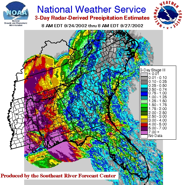
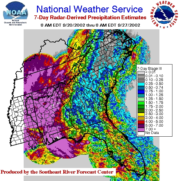
| 3-Day Peiod associated with Tropical Storm Isidore | 7-Day Period from Pre-Storm Event & TS Isidore |

