National Weather Service United States Department of Commerce


Tornadoes of December 29, 2021

Overview
 

A line of storms with embedded supercells developed south of an outflow boundary ahead of a slow-moving cold front Wednesday evening, producing damaging winds and two tornadoes across northern portions of Central Alabama. Further south, a discrete supercell moved out of Mississippi and eventually produced a tornado near the border of Chilton and Shelby Counties.

 
Interactive Tornado Map


**The data below are considered PRELIMINARY.**

Location/Clickable Detailed Summary Link
Damage Rating/Estimated Maximum Wind Speeds
Injuries/Fatalities
Damage Path Length/Width
Starting Point/Time
Ending Point/Time
Winfield Tornado
(Lamar/Marion Counties)
EF-1
110 mph
None 17.62 miles
300 yards
Crews
33.9167/-88.0816
6:27 pm CST
1 E Winfield
33.9307/-87.7764
6:47 pm CST
Glencoe Tornado
(Etowah County)
EF-0
75 mph

 
None 1.20 miles
100 yards
1 NNW Glencoe
33.9681/-85.9351
9:02 pm CST
1 NNE Glencoe
33.9741/-85.9155
9:04 pm CST
Chilton Tornado
(Chilton/Shelby Counties)
EF-1
110 mph

 
None 11.10 miles
400 yards
1 W Minooka Park
33.0444/-86.7754
10:01 pm CST
1 SSW Waxahatchee at Lay Lake
33.0492/-86.5879
10:19 pm CST
 
Winfield EF-1
 

Winfield EF-1 Tornado (Lamar & Marion Counties)
  December 29, 2021


Event Summary

EF-1
Estimated Maximum Wind:
110 mph
Injuries/Fatalities:
None
Damage Path Length:
17.62 miles
Maximum Path Width:
300 yards
Approximate Start Point/Time:
Crews
33.9167/-88.0816
at 6:27 pm CST
Approximate End Point/Time:
1 E Winfield
33.9307/-87.7764
at 6:47 pm CST


National Weather Service meteorologists surveyed the damage in northern Lamar County into extreme southern Marion County and determined it was the result of an EF-1 tornado.

A tornado touched down just southwest of the Beaverton community in Lamar county Wednesday evening. The tornado first touched down along Highway 278 with very minor tree damage noted. The tornado then moved almost due east across Highway 278 producing sporadic tree damage as it crossed Turkey Branch Road and Markham Road in far eastern Lamar County. A small barn was also damaged in this area. The tornado then straddled the Fayette and Marion county line with mostly softwood trees uprooted in this forested area. The tornado crossed County Road 69 moving completely into southern Marion county and into the western portions of Winfield. The most notable damage was in downtown Winfield as the tornado strengthened to EF-1 intensity. Here damage to several buildings in downtown was noted along Highway 43. Several businesses sustained roof and structural damage with windows being blown out of others. A strip mall lost a large section of its roof structure. The damage here was deemed 110 mph. The tornado was also at its widest going through downtown at approximately 300 yards wide. The tornado narrowed fairly rapidly as it exited downtown and began to wind down in the more residential areas east of town. Some homes sustained minor roof damage along Highway 43 near the Highway 129 intersection. Further east the tornado lifted with only sporadic minor tree damage noted. 


Radar Image
Reflectivity (left) and velocity (right) of the circulation before the tornado moved into Winfield.
Images are from KGWX at 6:41 pm CDT.


Damage Photo
 Structure Damage
Damage Photo
 Structure Damage
Damage Photo
 Structure Damage
 
Glencoe EF-0
 

Glencoe EF-0 Tornado (Etowah County)
  December 29, 2021


Event Summary

EF-0
Estimated Maximum Wind:
75 mph
Injuries/Fatalities:
None
Damage Path Length:
1.20 miles
Maximum Path Width:
100 yards
Approximate Start Point/Time:
1 NNW Glencoe
33.9681/-85.9351
at 9:02 pm CST
Approximate End Point/Time:
1 NNE Glencoe
33.9741/-85.9155
at 9:04 pm CST


National Weather Service meteorologists surveyed the damage in southern Etowah County near Glencoe and determined it was the result of an EF-0 tornado.

A brief EF0 tornado formed near Glencoe Middle School where some roof damage was observed. The tornado moved northeast across Lonesome Bend Road snapping a couple trees and causing shingle damage along Stone Street. It downed more trees, peeled back the roof a barn, and moved a travel trailer just west of Pineview Avenue. After crossing Pineview Avenue, it destroyed a small shed and caused roof damage to a home on Barron Way before dissipating.


Radar Image
Reflectivity (left) and velocity (right) of the brief circulation.
Images are from KHTX at 9:03 pm CST.


Damage Photo
 Structure Damage
Damage Photo
 Structure Damage
Damage Photo
 Roof Damage
 
Chilton EF-1
 

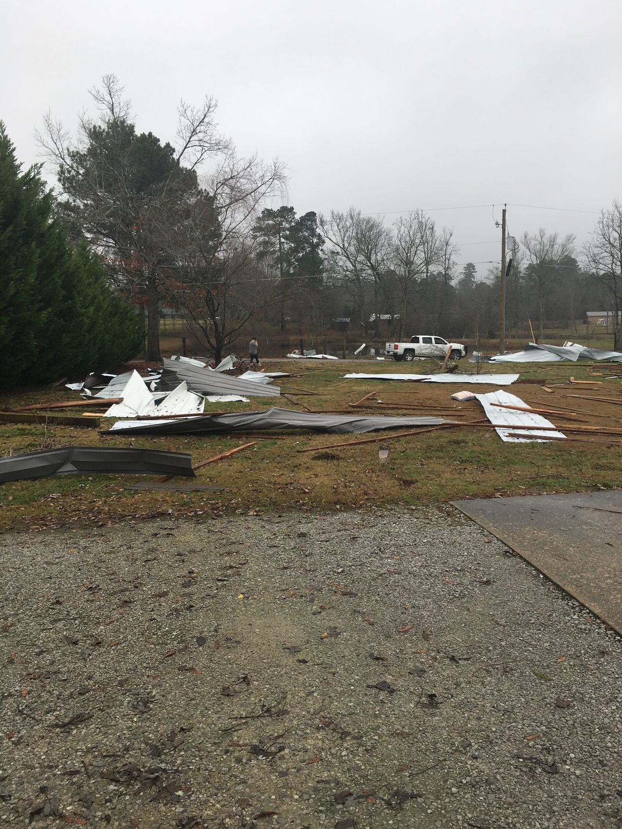
Chilton EF-1 Tornado (Chilton & Shelby Counties)
  December 29, 2021


Event Summary

EF-1
Estimated Maximum Wind:
110 mph
Injuries/Fatalities:
None
Damage Path Length:
11.85 miles
Maximum Path Width:
400 yards
Approximate Start Point/Time:
1 W Minooka Park
33.0444/-86.7754
at 10:01 pm CST
Approximate End Point/Time:
1 SSW Waxahatchee at Lay Lake
33.0492/-86.5879
at 10:19 pm CST


National Weather Service meteorologists surveyed the damage in extreme northern Chilton County south of Calera and determined it was the result of an EF-1 tornado.

The tornado touched down just west of County Road 33, a few miles south of the Chilton and Shelby County line. Before crossing County Road 33, the tornado uprooted and snapped several trees and at least 4 structures were damaged. The tornado traveled east northeast over US 31, and when it reached hunting property along County Road 800, it produced significant tree damage. The tornado continued east over rural northern Chilton County where it knocked down trees. The tornado lifted along AL 145 just inside the Shelby County line. The damage was very weak by the time it lifted. 


Radar Image
Reflectivity (left) and velocity (right) of the circulation before it crossed into Shelby County.
Images are from KBMX at 10:11 pm CST.


Damage Photo
 Tree Damage
Damage Photo
 Roof Damage
Damage Photo
 Roof Damage
 
Outlooks & Reports
 

Local Day 3 Outlook
Local Day 3 Outlook
Dec 27 at 5 am

Local Day 2 Outlook
Local Day 2 Outlook
Dec 28 at 5 am

Local Day 1 Outlook
Local Day 1 Outlook
Dec 29 at 9 am

Storm Reports
Storm Reports
Dec 29


Surface & Upper Air Charts
 

250mb Analysis
250mb Analysis
Dec 29 at 6 pm

500mb Analysis
500mb Analysis
Dec 29 at 6 pm

850mb Analysis
850mb Analysis
Dec 29 at 6 pm

KBMX Sounding
KBMX Sounding
Dec 29 at 6 pm

Flooding Photo
UAH Sounding
Dec 29 at 6 pm

Surface Analysis
Surface Analysis
Dec 29 at 3 pm

Surface Analysis
Surface Analysis
Dec 29 at 6 pm

Surface Analysis
Surface Analysis
Dec 29 at 9 pm

Surface Analysis
Surface Analysis
Dec 30 at 12 am