National Weather Service United States Department of Commerce

Tornadoes on December 22nd, 2011 


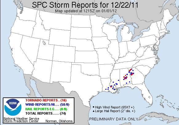
Event Summary for Central Alabama

As part of a week's worth of shortwave troughs coming out of the four-corners region of the southwest United States, Central Alabama was brought a piece of coal-like Christmas present in the way of severe weather. On the evening of Wednesday, December 21, this particular shortwave began moving towards the southeast United States. With the upper trough tilting negatively overnight, a surface low developed near New Orleans early in the morning of December 22 in response to this shortwave and trekked northeastward into Central Alabama. Dew points increased 20-25 degrees from the previous day, which greatly increased the surface based instability. This, coupled with the very high wind shear from the passing low, set up the perfect environment for tornadoes to develop. The highest instabilities were in the central and southeast portions of Central Alabama, and these areas were where the tornadoes eventually formed.  Fortunately, no one was injured in any of these tornadoes.

Preliminary Public Information Statement

The information below summarizes the tornadoes from this day, with each tornado path linked to its own webpage:

 
Location/Clickable Detailed Summary Link
Damage Rating/Estimated Maximum Wind Speeds
Injuries/Fatalities
Damage Path Length/Width
Starting Point/Time
Ending Point/Time
Centreville (Bibb County)
EF-0
70-80 mph
None
0.06 miles
25 yards
32.9053/-87.1224
12:56 pm
32.9053/-87.1224
12:57 pm
Lawley (Bibb County)
EF-0
80 mph
None
2.62 miles
150 yards
32.8692/-86.9742
1:25 pm
32.8796/-86.9307
1:28 pm
Dallas County
6 miles E of Selma
EF-0
85 mph
None
2.17 miles
50 yards
32.4232/-86.9206
1:30 pm
32.4305/-86.8844
1:33 pm
Columbiana
(Shelby County)
EF-0
70-80 mph
None
1.83 miles
50 yards
33.1828/-86.6070
1:42 pm
33.2027/-86.5860
1:45 pm
EF-0
85 mph
None
10.18 miles
100 yards
32.6203/-86.5478
2:02 pm
32.7019/-86.4059
2:16 pm
EF-1
90-100 mph
None
24.9 miles
300 yards
32.7438/-86.2996
2:24 pm
32.9902/-85.9920
2:52 pm


Pertinent Geographic Information Systems (GIS) Data from this Event


Severe Weather Episode Data 

500 mb Dec 21 6 pm
500 mb Analysis
Dec 21 at 6 pm
500 mb Dec 22 at 6 am
  500 mb Analysis
  Dec 22 at 6 am
Sfc Analysis 9 am
Surface Analysis
  Dec 22 9 am
Surface Analysis 12 pm
Surface Analysis
  Dec 22 12 pm
Day 2 Outlook 1130 am
Day 2 Severe Weather Outlook
Issued Dec 21 at 1130 am
Day 1 Outlook 7 am
Day 1 Severe Weather Outlook
Issued Dec 22 at 7 am
Storm Reports
Storm Reports 12/22/11
Storm Reports
Upper Air Sounding Dec 22 at 6 am