|
Event Summary
|
|
EF-2
|
|
Estimated Maximum Wind:
|
120 mph
|
|
Injuries/Fatalities:
|
3 Injuries |
|
Damage Path Length:
|
5.95 miles
|
|
Maximum Path Width:
|
350 yards
|
|
Approximate Start Point/Time:
|
2 SSE US 80 and AL 28
32.4206/-87.9787
at 807 pm
|
|
Approximate End Point/Time:
|
3 SSE McDowell
32.4809/-87.9061
at 816 pm
|
NWS Meteorologists surveyed damage in extreme northwest Marengo County just southwest of Demopolis and determined it was the result of a tornado.
The tornado first touched down along County Road 28 where very minor tree damage was noted on the east side of the road. The tornado then tracked northeast over mainly forested areas of Marengo county for several miles producing sporadic tree damage. The tornado widened and strengthened rapidly as it continued its northeast trek toward US Highway 80.
Here, the tornado reached its widest point at approximately 350 yards. Substantial tree damage was noted on both the north and south sides of Highway 80 along and near the intersection of County Road 57. A home sustained roof damage along County Road 57. The homeowner was home at the time and reported receiving the warning well before the storm hit. On the north side of US Highway 80, property and structural damage was extensive. Here several homes sustained roof and structural damage. One brick home sustained complete roof loss and partial wall collapse. The occupant, a 93 year old woman, reported receiving the warning on her phone and sheltering in an interior hallway before the storm hit. She was shaken up but unhurt.
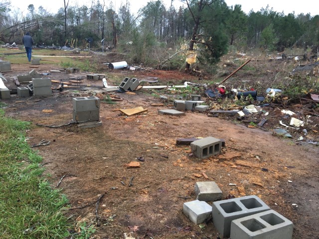
Just east of that location, a doublewide and singlewide mobile home on the same property were completely destroyed with the undercarriage of both blown a substantial distance. Inspection of both dwellings indicated little to no anchorage of the structures. Three people were reported injured at this location with one being airlifted for more serious injuries.
Tree damage in this area was extensive with large old growth hardwoods snapped. The combination of the damage to the conventional brick home, along with the tree damage and mobile home destruction, prompted the maximum wind rating of 120 mph. The tornado continued its northeast movement damaging additional structures north of Highway 80 before narrowing and weakening south of the Sumter County line and west of downtown Demopolis. The end point was estimated due to lack of survey accessibility in that area.
|