|
Tuscaloosa Tornado |
||||||||||||||||||||||||||||||||
|---|---|---|---|---|---|---|---|---|---|---|---|---|---|---|---|---|---|---|---|---|---|---|---|---|---|---|---|---|---|---|---|---|
|
Additional surveys and weather data from this day
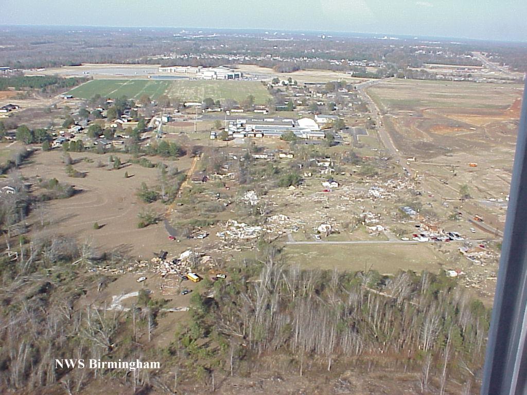
The tornado began in southwestern Tuscaloosa County on the west side of the Warrior River. Traveling in a northeasterly direction the tornado moved from a rural, unpopulated area of the Warrior River into an area of homes south of Shelton State Community College. The tornado crossed SR 69 destroying a nearly complete shopping center which included a Winn Dixie store. East of SR 69 the tornado destroyed a number of houses and residential structures. As the tornado reached US 82 it destroyed a number of mobile homes where several deaths were reported. From US 82 the tornado continued northeasterly knocking down numerous trees and power lines and damaging residential structures. The tornado crossed I-20/59 between exits 76 and 77 where many trees were uprooted or snapped off. Minor damage occurred to the JVC manufacturing facility. At exit 77, a number of commercial structures including hotels, fast food restaurants, and truck stops sustained damage including a number of vehicles that were overturned. The tornado continued northeasterly for a couple of miles before dissipating rapidly. Ironically, the tornado dissipated as it moved into an open, unpopulated area. The tornado was spawned by a supercell thunderstorm that originated in Mississippi. This thunderstorm was responsible for additional tornado damage in St. Clair and Etowah counties for which additional storm surveys are available. Tuscaloosa EMA reported 11 fatalities with this tornado along with 144 injuries. Nine of the fatalities occurred in mobile homes, one in a vehicle, and one in a commercial building converted to residential use. Six of those killed were females and five were males. Ages ranged from 16 months to 83 years old. The tornado was on the ground for a total of 18 miles, all within Tuscaloosa county. The tornado path was estimated to be 750 yards wide at it's maximum intensity. This tornado was rated an F4 on the Fujita Scale for tornado intensity. Tornado intensity varied along the path with considerable F2 and F3 damage in the area from just west of SR 69 to US 82 in the Hinton Place and Hillcrest Meadows areas as well as the Bear Creek area. It was also in these areas where pockets of F4 destruction occurred. Tornadoes are rated with the highest F-scale rating along the track. An update to the original F-scale was implemented on February 1, 2007, and is now known as the EF-scale. The tornado first touched down at 12:54 PM and dissipated at 1:12 PM with a forward speed of approximately 60 MPH. Tornado Watch Number 808 was issued at 10:00 AM that included Tuscaloosa County. A Tornado Warning was issued for Tuscaloosa County at 12:40 PM which triggered the outdoor warning sirens to be sounded. This tornado and the associated fatalities have set some dubious records for Alabama. This is the deadliest tornado so far this year in the state. It also ties a Georgia tornado earlier this year as the deadliest tornado in the United States in 2000. The 11 fatalities also move Alabama into third place nationwide in total tornado deaths since 1950. The state is third behind Texas and Mississippi. This tornado also becomes the strongest tornado recorded in December in Alabama since 1950, and it is the strongest tornado recorded in Tuscaloosa County since 1950.
Special thanks is extended to the Tuscaloosa Police Department and the Tuscaloosa Emergency Management Agency for providing the helicopter for making the aerial survey of the devastating tornado. Additional thanks goes to Captain Harold Jones of the Tuscaloosa Police Department for his excellent work as the helicopter pilot and for his advance work in accurately defining the tornado track even before National Weather Service personnel flew with him.
|
|
||||||||||||||||||||||||||||||