National Weather Service United States Department of Commerce


Tornadoes of March 30, 2022

Overview
 

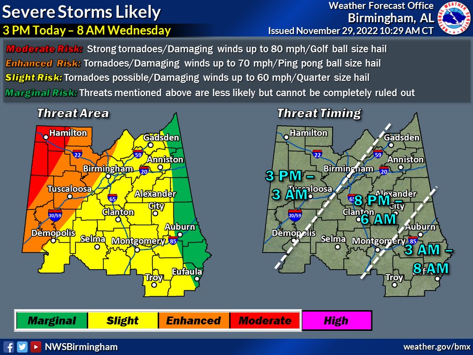
Tuesday, November 29, 2022, got off to a cold start across Central Alabama as the area observed morning low temperatures in the 30s and 40s. Some locations even dropped to freezing near daybreak. However, the atmosphere was able to allow for a quick warm-up that day as an area of low pressure advanced northeast through the Mississippi River Valley. This allowed for southeasterly to southerly low-level winds to transport warm, moist air from the Gulf of Mexico northward through the Lower Mississippi and Tennessee Valleys. The combination of southerly flow and some sunshine allowed for temperatures to rise well into the 70s by the afternoon hours. As a result, showers and thunderstorms began to develop in the region.

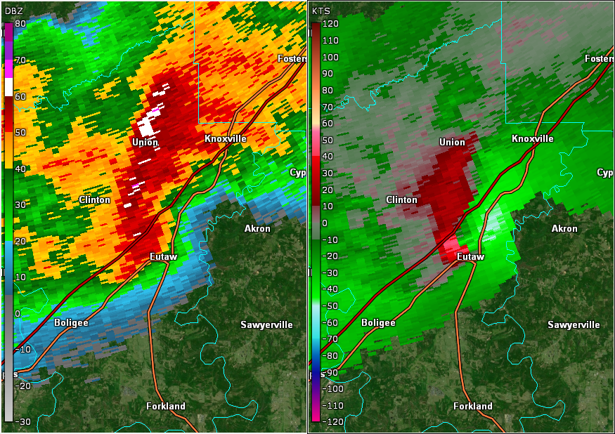
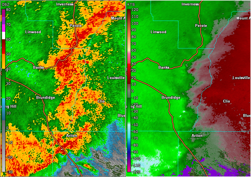
The first round of these were elevated in nature as a warm front at 850 mb moved into the area. However, as surface dewpoints continued to increase into the 60s during the late afternoon, instability became more surface-based. Additional thunderstorms continued to develop across portions of Louisiana and Mississippi during this time. Given an abundance of wind shear in the atmosphere that afternoon, many thunderstorms became supercells. These strong to severe thunderstorms eventually made their way into Central Alabama Tuesday evening carrying a threat of damaging winds, large hail, and tornadoes.

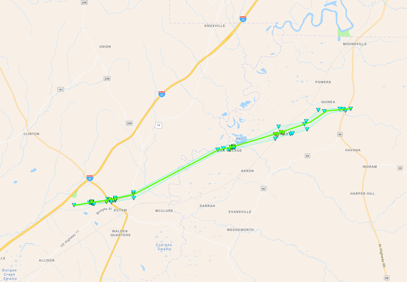
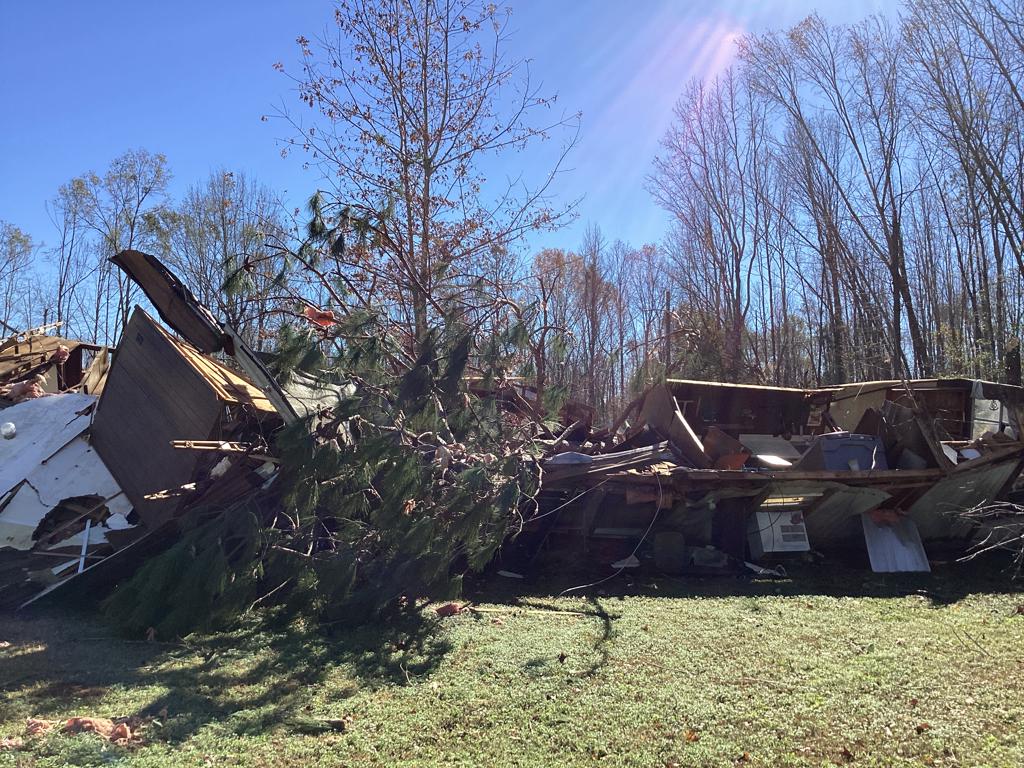
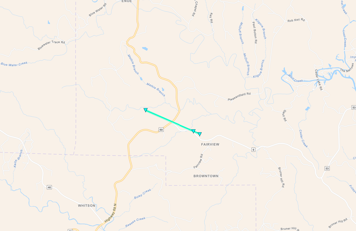
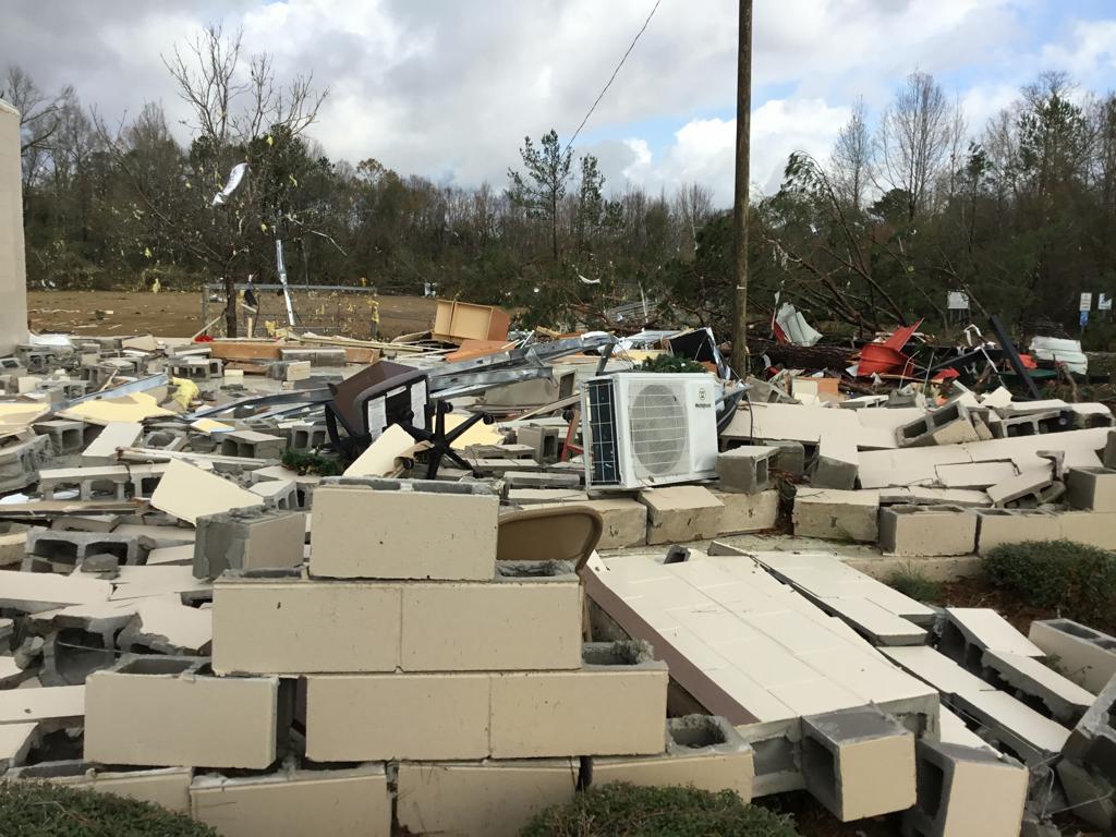
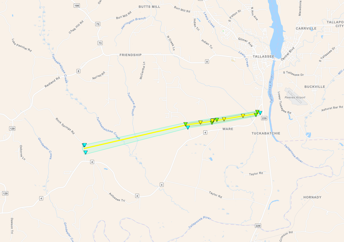
Thunderstorm activity also led to heavy rainfall into the morning hours of Wednesday, November 30, 2022. This caused flash flooding in the Birmingham area. Locations along and north of Interstate 20 received 2 to 5 inches of rainfall, some locally higher. Overall, many communities were impacted as these strong to severe thunderstorms moved along and ahead of an advancing cold front. In total, 10 tornadoes were documented in Central Alabama, along with numerous wind damage and hail reports. Unfortunately, one EF-2 tornado claimed the lives of two Central Alabama residents and resulted in 2 injuries in Montgomery County.


View Larger Map

 
Surveys
 

**The data below are considered PRELIMINARY.**

 
Location/Clickable Detailed Summary Link
Damage Rating/Estimated Maximum Wind Speeds
Injuries/Fatalities
Damage Path Length/Width
Starting Point/Time
Ending Point/Time
Eutaw-Oak Village Tornado
(Greene/Hale Counties)
EF-1
110 mph
None 19.49 miles
1200 yards
1 S I-20 Rest Area near Eutaw
32.8445/-87.9401
9:44 pm CST on Nov 29th
2 SSE Moundville Airport
32.9362/-87.6270
10:13 pm CST on Nov 29th
Tutwiler Road Tornado
(Walker County)
EF-0
65 mph

 
None 1.99 miles
50 yards
1 WNW The Wye
33.6237/-87.3830
12:28 am CST on Nov 30th
1 ESE The Wye
33.6122/-87.3514
12:30 am CST on Nov 30th
Locust Fork Tornado
(Blount County)
EF-0
65 mph
None 3.46 miles
500 yards
2 E Mount Olive
33.9149/-86.6725
12:57 am CST on Nov 30th
Locust Fork
33.9156/-86.6126
1:02 am CST on Nov 30th
Wayne Tornado
(Marengo County)
EF-1
110 mph
None 15.49 miles
525 yards
3 SW Sweet Water
32.0608/-87.9057
1:11 am CST on Nov 30th
2 NNW Magnolia
32.1683/-87.6753
1:30 am CST on Nov 30th
Mudd Street Tornado
(Calhoun County)
EF-0
75 mph
None 0.79 miles
300 yards
5 NNW Eastaboga
33.6806/-86.0640
1:37 am CST on Nov 30th
6 NNW Eastaboga
33.6878/-86.0539
1:38 am CST on Nov 30th
Flatwood-Willow Springs Tornado
(Elmore/Montgomery Counties)
EF-2
120 mph
2 Fatalities
2 Injuries
9.92 miles
650 yards
3 W Boylston
32.4385/-86.3318
3:14 am CST on Nov 30th
1 ESE Blue Ridge
32.4758/-86.1688
3:28 am CST on Nov 30th
New Quarter Road Tornado
(Elmore County)
 
EF-2
115 mph
None 6.26 miles
400 yards
3 NE Ware
32.4892/-86.0017
3:38 am CST on Nov 30th
1 WSW Reeves Airport
32.5071/-85.8966
3:49 am CST on Nov 30th
Buckhorn Tornado
(Pike County)
EF-0
70 mph
None 1.42 miles
150 yards
Monticello
31.8216/-85.7711
5:42 am CST on Nov 30th
2 E Monticello
31.8181/-85.7474
5:44 am CST on Nov 30th
Barefoot Road Tornado
(Pike County)
EF-0
75 mph
None 0.79 miles
150 yards
4 N Tennille
31.6823/-85.7535
5:45 am CST on Nov 30th
4 SE Brundidge Municipal Airport
31.6881/-85.7420
5:46 am CST on Nov 30th
Texasville Tornado
(Barbour County)
EF-0
80 mph
None 6.60 miles
300 yards
3 NE Tyler Crossroads
31.7385/-85.4857
6:06 am CST on Nov 30th
3 NE Texasville
31.7409/-85.3736
6:17 am CST on Nov 30th
 
Eutaw-Oak Village EF-1
 

Eutaw - Oak Village EF-1 Tornado (Greene & Hale Counties)
  November 29, 2022


Event Summary

EF-1
Estimated Maximum Wind:
110 mph
Injuries/Fatalities:
None
Damage Path Length:
19.49 miles
Maximum Path Width:
1200 yards
Approximate Start Point/Time:
1 S I-20 Rest Area near Eutaw
32.8445/-87.9401
at 9:44 pm CST
Approximate End Point/Time:
2 SSE Moundville Airport
32.9362/-87.6270
at 10:13 pm CST


National Weather Service meteorologists surveyed damage in eastern Greene County and determined that it was consistent with an EF1 tornado, with maximum winds near 110 mph.

The tornado touched down in an inaccessible area west of Eutaw shortly before crossing Greene CR 131 where it impacted the Sagewood Apartment complex. The most significant damage here was to the northernmost unit where the majority of the roof structure was peeled away and blown into the nearby tree line. Adjacent units only showed minor damage to shingles and to siding. Nearby timber damage was also not particularly intense, though there was a variety of sporadic uprooted and snapped tree trunks. Timber and powerline damage in this area was consistent with low-end EF-1. The tornado continued east-northeast toward Hwy 14 where additional timber and power line damage was observed. Several homes sustained minor roof damage on Kirkwood Lane or were more significantly damaged by uprooted trees. The tornado crossed Hwy 11 causing additional tree damage. The tornado continued northeast towards the Black Warrior River where the path became inaccessible. The first section of observable damage in Hale County was in the Oak Village Community northwest of Akron. Several homes sustained significant damage near the riverfront where impressive timber damage was observed. The tornado continued northeast toward Stewart where additional timber damage was observed along Hwy 42. A home sustained roof damage on Mileous Chapel Road. Near this area timber damage became very diverse in direction and damage intensity. The tornado was at its widest point here with a width around 1,200 yards. Based on the nature of the damage it is believed to have been in a multi-vortex state. The tornado then continued northeast and began to weaken with minor timber damage on Massey Loop Road. The tornado dissipated shortly after crossing Hwy 69. 

Tornado Track Map


Radar Image
Reflectivity (left) and velocity (right) as the tornado moved through Eutaw.
Images are from KGWX at 9:47 pm CST.


Damage Photo
 Manufactured Home Destroyed
Damage Photo
 Manufactured Home Damaged
Damage Photo
 Home Damaged
Damage Photo
 Tree Damage
Damage Photo
 Apartments Damaged
 
Tutwiler Rd EF-0
 

Tutwiler Road EF-0 Tornado (Walker County)
  November 30, 2022


Event Summary

EF-0
Estimated Maximum Wind:
65 mph
Injuries/Fatalities:
None
Damage Path Length:
1.99 miles
Maximum Path Width:
50 yards
Approximate Start Point/Time:
1 WNW The Wye
33.6237/-87.3830
at 12:28 am CST
Approximate End Point/Time:
1 ESE The Wye
33.6122/-87.3514
at 12:30 am CST


A NWS Birmingham survey team was able to find very minor and spatially isolated timber damage along Tutwiler Rd. This was the only damage observed on the survey. RADAR indicated a TVS and subsequent TDS northwest of AL Hwy 69 in an inaccessible area. The weak, brief, narrow tornado caused little consequence.  

Tornado Track Map


Radar Image
Reflectivity (left) and velocity (right) just before the tornado lifted.
Images are from KBMX at 12:30 am CST.


Locust Fork EF-0
 

Locust Fork EF-0 Tornado (Blount County)
  November 30, 2022


Event Summary

EF-0
Estimated Maximum Wind:
65 mph
Injuries/Fatalities:
None
Damage Path Length:
3.46 miles
Maximum Path Width:
500 yards
Approximate Start Point/Time:
3 E Mount Olive
33.9149/-86.6725
at 12:57 am CST
Approximate End Point/Time:
Locust Fork
33.9156/-86.6126
at 1:02 am CST


A NWS Birmingham storm survey team found damage in the Locust Fork area of Blount County consistent with an EF-0 tornado. The tornado potentially formed formed in a heavily wooded area near the Locust Fork River, just west of Standridge Trail. The first observable damage was in the area of Standridge Trail where minor timber damage occurred. Two barns sustained roof damage and one camper trailer was rolled and destroyed. The tornado continued east toward Deaver Walker and Campbell Roads. The circulation was fairly broad. Most damage consisted of sporadic tree fall, either uproots or the occasional snapped trunk. Most locations along Campbell Rd had large branches taken out of trees. A few structures had minor roof damage with at least two structures damaged by tree fall. The tornado moved generally east across Tabernacle Rd and County Rd 13 producing additional sporadic and minor timber damage. The tornado dissipated before crossing Hwy 79 as no observable damage was found downstream of there. Given the weak nature of the circulation, most if not all damage was on the right side with debris facing in a N to NE direction indicating non-divergent damage relative to path. No damage was found on the north side of the damage path. 

Tornado Track Map


Radar Image
Reflectivity (left) and velocity (right) just after the tornado touched down.
Images are from KBMX at 12:59 am CST.


Wayne EF-1
 

Wayne EF-1 Tornado (Marengo County)
  November 30, 2022


Event Summary

EF-1
Estimated Maximum Wind:
110 mph
Injuries/Fatalities:
None
Damage Path Length:
15.49 miles
Maximum Path Width:
525 yards
Approximate Start Point/Time:
3 SW Sweet Water
32.0608/-87.9057
at 1:11 am CST
Approximate End Point/Time:
2 NNW Magnolia
32.1683/-87.6753
at 1:30 am CST


The tornado began in a wooded area southeast of County Road 6 to the southwest of Sweet Water in southern Marengo County. Tree damage was initially minor as it moved northeastward, with portions of roofs removed from a couple outbuildings as well as a patio overhang from a residence along Dogwood Lane and County Road 7. Damage was barely discernible as it moved northeast across Highway 10, but the tornado intensified as it crossed
Sweetwater Creek. Numerous trees were snapped near Wayne Road; one of which was blown into and damaged the exterior wall of a doublewide manufactured home where a resident was not injured. Damage to the manufactured home probably would have been much worse if it had not been well-anchored and had its roof attached with clips. A camper was also moved several feet. The tornado continued to snap and uproot trees as it crossed Union Grove Road and caused shingle and window damage to a residence. Tree damage was minor across Highway 43, but the tornado intensified again as it crossed Pillie Road and County Road 73. The tornado removed the roof from an addition to a manufactured home along County Road 47 before dissipating prior to reaching Highway 25.


Tornado Track Map


Radar Image
Reflectivity (left) and velocity (right) of the tornado.
Images are from KBMX at 1:23 am CST.


Damage Photo
 Structure Damage
Damage Photo
 Camper Damaged
 
Mudd St EF-0
 

Mudd Street EF-0 Tornado (Calhoun County)
  November 30, 2022


Event Summary

EF-0
Estimated Maximum Wind:
75 mph
Injuries/Fatalities:
None
Damage Path Length:
0.79 miles
Maximum Path Width:
300 yards
Approximate Start Point/Time:
5 NNW Eastaboga
33.6806/-86.0640
at 1:37 am CST
Approximate End Point/Time:
6 NNW Eastaboga
33.6878/-86.0539
at 1:38 am CST


NWS Birmingham storm survey team assessed timber damage in a relatively localized area on Mudd Street. Timber damage consisted of several uprooted trees, several snapped trunks and several trees having large branches removed from their tops. All debris and tree fall was oriented N to NNE. Although this was a short-lived tornado and short path, overall damage is consistent with a brief EF-0 tornado with max wind of 75 mph. The tornado began near the intersection of Mayfield Rd and Mitchellville Rd then moved northeast toward Mudd St where the most severe damage occurred at two residences. Two homes also sustained minor roof damage. The tornado likely dissipated as it moved into a heavily wooded area as no further damage was observed at downstream road crossings. This event is also associated with evidence of a TDS off of KBMX RADAR, originating directly downstream from the damage location. 

Tornado Track Map


Radar Image
Reflectivity (left) and velocity (right) of the brief tornado.
Images are from KBMX at 1:37 am CST.


Flatwood-Willow Springs EF-2
 

Fatwood-Willow Springs EF-2 Tornado (Elmore/Montgomery Counties)
  November 30, 2022


Event Summary

EF-2
Estimated Maximum Wind:
120 mph
Injuries/Fatalities:
2 Fatalities / 2 Injuries
Damage Path Length:
9.92 miles
Maximum Path Width:
650 yards
Approximate Start Point/Time:
3 W Boylston
32.4385/-86.3318
at 3:14 am CST
Approximate End Point/Time:
1 ESE Blue Ridge
32.4758/-86.1688
at 3:28 am CST


The tornado began in southwest Elmore County west of the Alabama River Parkway where an outbuilding and retaining wall were damaged. It crossed the Alabama River into Montgomery County north of the toll bridge downing trees north of the Alabama River Parkway. It continued east-northeastward, downing trees along Coosada Ferry Road. It strengthened as it reached Williams Drive, where part of the roof of a shop was removed and an unanchored manufactured home was rolled over with the occupant suffering minor injuries. The tornado continued to snap and uproot trees along Williams Drive, while a manufactured home and a residence suffered roof damage. Just west of Franson Road two manufactured homes were completely destroyed with debris blown downstream. One manufactured home had some evidence of straps but the occupancy status of both are unknown. As the tornado moved into the Flatwood community, many homes had roof damage and damage from falling trees. Unfortunately an uprooted tree fell on a manufactured home, resulting in two fatalities and one serious injury. The concrete masonry unit community center also suffered collapse of all exterior walls. The tornado crossed Lower Wetumpka Road twice, continuing to snap and uproot trees and cause roof damage, with one home suffering complete roof loss. A couple wooden transmission line poles fell north of Anderson Road. The tornado then crossed the Tallapoosa River back into Elmore County. An impressive swath of trees were downed on the west side of Highway 231. The tornado continued northeastward along Jasmine Hill Road and Willow Springs Road, where several homes were damaged from falling trees. The tornado finally dissipated south of Willow Springs Road east of Ross Ridge Lane. 

Tornado Track Map


Radar Image
Reflectivity (left) and velocity (right) as the tornado crossed Lower Wetumpka Rd.
Images are from KMXX at 3:21 am CST.


Damage Photo
 Structure Damage
Damage Photo
 Structure Damage
Damage Photo
 Home Damaged
Damage Photo
 Manufactured Home Destroyed
Damage Photo
 Manufactured Home Destroyed
Damage Photo
 Tree Damage
 
New Quarter Rd EF-2
 

New Quarter Road EF-2 Tornado (Elmore County)
  November 30, 2022


Event Summary

EF-2
Estimated Maximum Wind:
115 mph
Injuries/Fatalities:
None
Damage Path Length:
6.26 miles
Maximum Path Width:
400 yards
Approximate Start Point/Time:
3 NE Ware
32.4892/-86.0017
at 3:38 am CST
Approximate End Point/Time:
1 WSW Reeves Airport
32.5071/-85.8966
at 3:49 am CST


The tornado began in southeast Elmore County along Rock Springs Road north of Rifle Range Road, downing branches and causing damage to an outbuilding. It continued northeastward through inaccessible forest, before snapping and uprooting trees along Dark Corners Road and New Quarter Road. Much of the roof of a home was removed along New Quarter Road with one exterior wall collapsing. It continued northeastward downing more trees along Rifle Range Road before dissipating prior to reaching Highway 229. Aerial imagery indicated occasional more impressive swaths of down trees both west and east of New Quarter Road. 

Tornado Track Map


Radar Image
Reflectivity (left) and velocity (right) just after the tornado crossed the Tumkeehatchee Creek .
Images are from KMXX at 3:42 am CST.


Damage Photo
 Structure Damage
Damage Photo
 Debris
 
Buckhorn EF-0
 

Buckhorn EF-0 Tornado (Pike County)
  November 30, 2022


Event Summary

EF-0
Estimated Maximum Wind:
70 mph
Injuries/Fatalities:
None
Damage Path Length:
1.42 miles
Maximum Path Width:
150 yards
Approximate Start Point/Time:
Monticello
31.8216/-85.7711
at 5:42 am CST
Approximate End Point/Time:
2 E Monticello
31.8181/-85.7474
at 5:44 am CST


A brief EF0 tornado developed within a quasi-linear convective system along County Road 6643 just east of Highway 130 and the Buckhorn community in northeastern Pike County. Damage consisted of a few uprooted trees and broken branches along County Road 6643. The tornado dissipated as it crossed Buckhorn Creek. A TDS was evident on KEOX radar. 

Tornado Track Map


Radar Image
Reflectivity (left) and velocity (right) just after the tornado lifted.
Images are from KEOX at 5:45 am CST.


Barefoot Rd EF-0
 

Barefoot Road EF-0 Tornado (Pike County)
  November 30, 2022


Event Summary

EF-0
Estimated Maximum Wind:
75 mph
Injuries/Fatalities:
None
Damage Path Length:
0.79 miles
Maximum Path Width:
150 yards
Approximate Start Point/Time:
4 N Tennille
31.6823/-85.7535
at 5:45 am CST
Approximate End Point/Time:
4 SE Brundidge Municipal Airport
31.6881/-85.7420
at 5:46 am CST


A brief EF0 tornado touched down in the woods between Ten Mile Road and Barefoot Road at approximately 5:45 AM. As the tornado approached Barefoot Road, numerous pine trees received large limb damage. The tornado crossed Barefoot Rd and caused more tree damage. The tornado lifted quickly between Barefoot road and Pike County Road 4420, sparing a number of chicken barns that lie ahead in its path. 

Tornado Track Map


Radar Image
Reflectivity (left) and velocity (right) of the brief tornado.
Images are from KEOX at 5:45 am CST.


Texasville EF-0
 

Texasville EF-0 Tornado (Barbour County)
  November 30, 2022


Event Summary

EF-0
Estimated Maximum Wind:
80 mph
Injuries/Fatalities:
None
Damage Path Length:
6.60 miles
Maximum Path Width:
300 yards
Approximate Start Point/Time:
3 NE Tyler Crossroads
31.7385/-85.4857
at 6:06 am CST
Approximate End Point/Time:
3 NE Texasville
31.7409/-85.3736
at 6:17 am CST


An EF0 tornado touched down in the woods between Stark Brothers Road and Barbour County Road 53 just northeast of Texasville at approximately 6:06 AM. As the tornado crossed CR 53, a few pine tree tops were snapped. The tornado continued eastward to the intersection of AL Highway 131 and CR 20, where another top of a pine tree was snapped and fell into the roadway of AL Hwy 131, causing a motor vehicle accident. Large limbs were broken to the north of AL Hwy 131 and west of CR 20. From there the tornado paralleled AL Hwy 131 as it traveled east before striking a chicken farm. It caused significant damage to all 4 chicken houses, with large sections of barn roofing removed and blown as much as 200 yards. The tornado continued across the farm through mainly open fields uprooting a few large trees, and then causing minor damage to a riding arena and the farmhouse. The tornado crossed CR 67 and uprooted a few pine trees before dissipating quickly. 

Tornado Track Map


Radar Image
Reflectivity (left) and velocity (right) a couple moments after the tornado touched down.
Images are from KEOX at 6:08 am CST.


Damage Photo
 Chicken Houses Damaged
Damage Photo
 Debris
 
Outlooks & Reports
 

Day 3 Outlook
Local Day 3 Outlook
November 27 at 4 am

Day 2 Outlook
Local Day 2 Outlook
November 28 at 1140 am

Day 1 Outlook
Local Day 1 Outlook
November 29 at 1030 am

Day 3 Outlook
Storm Reports
November 29th

   
Surface Charts
 

Surface Chart
Surface Analysis
November 29 at 3 pm

Surface Chart
Surface Analysis
November 29 at 6 pm

Surface Chart
Surface Analysis
November 29 at 9 pm

Surface Chart
Surface Analysis
November 30 at 12 am

Surface Chart
Surface Analysis
November 30 at 3 am

Surface Chart
Surface Analysis
November 30 at 6 am

Surface Chart
Surface Analysis
November 30 at 9 am

   
Upper Air Charts
 

250 mb
250 mb Analysis
November 29 at 6 pm

500 mb
500 mb Analysis
November 29 at 6 pm

850 mb
850 mb Analysis
November 29 at 6 pm

250 mb
250 mb Analysis
November 30 at  am

500 mb
500 mb Analysis
November 30 at 6 am

850 mb
850 mb Analysis
November 30 at 6 am

KBMX Sounding
KBMX Sounding
November 29 at 6 pm

KBMX Sounding
UAH SWIRLL Sounding
November 29 at 8 pm

KBMX Sounding
KBMX Sounding
November 30 at 6 am