Pike & Barbour County Tornadoes
November 27, 2019
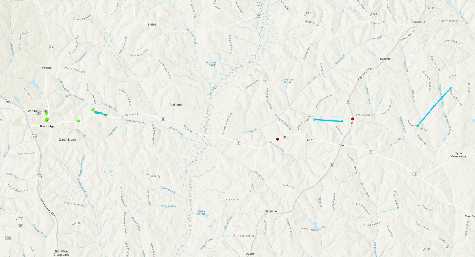
Map of the tornado tracks. |
|
|
|
Troy Street EF-0 Tornado (Pike County)
November 27, 2019
|
Event Summary
|
|
EF-0
|
|
Estimated Maximum Wind:
|
70 mph
|
|
Injuries/Fatalities:
|
None |
|
Damage Path Length:
|
0.48 miles
|
|
Maximum Path Width:
|
65 yards
|
|
Approximate Start Point/Time:
|
2 ENE Brundidge
31.7283/-85.7842
at 905 am
|
|
Approximate End Point/Time:
|
2 ENE Brundidge
31.7266/-85.7764
at 906 am
|
NWS Meteorologists surveyed damage in southeastern Pike County just northeast of Brundidge and determined it was the result of a brief tornado.
The tornado touched down in an open field just east of CR81 and north of Alabama Highway 10. The first indicated damages were the tin roof being removed from an older manufactured home and an uprooted hardwood. The tornado moved east-southeastward and struck a much newer manufactured home which was slightly shifted off its supports, and sustained skirting damage and a broken picture window. There was also light splatter on all four sides of the home. The tornado continued ESE, producing minor small limb damage as it crossed Alabama Highway 10. The tornado then uprooted 5 healthy pecan trees, with a slightly convergent pattern. Another hardwood was uprooted just off the shoulder north of Alabama Highway 10, also indicative of convergence. The tornado dissipated rapidly past this point and produced no further damage.
|
|
|
![]() |
|
|
![]() |
|
Foulk Creek EF-0 Tornado (Barbour County)
November 27, 2019
|
Event Summary
|
|
EF-0
|
|
Estimated Maximum Wind:
|
60 mph
|
|
Injuries/Fatalities:
|
None |
|
Damage Path Length:
|
1.15 miles
|
|
Maximum Path Width:
|
40 yards
|
|
Approximate Start Point/Time:
|
2 NW Clio
31.7240/-85.6294
at 919 am
|
|
Approximate End Point/Time:
|
1 N Clio
31.7231/-85.6099
at 921 am
|
NWS Meteorologists surveyed damage in southwest Barbour County near Clio and determined it was the result of a weak tornado.
Doppler RADAR showed a tornado debris signature (TDS) associated with an area of rotation as the cell moved eastward into far southwestern Barbour County. Minor single-point damage was noted on Alabama Highway 10 as well as on Highway 51, west and north of Clio, respectively. Between these 2 points, a TDS was noted on radar in an area that was inaccessible. Given RADAR evidence plus the tornadic nature of the storm with tracks 1 and 3, a brief EF-0 track was assigned to an area on the northwest side of Clio. Tornado intensity was estimated using velocity strength and TDS height.
|
|
|
![]() |

Reflectivity (left) and velocity (right) as the tornado touched down.
Images are from KEOX at 919 am. |
|
|
|
![]() |
|
Baxter Station Road EF-0 Tornado (Barbour County)
November 27, 2019
|
Event Summary
|
|
EF-0
|
|
Estimated Maximum Wind:
|
65 mph
|
|
Injuries/Fatalities:
|
None |
|
Damage Path Length:
|
2.13 miles
|
|
Maximum Path Width:
|
55 yards
|
|
Approximate Start Point/Time:
|
3 ENE Clio
31.7199/-85.5568
at 926 am
|
|
Approximate End Point/Time:
|
5 ENE Clio
31.7432/-85.5330
at 930 am
|
NWS Meteorologists surveyed damage in southwest Barbour County just northeast of Clio and determined it was the result of a weak tornado.
A third and final brief EF-0 tornado occurred just east of Clio. Only minor tree damage was observed along its path, which began near the intersection of Baxter Station Road and CR23 and ended to the northeast along Blue Springs Road.
|
|
|
![]() |

Reflectivity (left) and velocity (right) as the tornado crossed Blue Spring Rd.
Images are from KEOX at 928 am. |
|
|
|
![]() |


