NWS Birmingham, Alabama
Weather Forecast Office
Barfield Tornado...November 24, 2001
The start of this F1 tornado was approximately one mile east of AL 9 on County Road 58, with a roof torn off a barn. On Black's Chapel road near Black's Chapel, several trees were snapped at mid-trunk. Black's Chapel itself had the steeple torn off, with additional roof damage. Across the street, there was extensive damage, with a barn destroyed. A path of damage extended across Ingram Road, 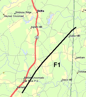 Wakefield Road, across Foster's Bridge Road, to Monroe. Several barns were destroyed, with widespread tree damage. The storm track continued northeast across Mt Moriah Road (County Road 58), and crossed into Randolph County along County Road 82, for less than a mile. The tornado appeared to have a wide path of damage, up to 300 yards at the widest point, and had a length of approximately 6.5 miles. Witnesses in the area reported hearing the load roaring, or "freight train" noise as the storm passed. Wakefield Road, across Foster's Bridge Road, to Monroe. Several barns were destroyed, with widespread tree damage. The storm track continued northeast across Mt Moriah Road (County Road 58), and crossed into Randolph County along County Road 82, for less than a mile. The tornado appeared to have a wide path of damage, up to 300 yards at the widest point, and had a length of approximately 6.5 miles. Witnesses in the area reported hearing the load roaring, or "freight train" noise as the storm passed.The tornado first touched down at approximately 5:15 PM CST, and entered into Randolph County approximately 5:22 PM CST, dissipating shortly thereafter. The first Tornado Warning was issued for Clay County was at 4:10 PM CST and was valid until 5:00 PM CST. A second Tornado Warning was issued at 5:00 PM CST, valid until 5:45 PM CST. A Severe Thunderstorm Warning was issued for Northwest Randolph county at 5:18 PM CST, valid until 5:45 PM CST. A Tornado Warning was issued for Randolph County at 5:40 PM CST, and was in effect until 6:15 PM CST. Tornado Watch 820 was in effect at the time of the tornado, and was issued at 1:53 PM CST. |
Current Hazards
National Outlooks
Tropical
Local Storm Reports
Public Information Statement
Graphical Hazardous Weather Outlook
Current Conditions
Regional Weather Roundup
Rivers and Lakes
Drought Monitor
Forecasts
Forecast Discussion
Air Quality
Fire Weather
Aviation Weather
Graphical Forecasts
Climate and Past Weather
Past Events
Storm Data
Tornado Database
Daily Rainfall Plots
Tropical Cyclone Reports
Warnings and Other Products
Tornado Warnings
Severe Thunderstorm Warnings
Flash Flood Warnings
Winter Weather Warnings
Special Weather Statements
Non-Precipitation Warnings
Flood/River Flood Warnings
Productos en Español
Conciencia y Preparación
Previsión de 7 Días
Weather Safety
NOAA Weather Radio
Severe Weather Preparedness
Severe Safety Rules
Tornado Safety Rules
Severe Safety w/ ASL
Awareness Weeks
Severe Weather
Hurricane Preparedness
Summer Safety Campaign
Winter Weather
US Dept of Commerce
National Oceanic and Atmospheric Administration
National Weather Service
NWS Birmingham, Alabama
465 Weathervane Road
Calera, AL 35040
205-664-3010
Comments? Questions? Please Contact Us.

