NWS Birmingham, Alabama
Weather Forecast Office
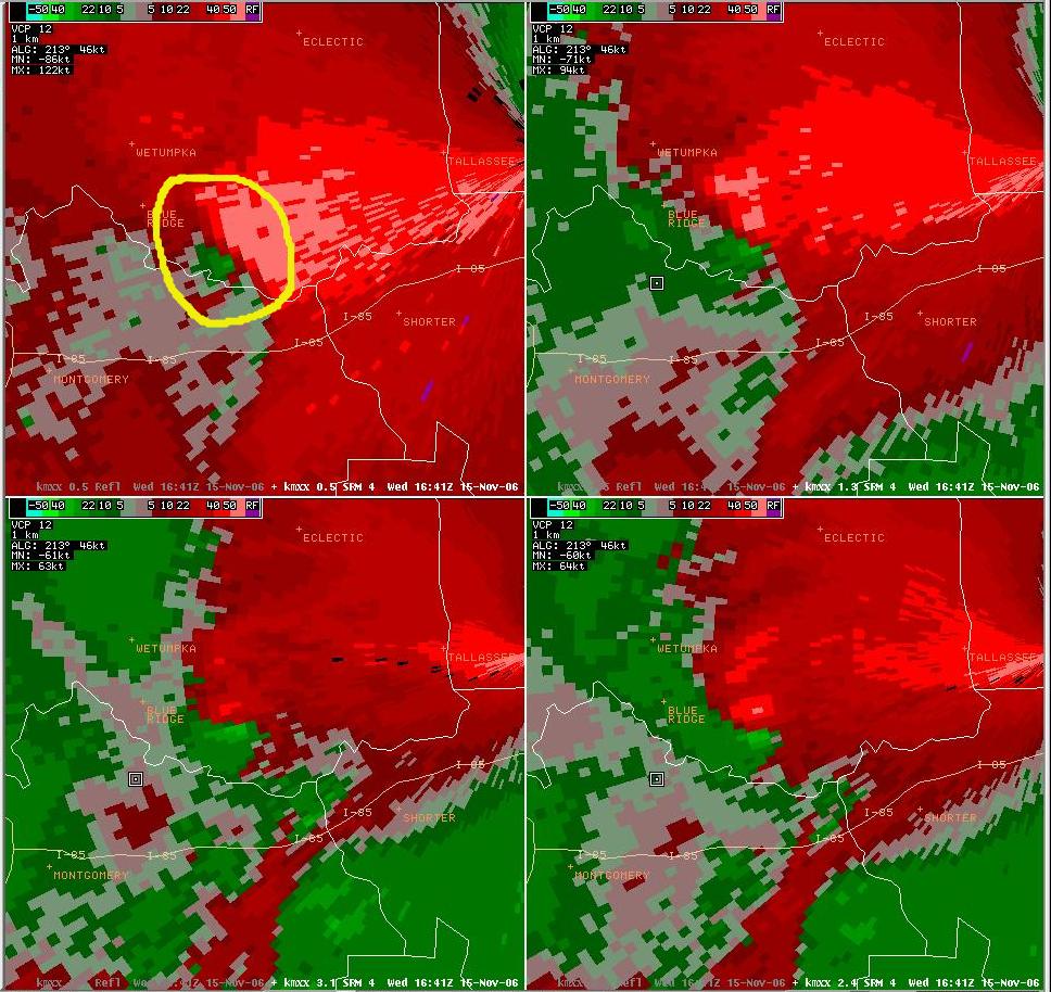
Southern Elmore County F1 Tornado - November 15, 2006
The tornado was on the ground from approximately 1040 AM CST (1640Z) until 1042 AM CST (1642Z).
|
Storm Relative Velocity Image taken from the Maxwell WSR-88D when the tornado was on the ground. At this time, the tornado was located just north of County Road 4, in the Emerald Mountain Subdivision. The radar is located almost due east of the rotation. The green colors indicate reflectors moving toward the radar and red colors indicate reflectors moving away from the radar. The parent thunderstorm exhibited strong rotation through a few thousand feet. This is the third tornado produced by the same parent thunderstorm.
|
|||||||||
Current Hazards
National Outlooks
Tropical
Local Storm Reports
Public Information Statement
Graphical Hazardous Weather Outlook
Current Conditions
Regional Weather Roundup
Rivers and Lakes
Drought Monitor
Forecasts
Aviation Weather
Graphical Forecasts
Forecast Discussion
Air Quality
Fire Weather
Climate and Past Weather
Past Events
Storm Data
Tornado Database
Daily Rainfall Plots
Tropical Cyclone Reports
Monthly Climate
Annual Climate
Warnings and Other Products
Tornado Warnings
Severe Thunderstorm Warnings
Flash Flood Warnings
Winter Weather Warnings
Special Weather Statements
Non-Precipitation Warnings
Flood/River Flood Warnings
Productos en Español
Conciencia y Preparación
Previsión de 7 Días
Weather Safety
NOAA Weather Radio
Severe Weather Preparedness
Severe Safety Rules
Tornado Safety Rules
Severe Safety w/ ASL
Awareness Weeks
Severe Weather
Hurricane Preparedness
Summer Safety Campaign
Winter Weather
US Dept of Commerce
National Oceanic and Atmospheric Administration
National Weather Service
NWS Birmingham, Alabama
465 Weathervane Road
Calera, AL 35040
205-664-3010
Comments? Questions? Please Contact Us.