NWS Birmingham, Alabama
Weather Forecast Office
Dora Tornado...November 10, 2002
The Dora Tornado, the sixth tornado of the evening, began at 9:38 pm, when the tornado first touched down on the banks of the Mulberry Fork of the Black Warrior River southwest of Dora. The initial touchdown was in an area of open fields and woods and the first structural damage occurred as the tornado reached the southwest side of Dora. Trees were downed with a good deal of roof damage to homes as the tornado traveled through the middle of Dora. Traveling northeast the tornado damaged a number of structures in Dora, before ending fairly abruptly on the north side of town at 9:47 pm.
The total path length was 4.3 miles, with a width of 300 yards. No deaths or injuries were reported. This tornado was rated an F1.
Tornado Watch Number 748 was issued at 4:35 pm. A Tornado Warning was issued for Walker County at 9:15 pm.
Thumbnail images below link to full sized images. All photos were taken by National Weather Service personnel.
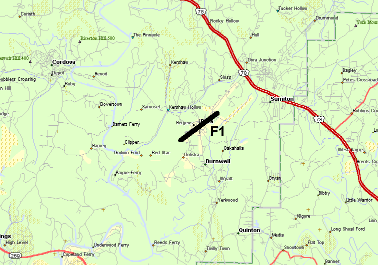 Map of the damage path. |
Current Hazards
National Outlooks
Tropical
Local Storm Reports
Public Information Statement
Graphical Hazardous Weather Outlook
Current Conditions
Regional Weather Roundup
Rivers and Lakes
Drought Monitor
Forecasts
Aviation Weather
Graphical Forecasts
Forecast Discussion
Air Quality
Fire Weather
Climate and Past Weather
Past Events
Storm Data
Tornado Database
Daily Rainfall Plots
Tropical Cyclone Reports
Warnings and Other Products
Tornado Warnings
Severe Thunderstorm Warnings
Flash Flood Warnings
Winter Weather Warnings
Special Weather Statements
Non-Precipitation Warnings
Flood/River Flood Warnings
Productos en Español
Conciencia y Preparación
Previsión de 7 Días
Weather Safety
NOAA Weather Radio
Severe Weather Preparedness
Severe Safety Rules
Tornado Safety Rules
Severe Safety w/ ASL
Awareness Weeks
Severe Weather
Hurricane Preparedness
Summer Safety Campaign
Winter Weather
US Dept of Commerce
National Oceanic and Atmospheric Administration
National Weather Service
NWS Birmingham, Alabama
465 Weathervane Road
Calera, AL 35040
205-664-3010
Comments? Questions? Please Contact Us.

