NWS Birmingham, Alabama
Weather Forecast Office
Winston County Tornado - September 16, 1996
A thunderstorm moved across northern Alabama on Monday morning traversing from eastern Mississippi over Lamar, Marion, and Winston counties before dissipating. During the lifespan of the thunderstorm, it produced at least two areas of wind damage - mainly trees and power lines downed - and what appeared to be two tornadoes.
The first tree damage occurred along County Road 35 about 4 miles north of Sulligent in northern Lamar County. There were conflicting reports of damage in southern Marion County, however, an aerial survey failed to reveal any damage. Additional wind damage occurred at Highway 5 south of Haleyville in extreme western Winston County. This area of damage appeared to be several trees down, all consistent with strong stright-line wind.
In northeastern Winston County, the thunderstorm apparently produced two weak tornadoes. The first began about a mile or so west of Moreland crossing through Moreland and destroying one chicken house and damaging several other buildings. The tornado path was about 100 yards wide and about two miles long. There was one spot in the forest where the tornado first touched down that damage to the trees was nearly total, thus the tornado was given a Fujita-scale ranking of F1.
The second tornado began about two miles southwest of the Upshaw community which is located about 5 miles north of Addison. This tornado was weaker than the first and was ranked an F0. Most of the damage was to trees and power lines though minor damage was reported to a couple of structures. The tornado path was four miles in length and about 80 yards wide.
There were no injuries in any of these weather events. All weather events occurred within weather warnings for the respective counties.
The information provided here was compiled by National Weather Service meteorologists conducting both ground and aerial surveys. Special thanks is extended to the Alabama State Troopers who provided the National Weather Service with a helicopter and pilot for the aerial survey.
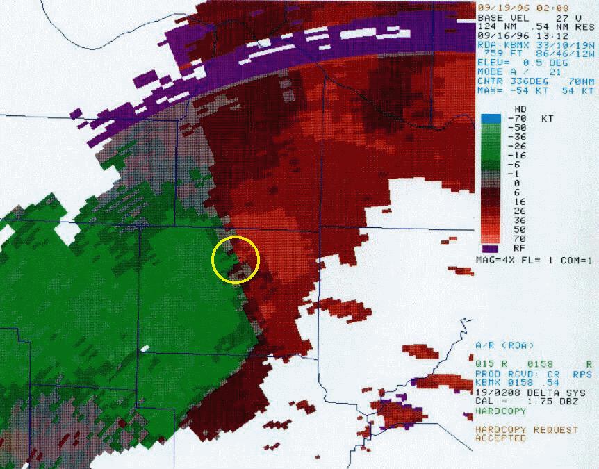
The pictures below show damage that occurred in the Moreland area. The two radar images were scanned hard copies of the storm that move across Winston county around the time of the tornado. The yellow circle on the storm relative velocity image shows the circulation associated with the storm.
To view a larger image, click on one of the pictures. File sizes are of the larger images.
 45kb jpg |
 49kb jpg |
 72kb jpg |
 Reflectivity 106kb jpg |
 Velocity 105kb jpg |
Current Hazards
National Outlooks
Tropical
Local Storm Reports
Public Information Statement
Graphical Hazardous Weather Outlook
Current Conditions
Regional Weather Roundup
Rivers and Lakes
Drought Monitor
Forecasts
Fire Weather
Aviation Weather
Graphical Forecasts
Forecast Discussion
Air Quality
Climate and Past Weather
Past Events
Storm Data
Tornado Database
Daily Rainfall Plots
Tropical Cyclone Reports
Warnings and Other Products
Tornado Warnings
Severe Thunderstorm Warnings
Flash Flood Warnings
Winter Weather Warnings
Special Weather Statements
Non-Precipitation Warnings
Flood/River Flood Warnings
Productos en Español
Conciencia y Preparación
Previsión de 7 Días
Weather Safety
NOAA Weather Radio
Severe Weather Preparedness
Severe Safety Rules
Tornado Safety Rules
Severe Safety w/ ASL
Awareness Weeks
Severe Weather
Hurricane Preparedness
Summer Safety Campaign
Winter Weather
US Dept of Commerce
National Oceanic and Atmospheric Administration
National Weather Service
NWS Birmingham, Alabama
465 Weathervane Road
Calera, AL 35040
205-664-3010
Comments? Questions? Please Contact Us.

