NWS Birmingham, Alabama
Weather Forecast Office
Sparks Creek (Hale County) EF-0 Tornado
September 5th, 2011
|
Rating:
(Click for EF Scale) |
EF-0
|
|
Estimated Maximum Wind:
|
70 MPH
|
|
Injuries/Fatalities:
|
None
|
|
Damage Path Length:
|
3.43 Miles
|
|
Maximum Path Width:
|
50 Yards
|
|
Approximate Start Point/Time:
|
32.7789/-87.4965 at 11:00 AM
|
|
Approximate End Point/Time:
|
32.8279/-87.4872 at 11:04 AM
|
NWS meteorologist have confirmed that an EF-0 tornado with estimated peak winds of 70 MPH touched down near Sparks Creek. The tornado touched down near the intersection of CR-32 and CR-51, about 8 miles northeast of Greensboro. The tornado then traveled on a north-northeast path for just under 3.5 miles, lifting just east of AL-25 on Starling Road. The tornado snapped off and uprooted several trees along its path. At least one tree landed on a house, damaging its roof. Another landed on and damaged a small hay storage barn. The metal roof panels of another outbuilding were torn off.
|
|||||||||
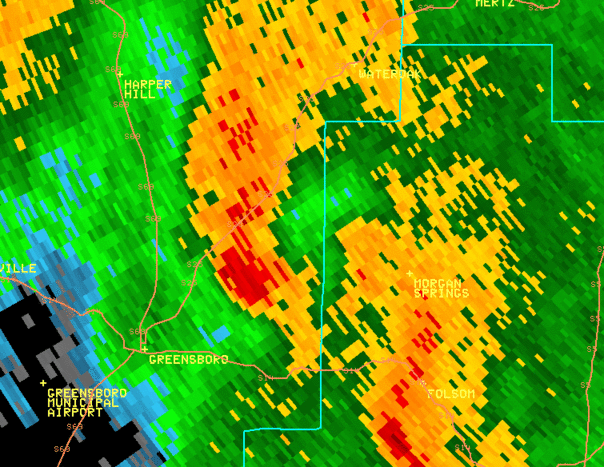
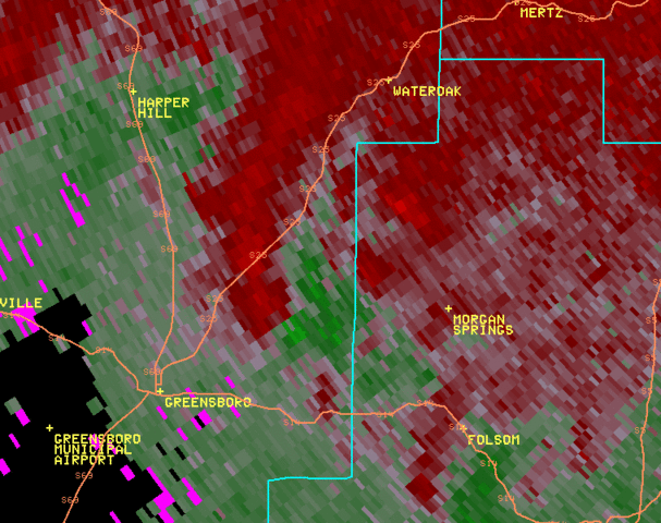
Radar Data
Below are loops of the reflectivity data (left) and storm relative velocity data (right) from the KBMX radar as the circulation passed north of Greensboro at 11:00 AM CDT. Click to enlarge the images.
Current Hazards
National Outlooks
Tropical
Local Storm Reports
Public Information Statement
Graphical Hazardous Weather Outlook
Current Conditions
Regional Weather Roundup
Rivers and Lakes
Drought Monitor
Forecasts
Air Quality
Fire Weather
Aviation Weather
Graphical Forecasts
Forecast Discussion
Climate and Past Weather
Past Events
Storm Data
Tornado Database
Daily Rainfall Plots
Tropical Cyclone Reports
Warnings and Other Products
Tornado Warnings
Severe Thunderstorm Warnings
Flash Flood Warnings
Winter Weather Warnings
Special Weather Statements
Non-Precipitation Warnings
Flood/River Flood Warnings
Productos en Español
Conciencia y Preparación
Previsión de 7 Días
Weather Safety
NOAA Weather Radio
Severe Weather Preparedness
Severe Safety Rules
Tornado Safety Rules
Severe Safety w/ ASL
Awareness Weeks
Severe Weather
Hurricane Preparedness
Summer Safety Campaign
Winter Weather
US Dept of Commerce
National Oceanic and Atmospheric Administration
National Weather Service
NWS Birmingham, Alabama
465 Weathervane Road
Calera, AL 35040
205-664-3010
Comments? Questions? Please Contact Us.