|
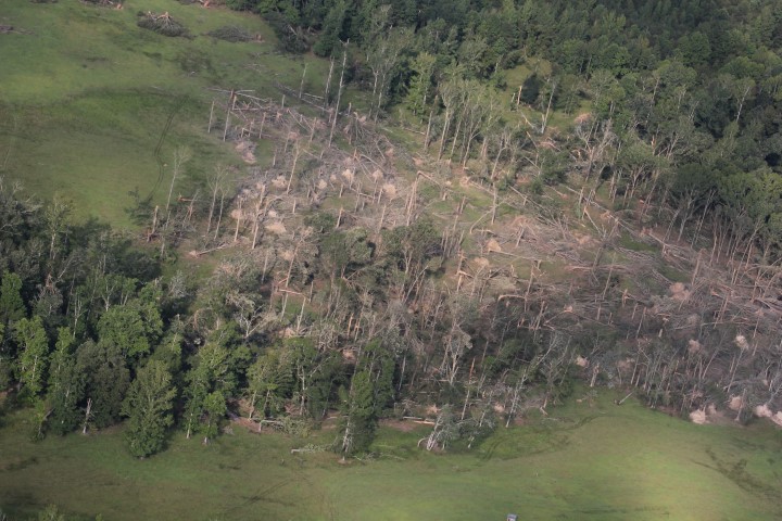
NWS meteorologists surveyed damage in northern Pickens County and found that the damage was consistent with an EF2 tornado. The tornado touched down at 7th Ave SW in the town of Reform. The tornado tracked northeast crossing Highway 82 and into residential areas where the worst damage occurred. Several single family wood framed homes and a mobile home were destroyed. One wood framed home was completely swept off its foundation. Several vehicles were also overturned. Four people, including an infant, were in the house that was swept off its foundation. They only suffered minor injuries. The tornado continued northeast and crossed near the intersection of County Road 25 and 15th Ave NW where numerous trees were snapped and uprooted. It then crossed Highway 17 about one mile south of County Road 8 where several trees were snapped and a house lost part of its roof. The tornado paralleled Highway 17 for several miles and did extensive tree and power line damage in the community of Palmetto. A fire station was also heavily damaged in Palmetto. From Palmetto, it traveled along County Road 59 where is snapped and uprooted trees, then it crossed through extreme southeast Lamar County and into southwest Fayette County at Jenkins Road. It continued northeast across the western portions of Fayette County, with numerous trees snapped and uprooted. Just before the tornado crossed Highway 96, it produced extensive tree damage at the Fayette Country Club Golf Course. It continued northeast crossing County Road 18 and Wilkinson Road, and then to County Road 85 near Earl Housh Road. It paralleled County Road 85 for several miles, producing tree damage. It finally lifted about one mile southwest of the intersection of Highway 43 and Housh Chapel Road.
|