NWS Birmingham, Alabama
Weather Forecast Office
August 2001 Floods
The remnants of Tropical Storm Barry moved across parts of Central and North Alabama on August 5th through the 6th. Although it did not produce very heavy rainfall across the area, Barry left a tropical air mass across the region in its wake. Showers and thunderstorms, over the next several days, produced locally heavy rainfall across parts of North and Central Alabama. The most noteable rainfall occurred on the morning of August 10th across parts of Madison, Marshall and Morgan counties in North Alabama.
Showers and thunderstorms developed around 3:00 am on the morning of August 10th across parts of south Madison County. The rain continued to develop and spread across parts of Marshall County and the east section of Morgan County. A radar animation from the Hytop radar shows showers and thunderstorms moving over parts of Madison County, then becoming more enhanced and widespread after 3:00 am. Although the rain was moving southeast, redevelopment was occurring over the same sections of these counties. This persistent heavy rainfall produced flooding of many roads and bridges. The runoff from the heavy rainfall caused soil erosion that downed trees and caused local creeks and streams to rise out of their banks.
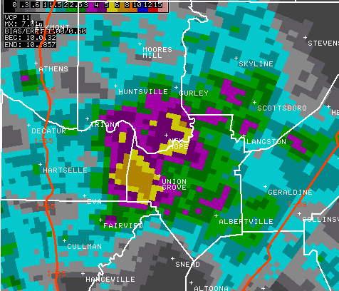
Radar rainfall estimates from the WSR-88D located at Shelby County Airport near Alabaster, Alabama (KBMX, shown above) showed mostly 3 to 5 inches across the area, with spots of 6 to 8 inches. Local observerations of rainfall amounts across this area ranged from 2 to 8 inches of rainfall. Areas such as New Hope, Owens Crossroads, Lacey Springs, Arab and Union Grove were the most impacted with rainfall amounts ranging from 4 to 8 inches.
Current Hazards
National Outlooks
Tropical
Local Storm Reports
Public Information Statement
Graphical Hazardous Weather Outlook
Current Conditions
Regional Weather Roundup
Rivers and Lakes
Drought Monitor
Forecasts
Fire Weather
Aviation Weather
Graphical Forecasts
Forecast Discussion
Air Quality
Climate and Past Weather
Past Events
Storm Data
Tornado Database
Daily Rainfall Plots
Tropical Cyclone Reports
Warnings and Other Products
Tornado Warnings
Severe Thunderstorm Warnings
Flash Flood Warnings
Winter Weather Warnings
Special Weather Statements
Non-Precipitation Warnings
Flood/River Flood Warnings
Productos en Español
Conciencia y Preparación
Previsión de 7 Días
Weather Safety
NOAA Weather Radio
Severe Weather Preparedness
Severe Safety Rules
Tornado Safety Rules
Severe Safety w/ ASL
Awareness Weeks
Severe Weather
Hurricane Preparedness
Summer Safety Campaign
Winter Weather
US Dept of Commerce
National Oceanic and Atmospheric Administration
National Weather Service
NWS Birmingham, Alabama
465 Weathervane Road
Calera, AL 35040
205-664-3010
Comments? Questions? Please Contact Us.

