National Weather Service United States Department of Commerce

Tornado Outbreak - April 24, 2010


Event Summary for Central Alabama - 8 Tornadoes Confirmed
Comprehensive Tornado Map

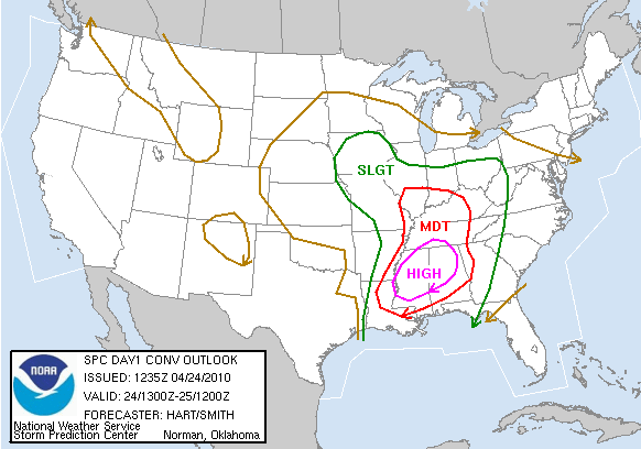
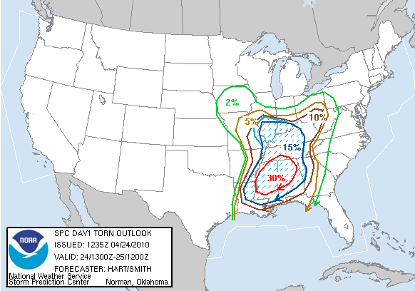
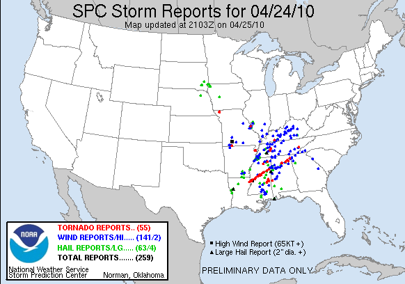
A very moist and unstable airmass  funneled out of the Gulf of Mexico and affected areas from Texas to Missouri to the Carolinas. The turning of the air flow with height, which is referred to as wind shear, was high enough for tornado development. A few strong short wave troughs were rotating around a large upper closed low and these features provided large scale lift to the area. The combination of the above factors set the stage for a tornado outbreak. The magnitude of the wind shear and moderate instability was enough for the Storm Prediction Center to advertise a High Risk of severe thunderstorms, including strong, long-lived tornadoes. Large hail, damaging winds, locally heavy rain and tornadoes formed and effected much of the southern United States April 23rd through April 25th.

Multiple supercell thunderstorms developed and tracked northeastward across Central Alabama. These storms began Saturday morning and continued through Saturday evening. Initially, eastern sections of the area received overnight and early morning rainfall which limited the instability. The severe potential slowly pushed eastward during the late afternoon and evening hours. Numerous damage reports were received throughout the event.

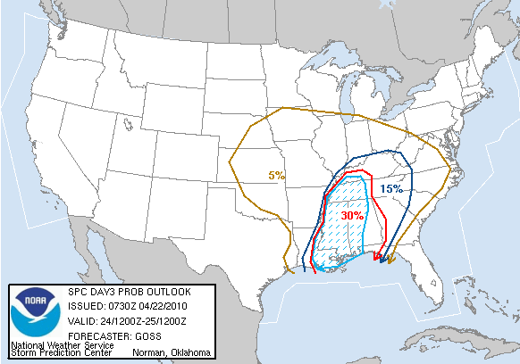
The potential weather threat was first introduced into the Hazardous Weather Outlook on April 18, 2010.  

Tornado Watch #93 was valid from 800am CDT until 200 pm CDT.
Tornado Watch #96 was valid from 120pm CDT until 900 pm CDT.
Tornado Watch #99 was valid from 715pm CDT until 200 am CDT.
Tornado Watch #101 was valid from 1045pm CDT until 600am CDT.

The survey information contained below is deemed preliminary. Additional evaluation is necessary and the information is subject to change.

Location/Clickable Detailed Summary Link
Damage Rating/Estimated Maximum Wind Speeds
Injuries/Fatalities
Damage Path Length/Width
Starting Point/Time
Ending Point/Time
EF-0
80 mph
None
7.22 miles
200 yards
33.9491/-87.8591
427 pm
34.0201/-87.7683
438 pm
EF-1
100 mph
None
6.60 miles
200 yards
33.6024/-87.6769
806 pm
33.6494/-87.5778
817 pm
EF-1
100 mph
None
4.60 miles
400 yards
33.6794/-87.5386
821 pm
33.7182/-87.4740
835 pm
EF-1 (Blount County portion)
100 mph
None
0.91 miles (Blount County portion)
200 yards
34.1917/-86.4146
959 pm
34.1950/-86.3991 (crossed into Marshall County)
1002 pm
EF-3
140 mph
None
29.5 miles
400 yards
33.7336/-87.2864
1001 pm
33.8532/-87.7931
1055 pm
EF-0
80 mph
None
5.84 miles
100 yards
32.7628/-87.5461
1150 pm
32.8335/-87.4912
1203 pm

EF-0
80 mph

None
0.1 miles
30 yards
32.3645/-88.2842 at 1044 am
32.3645/-88.2842 at 1044 am 

EF-1
95 mph

2 Injuries
9.3 miles
200 yards
32.5178/-87.8585 at 1119 am
32.6236/-87.7636 at 1135 am 


Preliminary Local Storm Reports
Public Information Statement

Additional Storm Assessments:

NWS Huntsville, AL
NWS Jackson, MS
NWS Morristown, TN


Severe Weather Episode Data


Surface Analysis 4/24 7 am
Surface Analysis
Apr. 24th 6 am
500 mb Chart 4/24 7 am
500 mb Chart
Apr. 24th 6 am
Day 3 Severe Weather Outlook
Issued Apr. 22nd
Day 3 Severe Weather Probabilistic
Day 3 Probabilistic Outlook
Issued Apr. 22nd
Day 2 Severe Weather Outlook
Issued Apr. 23rd
Day 2 Severe Weather Probabilistic
Day 2 Probabilistic Outlook
Issued Apr. 23rd
Day 1 Severe Weather Outlook
Issued Apr. 24th
Day 1 Severe Weather Probabilistic
Day 1 ProbabilisticOutlook
Issued Apr. 24th
Severe Weather Reports
Apr.23rd
Severe Weather Reports
Apr.24th
Rainfall Plots
Rainfall Plots 23rd-24th
Rainfall Plot
Rainfall Plots 24th-25th
raob
25/00z BMX Raob
Courtesy of University of Wyoming