National Weather Service United States Department of Commerce

Shopton Tornado - Bullock County
April 19, 2009


EF-0
Estimated Maximum Wind:
60-70 mph
Injuries/Fatalities:
None
Damage Path Length:
0.10 miles
Maximum Path Width:
50 yards
Approximate Start Point/Time:
32.1617/-85.9345
at 836 pm
Approximate End Point/Time:
32.1621/-85.9335
at 836 pm

A National Weather Service Damage Assessment Team has surveyed the storm damage in Bullock County. It has been determined the damage was the result of a tornado. The tornado has been rated an EF-0 on the Enhanced Fujita Scale. Damage estimates were consistent with winds around 60-70 mph.

A tornado touched down 2 miles north of the town of Shopton. Damage included numerous trees snapped and uprooted. The length of the path was 0.10 miles and was 50 yards wide.


Radar


Radar
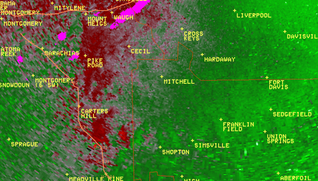
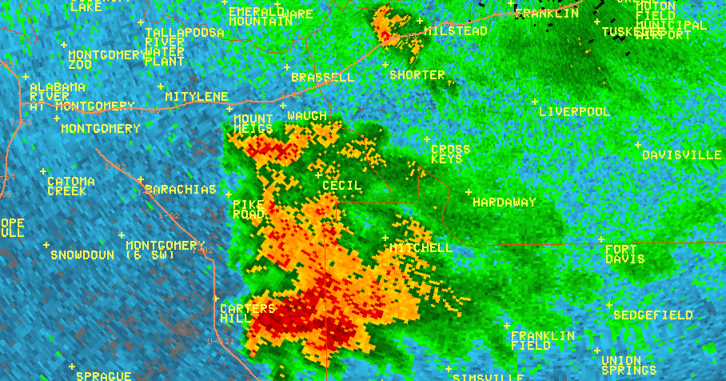
The top image is a KMXX 0.5 degree reflectivity loop. The bottom image is a KMXX 0.5 degree storm relative velocity loop. The green indicates wind blowing toward the radar while red indicates wind blowing away from the radar. This storm exhibited gate-to-gate rotation and a pronounced hook echo at times. Also notice, beginning in the third frame in the reflectivity, there is also a very evident Rear Flank Downdraft (RFD) on the southwest corner of the storm, which is indicative of a mature supercell thunderstorm.