|
Event Summary
|
|
EF-1
|
|
Estimated Maximum Wind:
|
95 mph
|
|
Injuries/Fatalities:
|
None |
|
Damage Path Length:
|
3.76 miles
|
|
Maximum Path Width:
|
95 yards
|
|
Approximate Start Point/Time:
|
1 NNE Glencoe
33.9768/-85.9276
at 628 am
|
|
Approximate End Point/Time:
|
1.5 NNE Hokes Bluff
34.0087/-85.8753
at 633 am
|
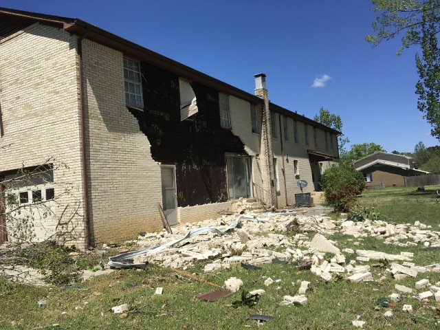
National Weather Service meteorologists surveyed the damage in southeastern Etowah County and determined it was the result of a tornado with maximum sustained winds of 95 mph.
This tornado began near Taylor Road where a large tree was uprooted and light trim damage was done to a house. Damage intensity rapidly increased as the tornado crossed Rabbittown Road. One residence had significant damage done to its roof and an exterior wall, along with broken windows. A car was also picked up/shifted. A second residence, which appeared to have very little/no anchoring, was greatly shifted from its foundation with heavy roof damage and broken windows. Across the street, a third residence had significant roof and wall damage, along with broken windows. The pattern of fallen trees in this vicinity indicated a cyclonic wind pattern, helping to confirm tornadic winds despite the storm`s presentation on radar.
The tornado continued northeastward, knocking down additional trees as it neared and crossed Highway 278. Several outbuildings were destroyed and tossed downwind at a residence located along Tidmore Bend Road. The tornado then crossed the Coosa River and caused light roof damage to a dock as well as knocked down some trees before dissipating just before Alford Bend Road.
|