Storm Data
| Note: That this is only a partial record.
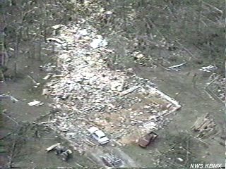
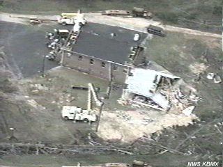
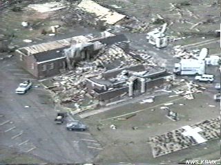
In trying to unravel the events of the day after the fact, there is a great deal of confusion and uncertainty about the times of many events. This stems from the fact that these waves of severe weather moved over many of the same counties three or four times. Every attempt has been made to get this information as correct as possible. It is also possible that some smaller events may not have been reported since there was so much attention drawn to the three major tornado events in Dekalb, St. Clair, Calhoun, Cherokee, and Shelby counties. St. Clair, Calhoun, Cherokee Counties - Tornado (F4) A tornado began about 1 mile south-southwest of Ragland in St. Clair County at to 5 miles northeast of Rock Run 10:55 am CST. It traveled northeast at between 45 and 55 miles an hour crossing the Alabama/ Georgia border about 5 miles northeast of Rock Run in Cherokee County. The tornado moved across County Highway 144 just south-southwest of Ragland where it first began then destroyed a number of structures along 144 to the east of Ragland. The tornado crossed primarily wooded land before moving through a camping area on the west side of Neely Henry Lake. A woman was killed outside on the west side of the lake as she tried to secure a boat. The tornado crossed Neely Henry Lake just north of the dam as it moved into Calhoun County. Twenty-six homes were damaged, 18 homes were destroyed, and 20 mobile homes were destroyed in St. Clair County. Moving into Calhoun County at 11:04 am CST, the storm continued on a steady northeast track (60 degree heading) crossing the north side of Ohatchee. The storm crossed US Highway 431 at 11:20 am where one man was killed when the van he was in was thrown into a ditch. Three other people in the van were injured. The storm continued northeast across mostly woodlands with only scattered structures, mostly homes, in its path. It crossed US Highway 278 between four and five miles west-northwest of Piedmont. The storm entered Cherokee County at 11:35 am CST. At 11:39 am CST the tornado destroyed the Goshen United Methodist Church located 1 mile north of the Cherokee/Calhoun County line on County Highway 9 killing 20 people and injuring 92. The tornado continued northeast across Cherokee County reaching the Alabama/ Georgia state line at approximately 11:52 am CST. Marshall County - Tornado (F2) A tornado travelled southwest to northeast across an area just south of the city of Guntersville. The tornado apparently began along Highway 79 South then cross Big Spring Creek damaging a number of residential structures along Spring Creek Drive. The tornado appeared to weaken but was still strong enough to rip off the top part of the roof to the Marshall Nursing Home and damaging several houses near the entrance to Happy Home. It crossed U. S. Highway 431 near the high school taking out some trees on the side of the mountain and damaging a couple of homes. A total of 103 houses were damaged, 45 of them along Spring Creek Drive and 8 along Highway 79 South. In addition, hail of 0.75 near Arab at 1055 am CST, and 1.75 inches in diameter reported at Guntersville at 1115 am CST. Dekalb County - Tornado (F3) A tornado struck near the Grove Oak area in the western sections of Dekalb County moving northeast through the towns of Rainsville, Sylvania, and Henager. In the path of the tornado, Emergency Management personnel reported 16 homes and 13 mobile homes completely destroyed, 45 homes and 2 mobile homes with major damage, and 21 homes and 9 mobile home with minor damage. Two businesses and 12 poultry houses were destroyed. In addition, 0.75 inch hail reported at Sylvania at 1148 am CST, at Henager at 1157 am CST. At 1150 am CST golf ball size hail was reported in southern Cherokee County, 10 miles southeast of Centre, with the thunderstorm that produced the tornado. Blount County - Tornado (F0) At 1157 am CST, a tornado was reported in the Sugar Creek Community about 3 miles southwest of Nectar along Alabama 160. The storm damaged six homes, downed power lines and trees, and destroyed three greenhouses and damaged a fourth. Pickens County - Thunderstorm winds At 300 pm CST, a thunderstorm produced wind damage in the Carrollton-Gordo area as well as in the Reform area. Damage was light in the Reform area with a number of trees down, several blocking roads and several falling on other buildings. In the area from Carrollton to Gordo, many trees were downed and a number of structures sustained minor damage. A house near Aliceville reportedly suffered major damage. Winston and Walker Counties - Flooding 345 pm CST to Midnight - Heavy rains from a combination of thunderstorms early in the day and continuous moderate rain with embedded heavy rains in the afternoon and evening contributed to widespread flooding across the three counties. A considerable number of county roads were closed due to high water as well as several roads in Jasper. In Winfield in Marion County one of the area's oldest bridges collapsed due to the high water. Blackwater Creek was well out of its banks near Alabama Highway 5 with heavy flooding along Alabama 124, both in Walker County. In Winston County, $150,000 damage was done to roads and bridges. Bridges on Brown's Creek and Splunge Creek were underwater and a number of county roads including 339, 67-F, and 22-W sustained damage. Tuscaloosa County - Wind damage and hail From 350 pm to 405 pm CST there were numerous weather events were reported with a thunderstorm moving across Tuscaloosa County. Hail ranged from one to one and three quarters of an inch in the Coker, Eagle Cove, and Morrisbridge areas. Funnel Cloud sighted near Lake Tuscaloosa. Tuscaloosa County - Tornado (F1) Around 402 pm CST a tornado struck in an unpopulated area of Tuscaloosa County about 15 miles northeast of the center of Tuscaloosa. A 115 kilovolt power transmission line operated by Alabama Power Company was broken when two power structures were downed; a third was leaning. Jefferson County from 423 to 451 pm CST - Damaging wind and hail
Greene County - Wind damage 447 pm CST - Wind with a thunderstorm gusted to over 55 miles an hour destroying one mobile home and pushing a second one off it's foundation in northern Greene County southwest of Jena. Calhoun County - Wind damage and hail Ohatchee at 1730 CST hail 1.75" or golf ball size hail was reported at Ohatchee with numerous trees down on Highway 204 near U. S. Highway 431. Shelby County 531 pm to 545 pm CST - Tornado (F2) A tornado began on the north side of Helena on the Bearden Farm moving northeastward crossing Alabama 261 near Pelham High School. The school suffered some damage. Continuing northeast, the tornado caused damage in a residential section before doing extensive damage to two mobile home parks on the west side of U. S. Highway 31 on the north side of Pelham. The tornado did extensive to businesses in the stretch from the U. S. 31/Alabama 119 intersection to the Alabama 119/Interstate 65 intersection. The tornado continued on its track going through primarily residential areas of Pelham and Indian Springs. The tornado dissipated just before reaching the Meadow Brook area about two miles west of U. S. Highway 280. Areas in the path of the tornado included sections of Chandalar, Green Park South mobile home park, South Gate Mobile Home Park, Indian Springs Village, Broken Bow, Broken Bow South, and Riverchase. Blount County - Wind damage At 535 pm CST near Oneonta - Wind with a thunderstorm downed trees in the southwestern sections of Blount County in the same area affected by a storm earlier in the day. Cherokee County - Funnel Cloud At 550 pm CST, Goshen, At the destroyed church site of the tornado earlier that morning, rescue workers and emergency personnel sought shelter when a funnel cloud was observed. Cleburne County - Wind damage and hail At 720 pm CST - Hail slightly larger than golf ball size was reported at Heflin. A number of trees were downed by wind. Damage in Heflin began on U. S. Highway 78 West and crossed through town. Southeastern United States Palm Sunday Tornado Outbreak of March 27, 1994 via the Office of Meteorology Homepage.
|