National Weather Service United States Department of Commerce


Tornadoes of March 30, 2022

Overview
 

The NWS Birmingham service area was mostly spared from severe weather on Friday, March 24th, 2023. A majority of severe storms occurred along an axis from central Mississippi to northern Alabama to the southern Appalachians. The most significant storm of this day tracked from the Mississippi River at Rolling Fork to northern Alabama. The storm produced multiple tornadoes, including a deadly EF-4 and two EF-3s in Mississippi. The storm morphed as it crossed into Alabama, producing multiple areas of straight-line wind damage in Marion County and Winston County as well as an EF-1 tornado at Bear Creek (in the NWS Birmingham service area). The storm complex continued to produce additional straight-line wind damage and tornadoes in north Alabama.

Things then became much more active across central Alabama. The front associated with this weather system stalled along the Gulf Coast through the weekend. Plenty of deep-layer shear was in place along the front thanks to low-amplitude troughing aloft. A dry air mass was in place north of the front with warm, moist, unstable air along and south of the front. Multiple waves of severe storms occurred from the early morning hours on Sunday, March 26th, 2023 to the early morning hours on Monday, March 27th, 2023, tracking in the vicinity of the stalled front. These storms produced large, damaging hail as large as baseballs, damaging straight-line winds, a few tornadoes, and flooding that washed out some roadways.


View Larger Map

 
Surveys
 

**The data below are considered PRELIMINARY.**

 
Location/Date
Damage Rating/Estimated Maximum Wind Speeds
Injuries/Fatalities
Damage Path Length/Width
Starting Point/Time
Ending Point/Time

Bear Creek Tornado
(Marion County)

Friday, March 24th

EF-1
110 mph
None 5.19 miles
275 yards
2 NNE Tessner
34.2781/-87.7661
11:44 pm CDT
3 NE Bear Creek
34.2871/-87.6766
11:49 pm CDT

Flatwood Tornado
(Marengo County)

Sunday, March 26th

EF-1
90 mph

 
None 4.35 miles
750 yards
4 NNW Lamison
32.1824/-87.5952
8:33 pm CDT
1 N Flatwood
32.1697/-87.5225
8:38 pm CDT

Prattville Pickers Tornado
(Autauga County)

Sunday, March 26th

EF-0
75 mph
None 1.03 miles
200 yards
1 NE Autauga County Airport
32.4481/-86.4921
9:39 pm CDT
2 WSW Prattville
32.4556/-86.4778
9:41 pm CDT

Lake Martin Tornado
(Elmore and Tallapoosa Counties)

Sunday, March 26th

EF-1
110 mph
None 7.46 miles
1200 yards
2 S Martin Lake at Kowaliga
32.7106/-85.9690
10:22 pm CDT
2 SSW Still Waters Resort
32.7193/-85.8414
10:29 pm CDT

Milstead Tornado
(Macon County)

Monday, March 27th

EF-2
125 mph
None 15.41 miles
1450 yards
1 NW Tysonville
32.4103/-86.0079
2:41 am CDT
3 ENE Franklin
32.4744/-85.7564
3:06 am CDT
 
Bear Creek EF-1
 

Bear Creek EF-1 Tornado (Marion County)
  March 24, 2023


Event Summary

EF-1
Estimated Maximum Wind:
110 mph
Injuries/Fatalities:
None
Damage Path Length:
5.19 miles
Maximum Path Width:
275 yards
Approximate Start Point/Time:
2 NNE Tessner
34.2781/-87.7661
11:44 pm CDT
Approximate End Point/Time:
3 NE Bear Creek
34.2871/-87.6766
11:49 pm CDT


NWS meteorologists found damage consistent with a tornado. The tornado began along the Horseshoe Bend area of Bear Creek. The tornado moved eastward where it produced its most significant damage along Highway 172 and Highway 241 where numerous pine trees were snapped. Additional trees were downed as the tornado
approached Highway 13 where it also caused damage to a house and barn on County Road 65. The tornado dissipated along the banks of the Upper Bear Creek Reservoir.

Upon further investigation of aerial imagery during the following days, the starting point of the tornado was moved around a mile west of previously estimated. The tornado path was observed to have crossed Bear Creek no less than six times before reaching Highway 172. Numerous trees were uprooted along the first mile of the path, up to low-end EF-1 intensity.

Tornado Track Map


Radar Image
Reflectivity (left) and velocity (right).
Images are from KGWX at 11:47 pm CDT.


Damage Photo
 Pine trees snapped.
Damage Photo
 Barn destroyed.
 
Flatwood EF-1
 

Flatwood EF-1 Tornado (Marengo County)
  March 26, 2023


Event Summary

EF-2
Estimated Maximum Wind:
120 mph
Injuries/Fatalities:
None
Damage Path Length:
4.35 miles
Maximum Path Width:
750 yards
Approximate Start Point/Time:
4 NNW Lamison
32.1824/-87.5952
8:33 pm CDT
Approximate End Point/Time:
1 N Flatwood
32.1697/-87.5225
8:38 pm CDT


A tornado developed over an inaccessible area west of County Road 53 and moved along an east-southeast path.
Numerous pine trees were snapped or uprooted along the road, with a metal property gate being crushed. From there, the tornado moved across County Road 14, where several more pine trees were knocked down and another gate was damaged ​before the tornado crossed into Wilcox County. NWS Birmingham would like to thank NWS Mobile for assisting with this survey.

Tornado Track Map


Radar Image
Reflectivity (left) and velocity (right).
Images are from KBMX at 8:34 pm CDT.
 
Damage Photo
 Pine trees snapped.
Damage Photo
 Pine trees downed onto field gate.
 
Prattville Pickers Tornado EF-0
 

Prattville Pickers EF-0 Tornado (Autauga County)
  March 26, 2023


Event Summary

EF-0
Estimated Maximum Wind:
75 mph
Injuries/Fatalities:
None
Damage Path Length:
1.03 miles
Maximum Path Width:
200 yards
Approximate Start Point/Time:
1 NE Autauga County Airport
32.4481/-86.4921
9:39 pm CDT
Approximate End Point/Time:
2 WSW Prattville
32.4556/-86.4778
9:41 pm CDT


A brief EF-0 tornado formed over Prattville Country Club where tree limbs were blown down. The tornado crossed Highway 82 where a few trees were knocked down, metal panels were blown off a business, and power poles and lines were downed by fallen trees. The tornado then moved across a neighborhood where additional trees and limbs were blown down, before dissipating near Deerwood Drive.


Tornado Track Map


Radar Image
Reflectivity (left) and velocity (right).
Images are from KBMX at 8:39 pm CDT.
 
Damage Photo
 Prattville Pickers damaged.
Damage Photo
 Trees downed on Deer Run Drive.
 
Lake Martin EF-1
 

Lake Martin EF-1 Tornado (Elmore & Tallapoosa Counties)
  March 26, 2023


Event Summary

EF-1
Estimated Maximum Wind:
110 mph
Injuries/Fatalities:
None
Damage Path Length:
7.46 miles
Maximum Path Width:
1200 yards
Approximate Start Point/Time:
2 S Martin Lake at Kowaliga
32.7106/-85.9690
10:22 pm CDT
Approximate End Point/Time:
2 SSW Still Waters Resort
32.7193/-85.8414
10:29 pm CDT


This tornado began in a wooded area just west of Tecumseh Point Road in Elmore County. Along the road, tree damage was immediately significant along a fairly wide path, earning an EF-1 rating. From here, the tornado crossed the water into the Castaway Island area, where numerous pine trees were knocked down, with some falling on power lines and homes. The only visible damage to any structures here appeared to have been caused by falling trees. From there, the tornado moved back over the water and into The Ridge neighborhood. Here, three to four homes right along the lakeshore on Sundown Ridge and Dawson Point sustained considerable roof and siding damage, and many surrounding trees were blown down, earning a higher EF-1 rating. A couple of roughly 130-foot tall concrete electric transmission poles were downed south of the main path at the end of Dawson Point, with the lines falling into the lake. Immediately east, more trees were downed along South Ridge, although surrounding homes seemed to have no damage. The tornado then crossed an inaccessible island before moving into Tallapoosa County, where the damage was much weaker and more sporadic. A few trees were uprooted along Long Branch Drive and Old Tree Road, but mainly along ridge tops. Roads at lower elevations along the lakeshore had little in the way of tree damage. A few more small trees and limbs were downed along Center Point Road before the tornado dissipated.

Tornado Track Map


Radar Image
Reflectivity (left) and velocity (right).
Images are from KBMX at 10:23 pm CDT.
 
Damage Photo
 Home with roof damage.
Damage Photo
 Trees downed.
 
Milstead EF-2
 

Milstead EF-2 Tornado (Macon County)
  March 27, 2023


Event Summary

EF-2
Estimated Maximum Wind:
125 mph
Injuries/Fatalities:
None
Damage Path Length:
15.41 miles
Maximum Path Width:
1450 yards
Approximate Start Point/Time:
1 NW Tysonville
32.4103/-86.0079
2:41 am CDT
Approximate End Point/Time:
3 ENE Franklin
32.4744/-85.7564
3:06 am CDT


National Weather Service meteorologists performed a damage survey for the area near Milstead in Macon County, confirming an EF-2 tornado with maximum winds of 125 mph. The tornado began in the area of Tysonville Road, with only sporadic tree limbs and small trees blown down. Damage became more concentrated along County Road 138, where the attached carport of a house was ripped away and destroyed. Numerous trees, mostly pine trees, were damaged along a path of several hundred yards. On County Road 40, the damage became more intense, with dozens of trees down, some falling on power lines. The top of a silo was blown off, with roofing material scattered southward, before the tornado reached the cotton gin in Milstead. Here, the main structure sustained significant damage, with failure of the roofing system and outer walls of the structure, earning the EF-2 rating. Most of the inner walls remained standing, and two large buildings adjacent to the main structure only sustained comparatively minor roof and siding damage. Just east of the structures, significant tree damage was observed around a small lake, consistent with an EF-2 rating. Along the road and railroad immediately south of the cotton gin, numerous concrete power poles were pulled down in a northward direction across the railroad tracks, and a pivot irrigation system was flipped in a large field.

Continuing eastward, the Auburn University E.V. Smith Research Center sustained damage to several buildings on the property, with one farm shed partially collapsing and roofing material being blown northward across the road. Widespread tree damage continued along County Road 9 for around three miles, although most of the trees that were downed were pine trees. There was also occasional minor damage to roofing on homes, mostly caused by trees. The damage through here was consistent with upper-end EF-0 or low-end EF-1. Damage became much more sporadic as the tornado passed through the Franklin community, with only a few trees uprooted or trees knocked down. There was a slight uptick of more concentrated tree damage on the east side of County Road 27 before the tornado dissipated.


Tornado Track Map


Radar Image
Reflectivity (left) and velocity (right).
Images are from KEOX at 2:49 am CDT.


Damage Photo
 Metal building collapsed.
Damage Photo
 Tree damage.
 
Large, Damaging Hail
 

 Large Hail up to Baseball Size (Many central Alabama Counties)


Large, damaging hail was very prevalent with multiple waves of storms from the early morning hours of Sunday, March 26th (prior to sunrise) through Sunday evening. Windows of vehicles were busted in Camp Hill, AL and Verbena, AL, perhaps in a few other communities as well. The largest hail reported during the waves of severe storms was baseball size (2.75"). A few communities had more than one round of large hail. In central Alabama, these hail storms mainly occurred along a southwest to northeast axis from Sumter County, AL to Chambers County, AL. Severe hail also occurred upstream in Mississippi and downstream in Georgia.


Triangle icons represent where significant hail (2" or larger) was reported with a wave of severe storms during the early-morning hours on Sunday, March 26th. Hail as large as baseball size (2.75") was reported in Cooper (Chilton County), Lafayette (Chambers County), and Camp Hill (Tallapoosa County).


Triangle icons represent where significant hail (2" or larger) was reported with a wave of severe storms during the afternoon and evening hours on Sunday, March 26th. Hail reached 2" in diameter in Jefferson (Marengo County), Cuba (Sumter County), and Reeltown (Tallapoosa County).


All severe hail reports (1" / quarter size or larger) are shown, accounting for the multiple waves of severe storms early Sunday morning into Sunday night). Circle icons show hail between 1" and 2". Triangle icons show hail larger than 2".


Damage Photo
 Car windows busted by large hail in
Camp Hill, AL. Photo: Twitter @E_VZ
Damage Photo
 Golf ball size hail south of
Alexander City, AL. Photo: Twitter @AUTiger1966

Damage Photo

Car windows busted by large hail in Camp Hill, AL.
Photo: Robin Landrum

Damage Photo

Large hail in Camp Hill, AL.
Photo: Dixie Henderson


Damage Photo

Large hail in Verbena, AL.
Photo: Brandi Patterson

Damage Photo

Large hail in Thorsby, AL.
Photo: Derek Price and Nancy Huett

Damage Photo

Large hail in Marbury, AL.
Photo: Susan Cowen

Damage Photo

Large hail at Lake Martin, AL.
Photo: Terri Phipps

 
Damaging, Straight-line Winds
 

 Trees Downed and Structures Damaged (Autauga and Elmore Counties)


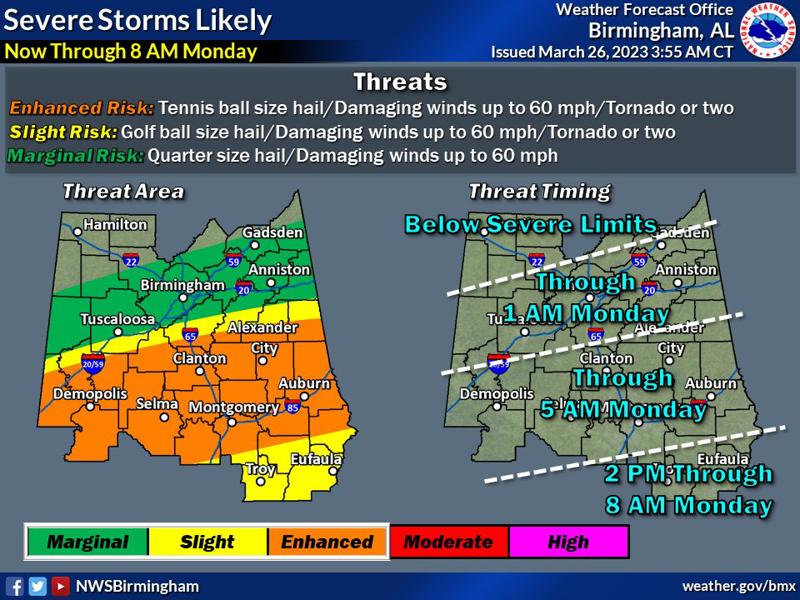
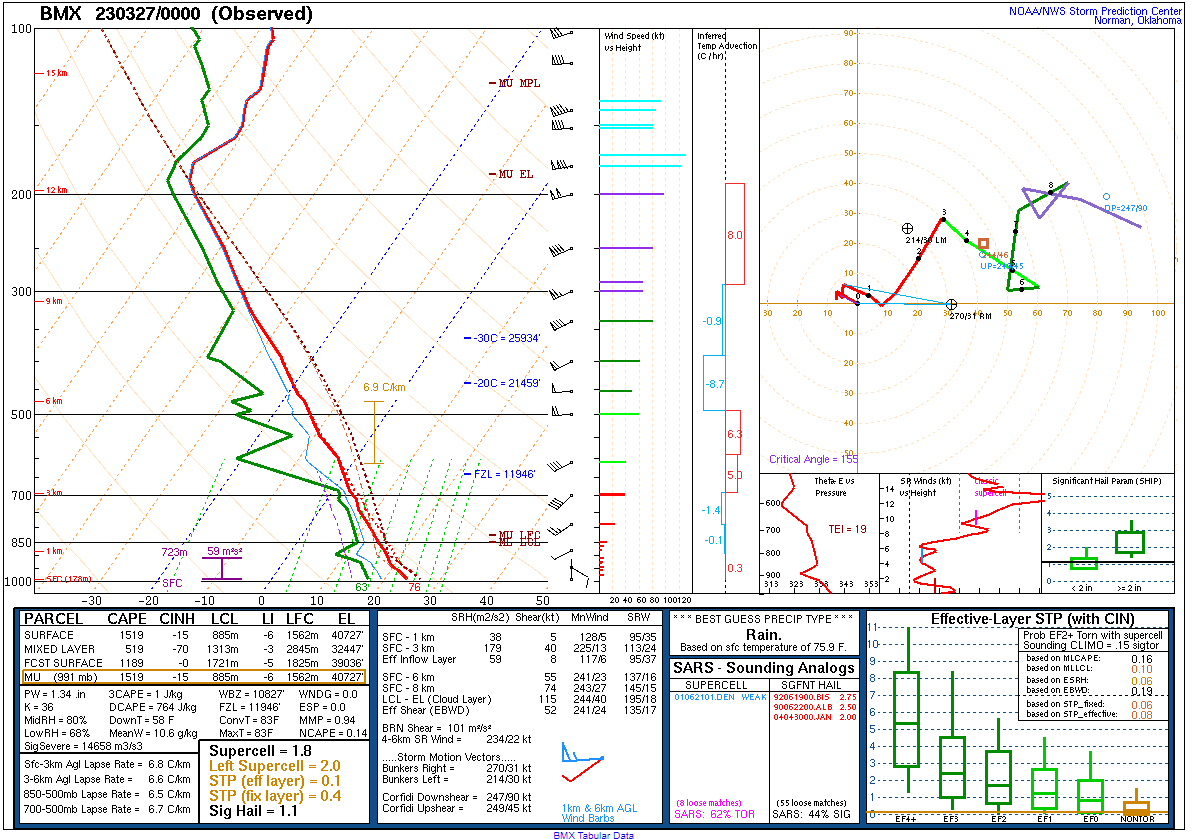
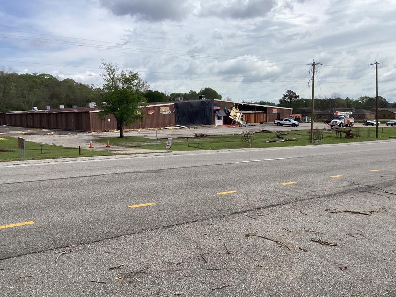
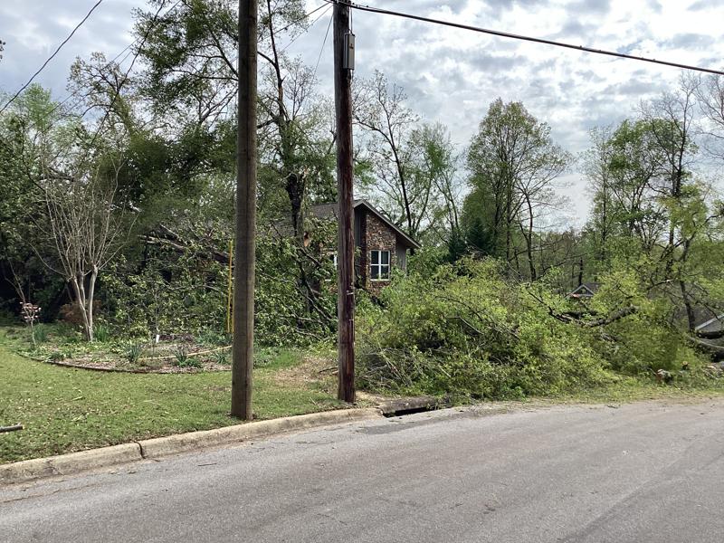
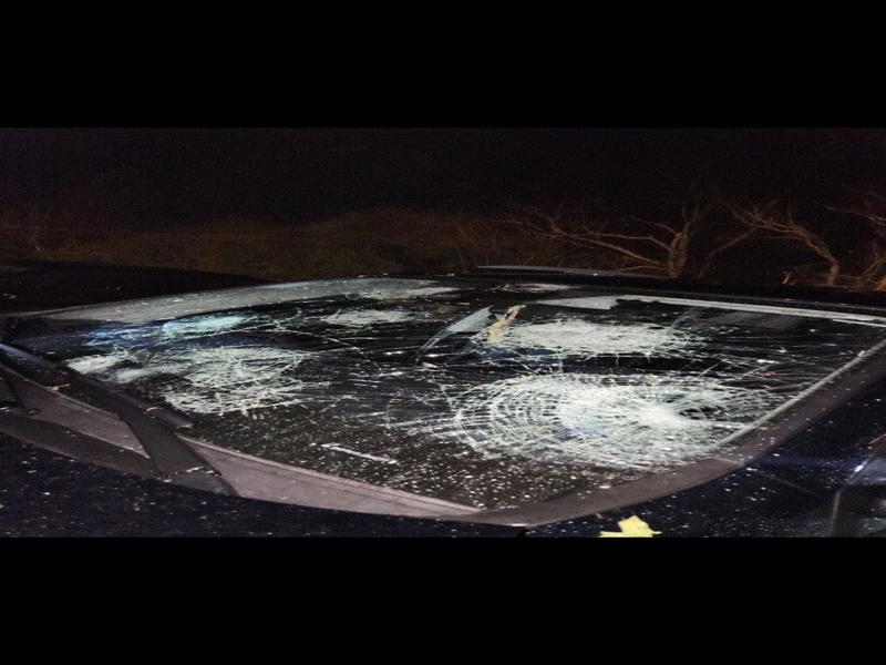
Storms during this event also produced straight-line winds that took down trees and caused structural damage (either directly cause by wind or by fallen trees). Two areas of notable damage, based on received reports, were surveyed by NWS Birmingham. The two areas included the County Road 39 and Ross Road area along the Autauga County/Elmore county line and the Airport Road area of western Elmore County.


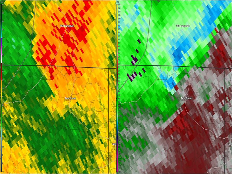
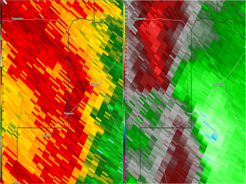
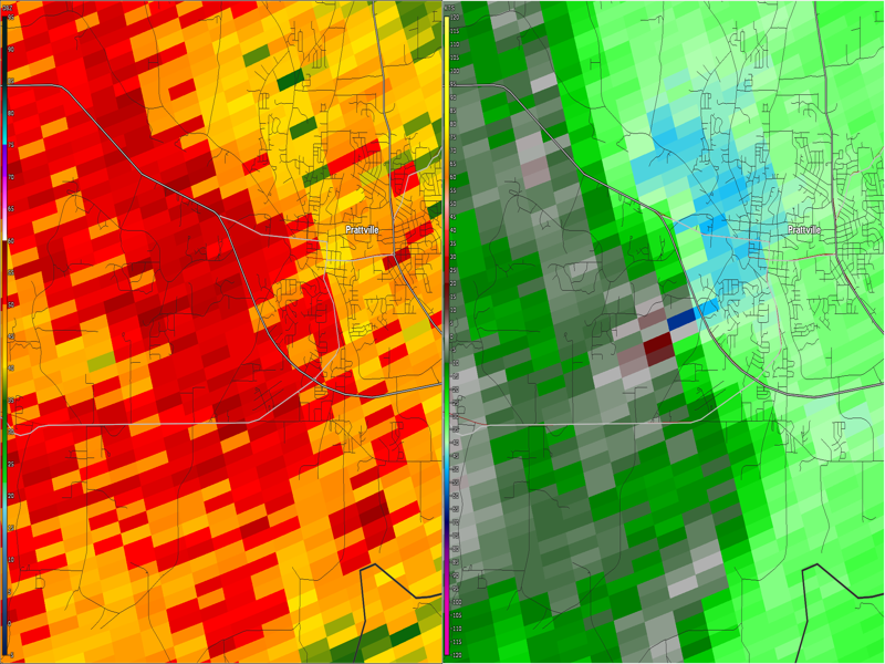
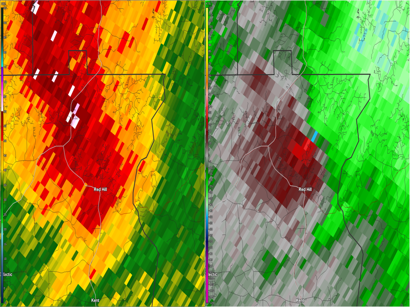
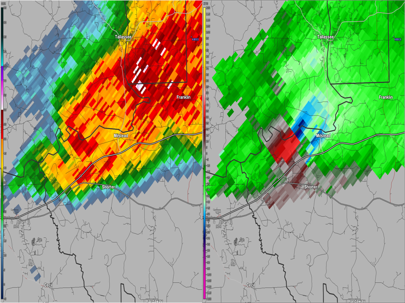
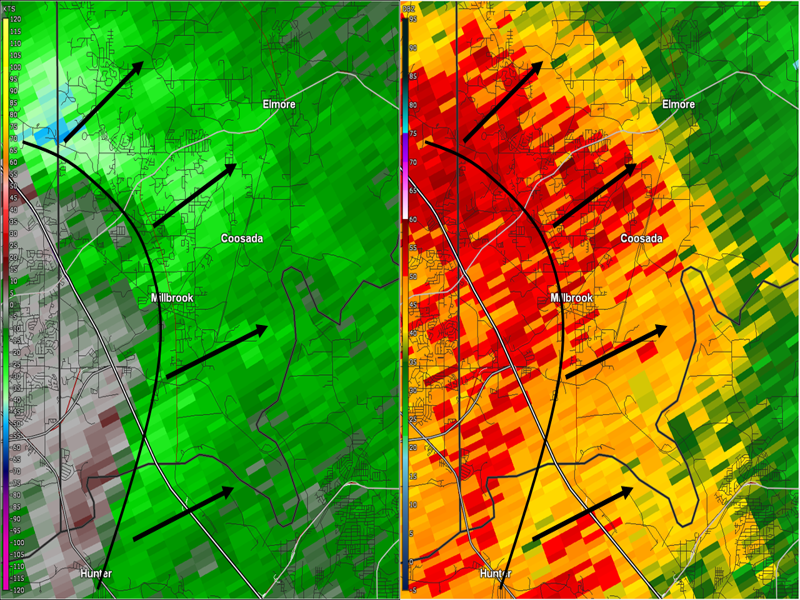
The below radar image shows the storm as it moved across eastern Autauga County and western Elmore County. The arched black line shows the location of a bowing segment within the storm, which is the feature that produced the damaging straight-line winds.


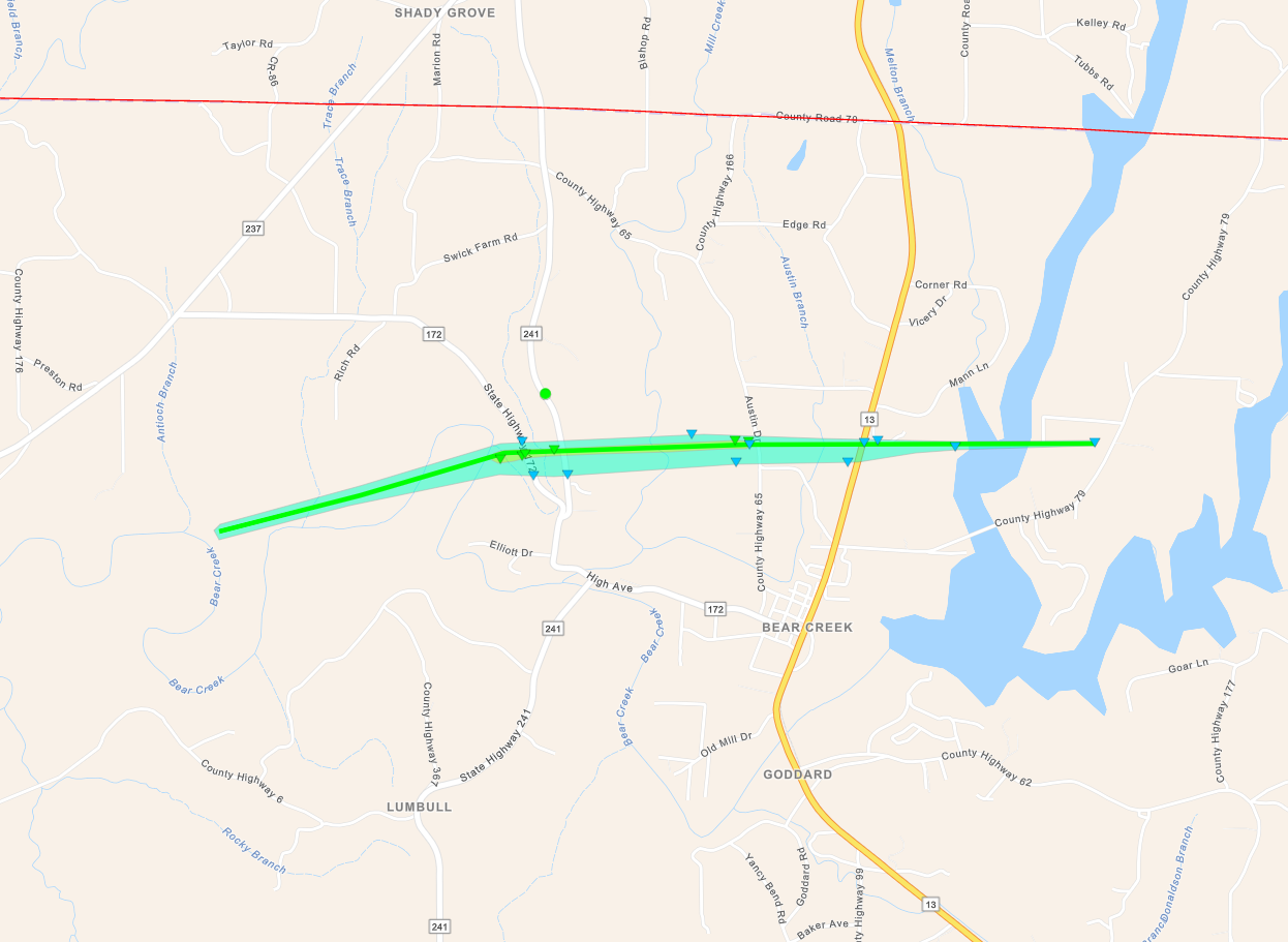
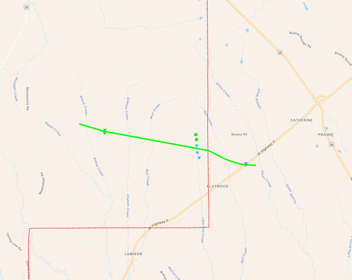
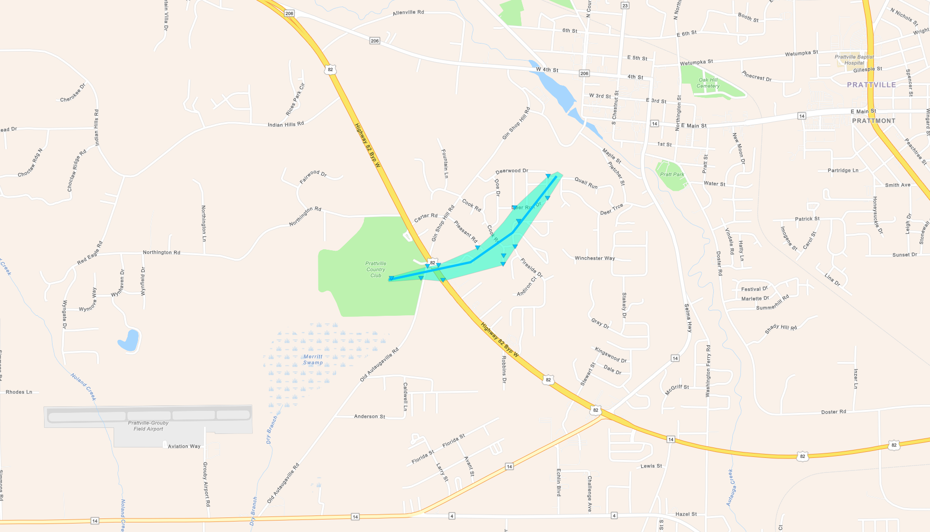
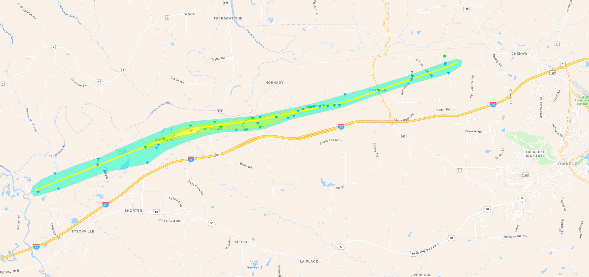
Along the Autauga/Elmore line, straight-line winds were estimated to have reached 80 mph. These winds occurred around 9:45 pm on Sunday, March 26th over a distance of about 1.65 miles.

Survey summary: 

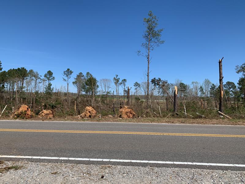
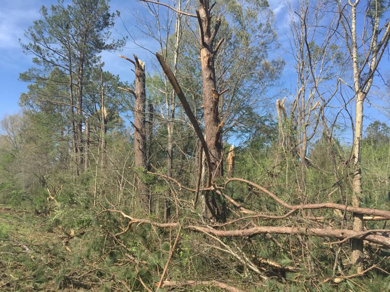
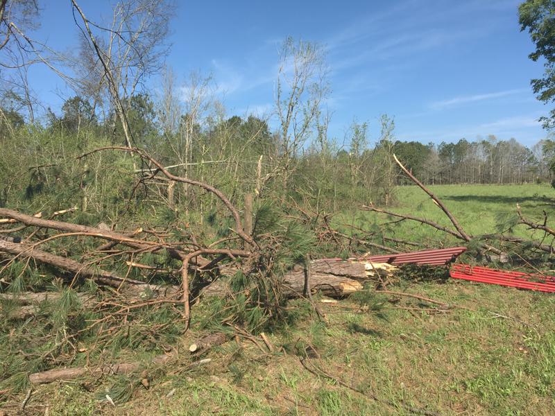
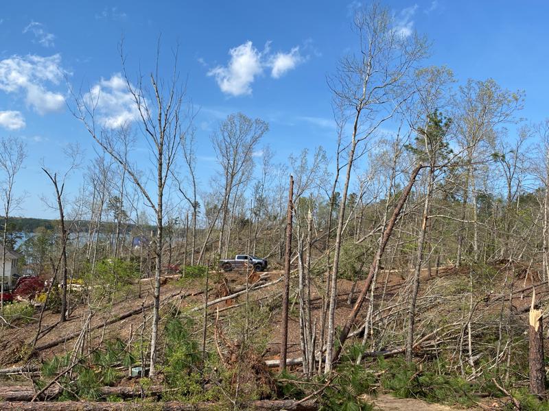
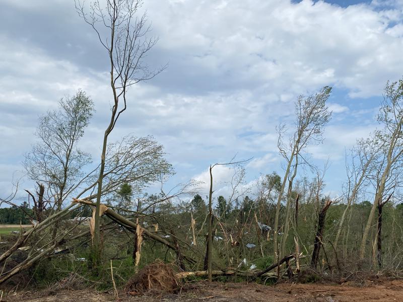
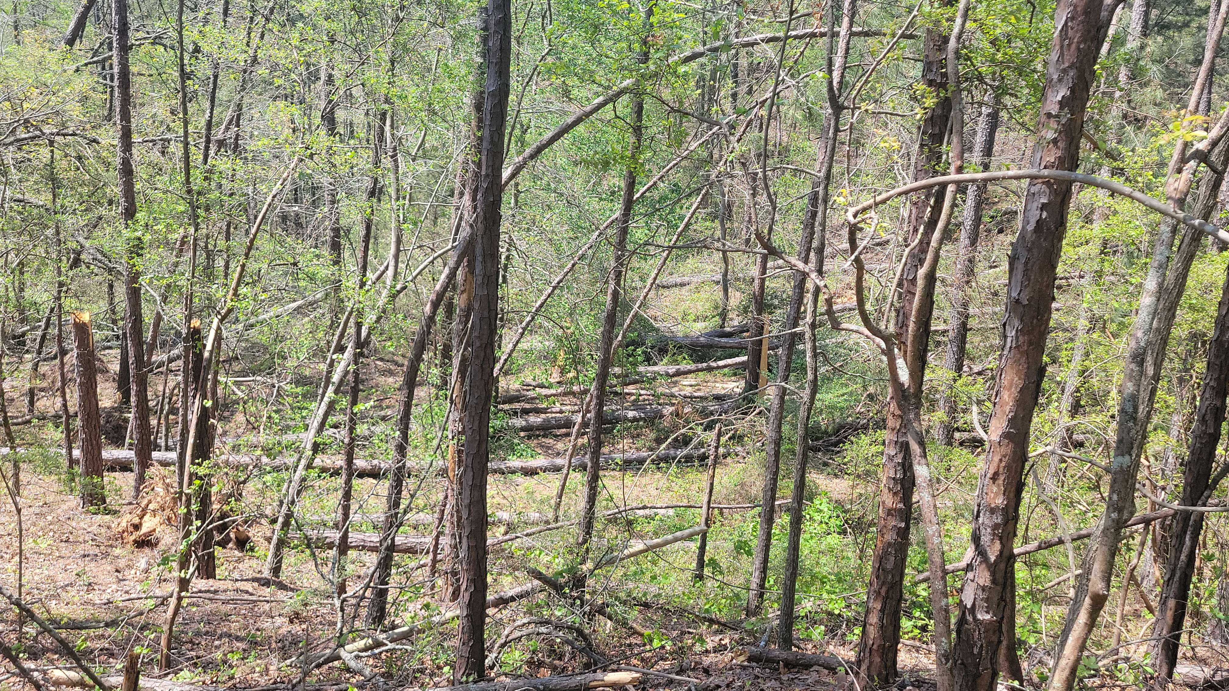
National Weather Service Meteorologists surveyed storm damage in Eastern Autauga and Western Elmore County and determined it was caused by straight line winds associated with a bowing segment of thunderstorms.  While broad rotation associated with a bookend vortex was noted in the vicinity of the damage near Autauga County Road 39 and Deatsville Highway in Elmore County, a swath of consistently divergent wind damage extended from southwest of the intersection of CR 39 and Gunnells Road along Ross Road, to the intersection of Ross Road and Deatsville Highway.  Damage was mainly limited to tree damage, and was indicative of fairly widespread wind speeds of 60 mph, with some pockets of damage
that indicated winds of about 80 mph.  The most significant tree fall occurred in a narrow valley with steep walls on either side
near the beginning of the swath, and then again with a patch of significant tree fall in Ross Cemetery, which was immediately
downstream of an open field.  The wind damage decreased as the feature crossed Deatsville Highway, and dissipated shortly beyond that location.  Worthy of note is that outside of this concentrated area of wind damage, there were numerous other
reports of isolated tree damage scattered throughout the area that were consistent with widespread wind damage associated with the bowing segment that was evident on radar.


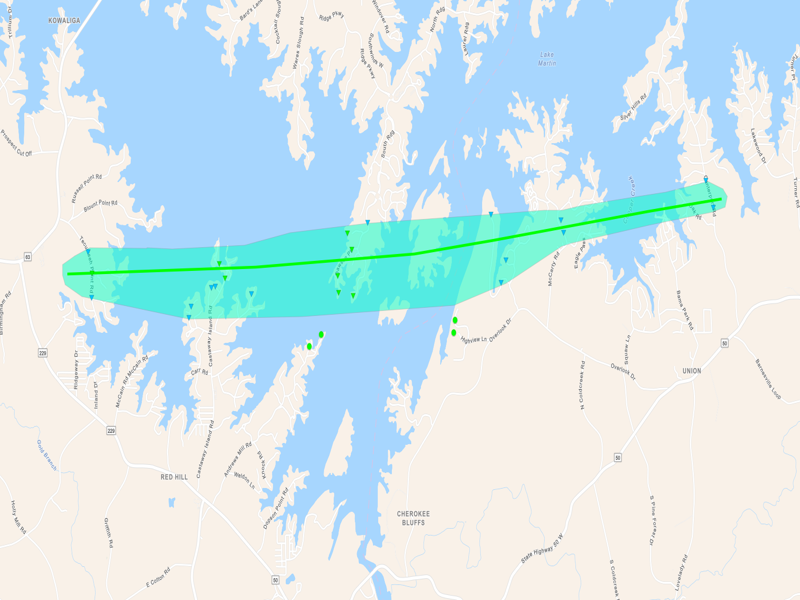
In western Elmore County, straight-line winds were estimated to have reached 85 mph. These winds occurred around 9:44 pm on Sunday, March 26th over a distance of about 1.95 miles near the Wetumpka Municipal Airport.

Survey summary: 

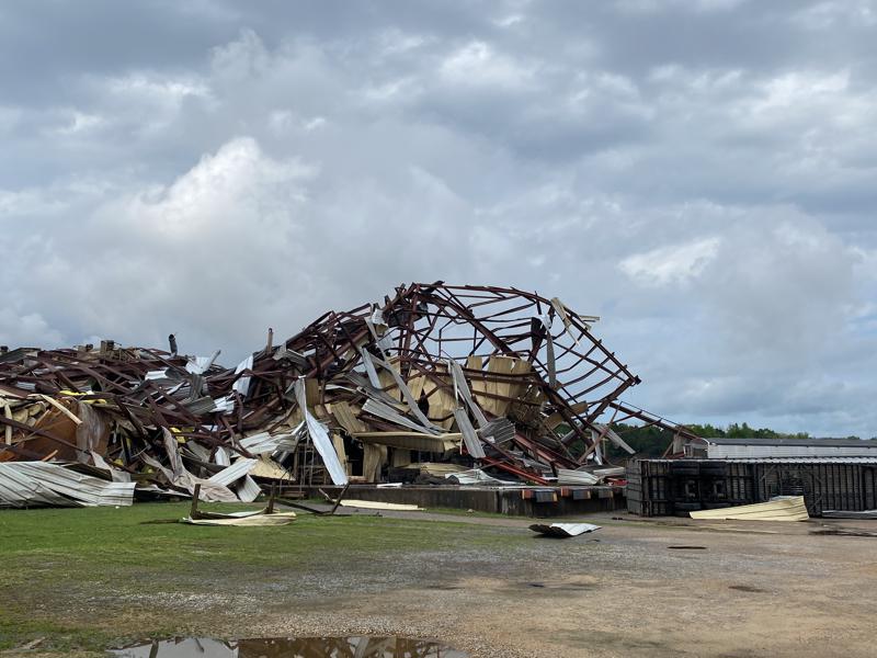
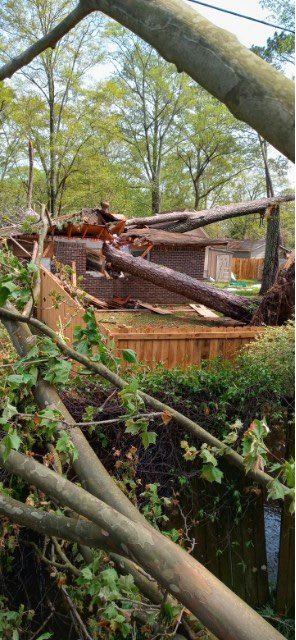
National Weather Service Meteorologists surveyed an area of storm damage along and near Airport Road, southwest of the town of Elmore, and determined that it was caused by straight line winds. Strong winds of up to 85 mph surging out ahead of the crest of a bowing segment of thunderstorms resulted in tree, powerline, and home damage largely from fallen trees on and along Airport Road that extended from the Overton Heights community to the Wetumpka Municipal Airport.  The most significant damage was to homes across the street from the airport`s grass runway along Meadow Lane Drive and Hillhedge Road, where several homes received major damage from large fallen trees.  This concentrated area of wind damage was just a portion of the more widespread scattered wind damage in the area that was consistent with the bowing segment evident on radar.


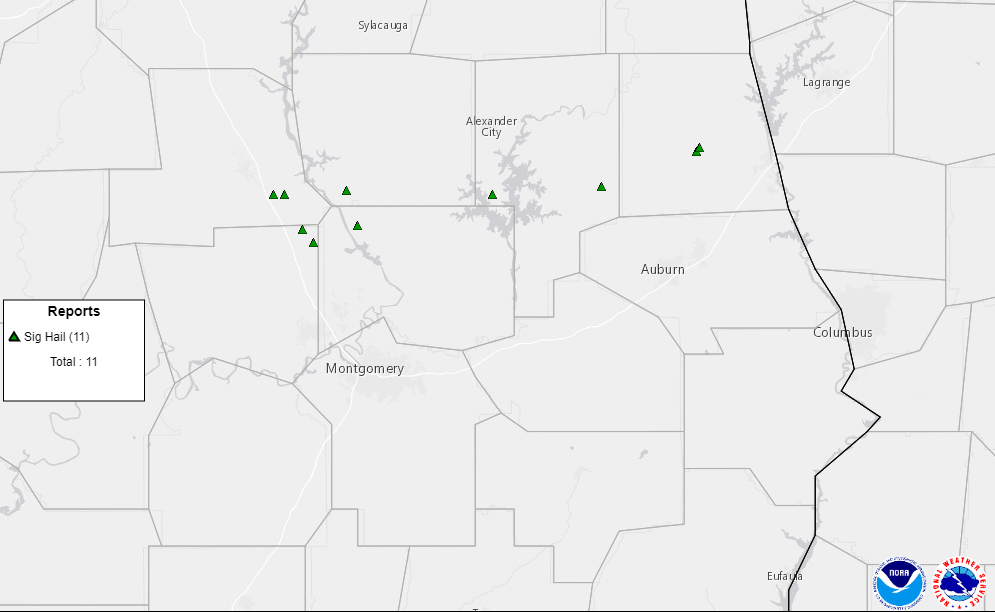
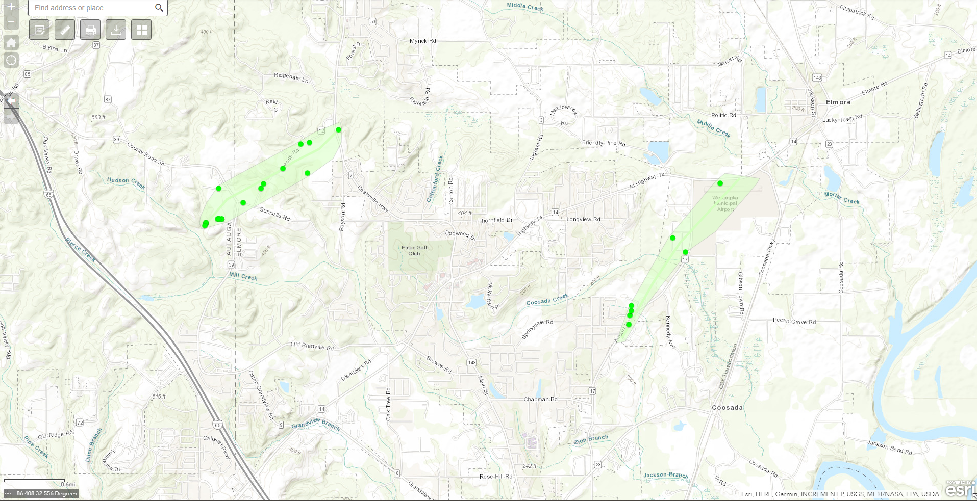
The below map shows the two areas of straight-line wind damage that were surveyed. 


Damage Photo
 Near CR 39 along the Autauga/Elmore county line.
Damage Photo
 Multiple trees downed, some onto a home on Meadow Lane Drive in Elmore, AL.
 
Heavy Rain and Flooding
 

 Notable Flooding (Chambers, Chilton, Clay, Coosa, Randolph, and Tallapoosa Counties)


Several inches of rain fell as multiple waves of storms moved across the same areas repeatedly. Some locations experienced washed out or impassible roadways.


Damage Photo
 Road washed out in Chilton County
Source: Allen Ray

Damage Photo
 Road washed outCounty Road 98 in Lafayette in Chambers County. Source: Myles Welch


Outlooks & Reports
 

Day 3 Outlook
Local Day 2 Outlook
March 23 at 342 am CDT

This outlook covered storms Friday night into Saturday morning.

Day 2 Outlook
Local Day 2 Outlook
March 23 at 413 am CDT

This outlook covered the multiple waves of severe storms expected Sunday morning into Sunday night.

Day 1 Outlook
Local Day 1 Outlook
March 26 at 355 am

This outlook upgrade covered the multiple waves of ongoing and additional severe storms expected through Sunday night.

Storm Reports
Storm Reports
March 24-25

Storm ReportsStorm Reports
March 25-26

Storm ReportsStorm Reports
March 26-27

Surface Charts
 

Surface Chart
Surface Analysis
March 24 at 7 am CDT

Surface Chart
Surface Analysis
March 25 at 7 am CDT

Surface Chart
Surface Analysis
March 26 at 7 am CDT

Surface Chart
Surface Analysis
March 27 at 7 am CDT


Upper Air Charts
 

250 mb
250 mb Analysis
March 24 at 7 pm CDT

500 mb
500 mb Analysis
March 24 at 7 pm CDT

850 mb
850 mb Analysis
March 24 at 7 pm CDT

250 mb
250 mb Analysis
March 27 at 7 am CDT

500 mb
500 mb Analysis
March 27 at 7 AM CDT

850 mb
850 mb Analysis
March 27 at 7 am CDT

KBMX Sounding
KBMX Sounding
March 24 7 pm CDT

KBMX Sounding
KJAN Sounding
March 26 7 am CDT

BMX was not able to launch a balloon due to storms in the area. JAN's sounding shows a similar environment to central Alabama with strong, deep wind shear and a lot of instability aloft.

KBMX Sounding
KBMX Sounding
March 26 7 pm CDT