|
Event Summary
|
|
EF-2
|
|
Estimated Maximum Wind:
|
120 mph
|
|
Injuries/Fatalities:
|
None |
|
Damage Path Length:
|
8.58 miles
|
|
Maximum Path Width:
|
650 yards
|
|
Approximate Start Point/Time:
|
1 WNW Holtville
32.6413/-86.3385
at 932 pm
|
|
Approximate End Point/Time:
|
3 NE Ten Cedars Estates
32.6899/-86.2044
at 948 pm
|
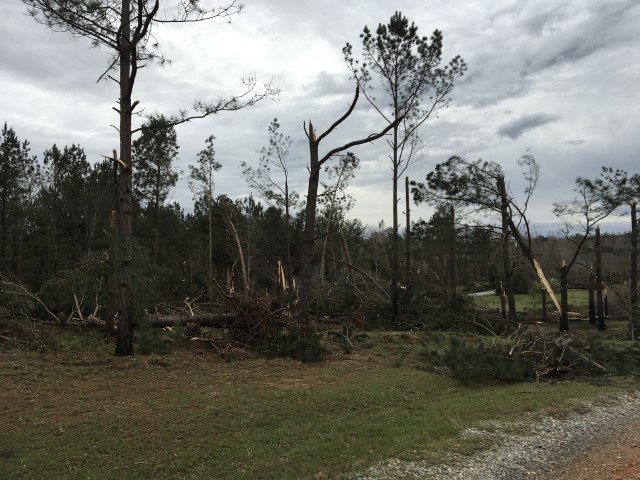
NWS Meteorologists surveyed damage in northwest Elmore County and determined it was the result of a tornado.
The tornado touched down near Shoal Creek Drive on the western shores of Jordan Lake. The initial damage was rather weak and confined to tree damage. But the tornado intensified quickly as it moved across Blackberry Road. Many homes suffered minor roof damage and numerous trees were snapped off and were uprooted. Several landed on homes. The tornado then crossed Jordan Lake and caused extensive damage on Red Bone Drive, Speigner Road, Shady Lane Road, Jones Corner Road, Montana Drive and Dakota Drive. Hundreds of trees were downed, many power poles were downed and several homes suffered roof damage. The tornado continued northeastward and crossed Thornton Road. This is where the strongest damage occurred. Several homes lost entire roofs and a few walls in this location. The continued northeast and crossed US Highway 231 and then produced damaged down Laurel Creek Road. One service station sustained extensive damage and numerous trees and power lines were downed in this area. The tornado paralleled Laurel Creek Road and knocked trees down until lifting just before Antioch Road. Over the entire path, at least 35 power poles were snapped and downed, at least 50 structures suffered damage, 2 convenience stores were damaged, a few homes had roofs removed and walls collapsed, and one car was moved over 30 yards. Some path adjustments may be made after some drone footage is reviewed.
Special thanks to the Elmore County EMA for their assistance in the survey.
|