NWS Birmingham, Alabama
Weather Forecast Office
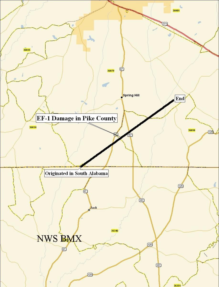
Spring Hill Tornado - February 17, 2008
|
Rating:
(Click for EF Scale) |
EF-1 / All numbers subject to change when entire path is determined
|
|
Maximum Wind:
|
100 mph
|
|
Injuries/Fatalities:
|
None
|
|
Path Length:
|
8.3 miles
|
|
Maximum Path Width:
|
250 yards
|
|
Start:
|
31.6190/-86.0116 at 223 PM
|
|
End:
|
31.6894/-85.8959 at 234 PM
|
A National Weather Service Damage Assessment Team has surveyed the damage in southern Pike county. It has been determined the damage was the result of a tornado. The tornado has been rated an EF-1 on the Enhanced Fujita Scale, but this rating is based on damage only in Pike County. The tornado was on the ground in Coffee and possibly further south. Damage estimates were consistent with winds around 100 mph in Pike County.
The tornado entered Pike County from Coffee County approximately 5 miles southeast of Henderson. The tornado crossed State Highways 87 and 167 and ended just north of the intersection of County Roads 6 and 57. This storm tracked across counties in both Mobile`s and Tallahassee`s Area of Responsibility. In Pike County, one home and one church were damaged and numerous trees were either snapped off or were uprooted along the path. The tornado entered Pike County at about 223 pm and lifted at 234 pm. A Tornado Warning was in effect from 150 pm until 245 pm.
Current Hazards
National Outlooks
Tropical
Local Storm Reports
Public Information Statement
Graphical Hazardous Weather Outlook
Current Conditions
Regional Weather Roundup
Rivers and Lakes
Drought Monitor
Forecasts
Aviation Weather
Graphical Forecasts
Forecast Discussion
Air Quality
Fire Weather
Climate and Past Weather
Past Events
Storm Data
Tornado Database
Daily Rainfall Plots
Tropical Cyclone Reports
Monthly Climate
Annual Climate
Warnings and Other Products
Tornado Warnings
Severe Thunderstorm Warnings
Flash Flood Warnings
Winter Weather Warnings
Special Weather Statements
Non-Precipitation Warnings
Flood/River Flood Warnings
Productos en Español
Conciencia y Preparación
Previsión de 7 Días
Weather Safety
NOAA Weather Radio
Severe Weather Preparedness
Severe Safety Rules
Tornado Safety Rules
Severe Safety w/ ASL
Awareness Weeks
Severe Weather
Hurricane Preparedness
Summer Safety Campaign
Winter Weather
US Dept of Commerce
National Oceanic and Atmospheric Administration
National Weather Service
NWS Birmingham, Alabama
465 Weathervane Road
Calera, AL 35040
205-664-3010
Comments? Questions? Please Contact Us.

