NWS Birmingham, Alabama
Weather Forecast Office
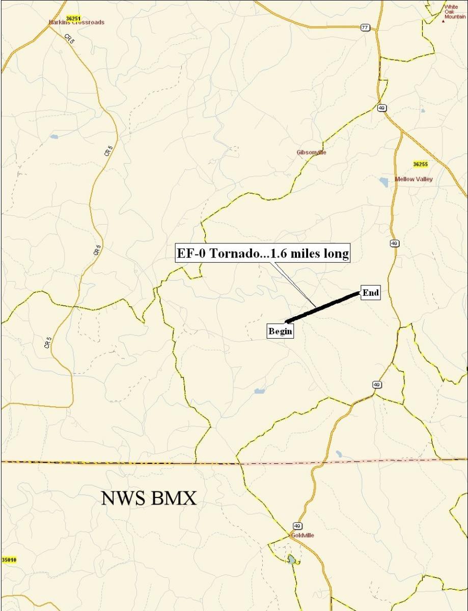
Mellow Valley Tornado - February 17, 2008
|
Rating:
(Click for EF Scale) |
EF-0
|
|
Maximum Wind:
|
75 mph
|
|
Injuries/Fatalities:
|
None
|
|
Path Length:
|
1.6 miles
|
|
Maximum Path Width:
|
50 yards
|
|
Start:
|
33.1452/-85.7857 at 203 PM
|
|
End:
|
33.1537/-85.7607 at 205 PM
|
A National Weather Service Damage Assessment Team has surveyed the damage in southeastern Clay County and it has been determined that the damage was the result of a weak tornado. The tornado has been rated an EF-0 on the Enhanced Fujita Scale. Damage estimates were consistent with winds between 70 and 75 mph. The tornado damage path was 1.6 miles long and was 50 yards wide at its widest point. The tornado touched down near Fuller Road where minimal tree damage occurred and one home sustained roof damage. It then tracked northeast before lifting near catfish road. Red's Catfish Cabin had a small part of the roof torn off. Several trees were snapped off along the short path. One vehicle was partially lifted into the air and the roof debris was deposited underneath it. There were approximately 100 people in the catfish restaurant when the tornado hit. These people were in the basement after the owner took action when hearing the warning. No injuries were reported. The tornado touched down at approximately 203 pm and was on the ground for only about a minute. A Severe Thunderstorm Warning was in effect from 127 pm until 230 pm. A Tornado Warning was in effect from 140 pm until 215 pm.
 Tornado Damage Path |
Current Hazards
National Outlooks
Tropical
Local Storm Reports
Public Information Statement
Graphical Hazardous Weather Outlook
Current Conditions
Regional Weather Roundup
Rivers and Lakes
Drought Monitor
Forecasts
Air Quality
Fire Weather
Aviation Weather
Graphical Forecasts
Forecast Discussion
Climate and Past Weather
Past Events
Storm Data
Tornado Database
Daily Rainfall Plots
Tropical Cyclone Reports
Monthly Climate
Annual Climate
Warnings and Other Products
Tornado Warnings
Severe Thunderstorm Warnings
Flash Flood Warnings
Winter Weather Warnings
Special Weather Statements
Non-Precipitation Warnings
Flood/River Flood Warnings
Productos en Español
Conciencia y Preparación
Previsión de 7 Días
Weather Safety
NOAA Weather Radio
Severe Weather Preparedness
Severe Safety Rules
Tornado Safety Rules
Severe Safety w/ ASL
Awareness Weeks
Severe Weather
Hurricane Preparedness
Summer Safety Campaign
Winter Weather
US Dept of Commerce
National Oceanic and Atmospheric Administration
National Weather Service
NWS Birmingham, Alabama
465 Weathervane Road
Calera, AL 35040
205-664-3010
Comments? Questions? Please Contact Us.

