NWS Birmingham, Alabama
Weather Forecast Office
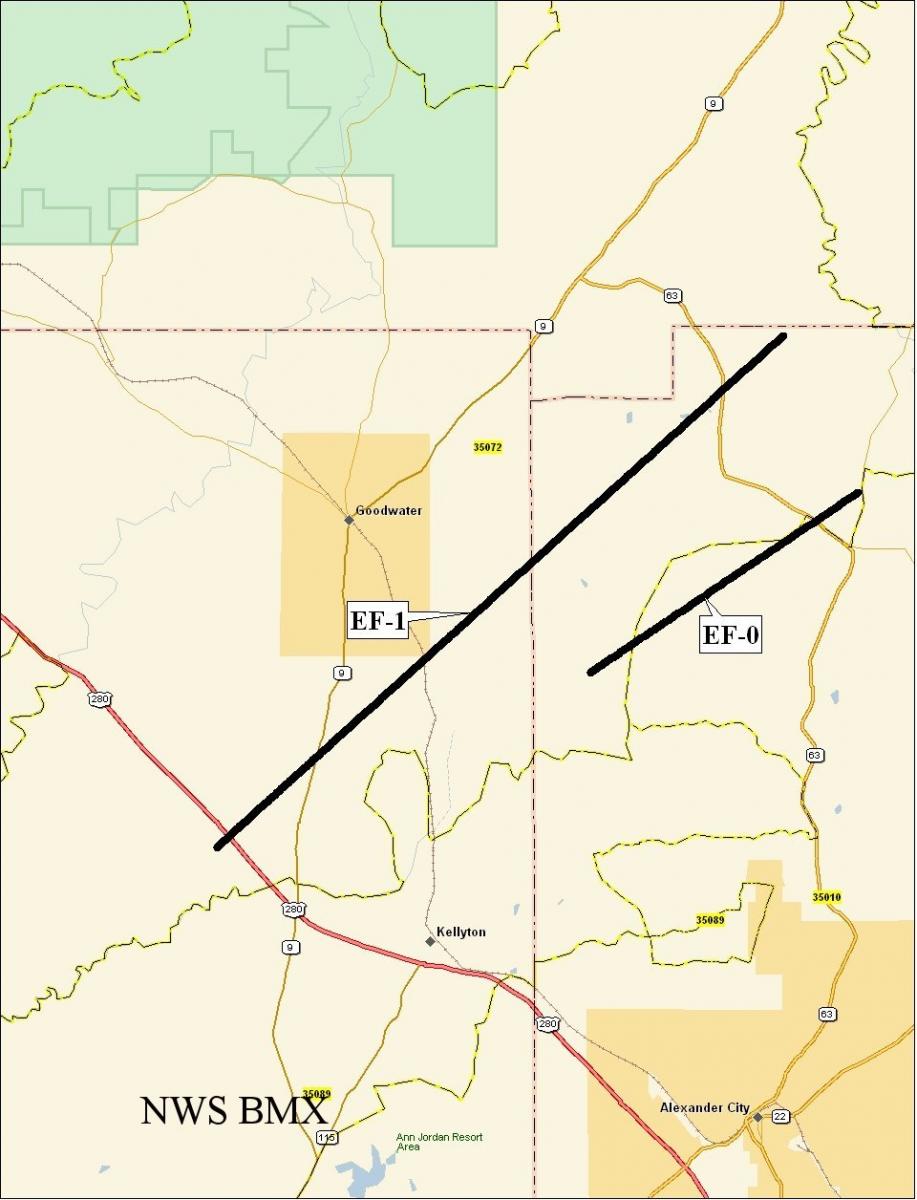
Goodwater Tornado - February 17, 2008
|
Rating:
(Click for EF Scale) |
EF-1
|
|
Maximum Wind:
|
95 mph
|
|
Injuries/Fatalities:
|
None
|
|
Path Length:
|
10.7 miles
|
|
Maximum Path Width:
|
100 yards
|
|
Start:
|
32.9988/-86.0854 at 142 PM
|
|
End:
|
33.1035/-85.9480 at 153 PM
|
A National Weather Service Assessment team surveyed the storm damage in Coosa and Tallapoosa Counties. It has been determined that the damage was the result of a tornado. The tornado has been rated an EF-1 on the Enhanced Fujita Scale. Damage estimates were consistent with winds around 95 mph. The tornado damage path was 10.7 miles long and was 100 yards wide at its widest point.
The tornado touched down along US Highway 280 near the Bradford Community. The tornado moved northeastward and crossed State Highway 9, County Roads 77/83/85, Goodwater Road, State Highway 63. The tornado lifted near the Tallapoosa and Clay County line northeast of State Highway 63. A large majority of the damage was EF-0 and limited to broken limbs and snapped softwood trees. The most significant damage occurred near County Road 77 and State Highway 9. At least 6 homes suffered varying degrees of damage along the path. At least three automobiles were majorly damaged by fallen trees. Numerous outbuildings and barns were either damaged or destroyed along the path. The tornado was on the ground from approximately 142 pm until 153 pm.
Current Hazards
National Outlooks
Tropical
Local Storm Reports
Public Information Statement
Graphical Hazardous Weather Outlook
Current Conditions
Regional Weather Roundup
Rivers and Lakes
Drought Monitor
Forecasts
Aviation Weather
Graphical Forecasts
Forecast Discussion
Air Quality
Fire Weather
Climate and Past Weather
Past Events
Storm Data
Tornado Database
Daily Rainfall Plots
Tropical Cyclone Reports
Warnings and Other Products
Tornado Warnings
Severe Thunderstorm Warnings
Flash Flood Warnings
Winter Weather Warnings
Special Weather Statements
Non-Precipitation Warnings
Flood/River Flood Warnings
Productos en Español
Conciencia y Preparación
Previsión de 7 Días
Weather Safety
NOAA Weather Radio
Severe Weather Preparedness
Severe Safety Rules
Tornado Safety Rules
Severe Safety w/ ASL
Awareness Weeks
Severe Weather
Hurricane Preparedness
Summer Safety Campaign
Winter Weather
US Dept of Commerce
National Oceanic and Atmospheric Administration
National Weather Service
NWS Birmingham, Alabama
465 Weathervane Road
Calera, AL 35040
205-664-3010
Comments? Questions? Please Contact Us.

