NWS Birmingham, Alabama
Weather Forecast Office
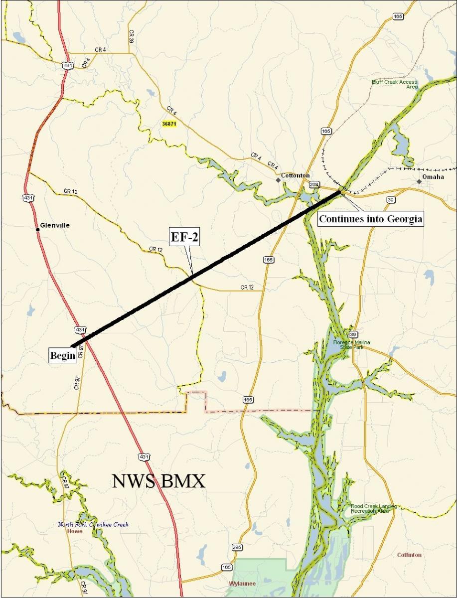
Cottonton Tornado - February 17, 2008
|
Rating:
(Click for EF Scale) |
EF-2/Tornado may have been on the ground into Georgia and all numbers may change when entire path is determined
|
|
Maximum Wind:
|
125 mph
|
|
Injuries/Fatalities:
|
4 injuries
|
|
Path Length:
|
7.73 miles
|
|
Maximum Path Width:
|
1000 yards
|
|
Start:
|
32.0864/-85.1621at 340 PM
|
|
End:
|
32.1424/-85.0478 at 352 PM
|
A National Weather Service Damage Assessment Team has surveyed the damage in Russell County and it has been determined the damage was the result of a tornado. The tornado has been rated an EF-2 on the Enhanced Fujita Scale. Damage estimates were consistent with winds around 125 mph. The tornado damage path in Alabama was 7.8 miles long and was one mile wide at its widest point.
The tornado touched down near the intersection of US Highway 431 and County Road 51 in the southern portion of the county. The tornado tracked northeastward to at least the Chattahoochee River near the Cottonton community. The most significant damage was located near County Road 12. At least two mobile homes were destroyed and two frame houses received significant damage. Numerous trees were either snapped off or were uprooted along the path. At least one vehicle was flipped over. This was on the ground in Russell County from 340 pm until 351 pm. A Tornado Warning was in effect from 337 pm until 415 pm. Four injuries were a direct result of this tornado. Some of path information may change if it is determined the tornado was on the ground into Georgia.
Current Hazards
National Outlooks
Tropical
Local Storm Reports
Public Information Statement
Graphical Hazardous Weather Outlook
Current Conditions
Regional Weather Roundup
Rivers and Lakes
Drought Monitor
Forecasts
Forecast Discussion
Air Quality
Fire Weather
Aviation Weather
Graphical Forecasts
Climate and Past Weather
Past Events
Storm Data
Tornado Database
Daily Rainfall Plots
Tropical Cyclone Reports
Warnings and Other Products
Tornado Warnings
Severe Thunderstorm Warnings
Flash Flood Warnings
Winter Weather Warnings
Special Weather Statements
Non-Precipitation Warnings
Flood/River Flood Warnings
Productos en Español
Conciencia y Preparación
Previsión de 7 Días
Weather Safety
NOAA Weather Radio
Severe Weather Preparedness
Severe Safety Rules
Tornado Safety Rules
Severe Safety w/ ASL
Awareness Weeks
Severe Weather
Hurricane Preparedness
Summer Safety Campaign
Winter Weather
US Dept of Commerce
National Oceanic and Atmospheric Administration
National Weather Service
NWS Birmingham, Alabama
465 Weathervane Road
Calera, AL 35040
205-664-3010
Comments? Questions? Please Contact Us.

