NWS Birmingham, Alabama
Weather Forecast Office
Tornadoes and Large Hail - February 13, 2007
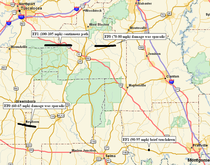
Severe thunderstorms moved across central Alabama on Tuesday February 13th. The thunderstorms crossed the Mississippi and Alabama state line around 330 PM CST...and continued eastward before weakening in southeastern Alabama around 9 PM CST. Several instances of large hail (up to the size of baseballs) and damaging winds were reported. During this severe weather episode, 4 tornado (2 EF1s and 2 EF0s) damage paths were discovered.
A Severe Thunderstorm Watch was in effect from 12:50 PM CST until 8 PM CST for counties along and west of Interstate 65. The watch was later upgraded to a Tornado Watch, adding the rest of central Alabama, valid from around 5 PM CST until 10 PM CST.
Click the tornado path on the map below for the survey details.
 |
||||||||
Preliminary Local Storm Report...Click Here
Current Hazards
National Outlooks
Tropical
Local Storm Reports
Public Information Statement
Graphical Hazardous Weather Outlook
Current Conditions
Regional Weather Roundup
Rivers and Lakes
Drought Monitor
Forecasts
Graphical Forecasts
Forecast Discussion
Air Quality
Fire Weather
Aviation Weather
Climate and Past Weather
Past Events
Storm Data
Tornado Database
Daily Rainfall Plots
Tropical Cyclone Reports
Warnings and Other Products
Tornado Warnings
Severe Thunderstorm Warnings
Flash Flood Warnings
Winter Weather Warnings
Special Weather Statements
Non-Precipitation Warnings
Flood/River Flood Warnings
Productos en Español
Conciencia y Preparación
Previsión de 7 Días
Weather Safety
NOAA Weather Radio
Severe Weather Preparedness
Severe Safety Rules
Tornado Safety Rules
Severe Safety w/ ASL
Awareness Weeks
Severe Weather
Hurricane Preparedness
Summer Safety Campaign
Winter Weather
US Dept of Commerce
National Oceanic and Atmospheric Administration
National Weather Service
NWS Birmingham, Alabama
465 Weathervane Road
Calera, AL 35040
205-664-3010
Comments? Questions? Please Contact Us.

