NWS Birmingham, Alabama
Weather Forecast Office
Super Tuesday Tornado Outbreak February 5th & 6th, 2008
Event Summary for Central Alabama
A warm front moved northward across Central Alabama early Monday February 5th. The southerly flow behind this warm front brought an unseasonably warm and moist airmass northward and into Central Alabama. The southerly flow, occasionally gusting to 30 mph or more, continued Monday and Tuesday. Afternoon high temperatures were near record levels and rose into the 70s and 80s each afternoon. The surface dew points surged into the 60s indicating a very moist environment.
A strong upper level system and its accompanying surface cold front approached Central Alabama just after midnight on February 6th. With the warm and unstable airmass in place, the added lift sparked several supercell thunderstorms. These supercells produced damage in many locations across Central Alabama. Supercell thunderstorms exhibit persistent rotation through a depth of the atmosphere and freqently produce tornadoes, wind damage and large hail.
This severe weather event was not limited to Central Alabama. Numerous tornadoes occurred across the Mid-South, Tennessee Valley, Ohio Valley and parts of the Deep South.
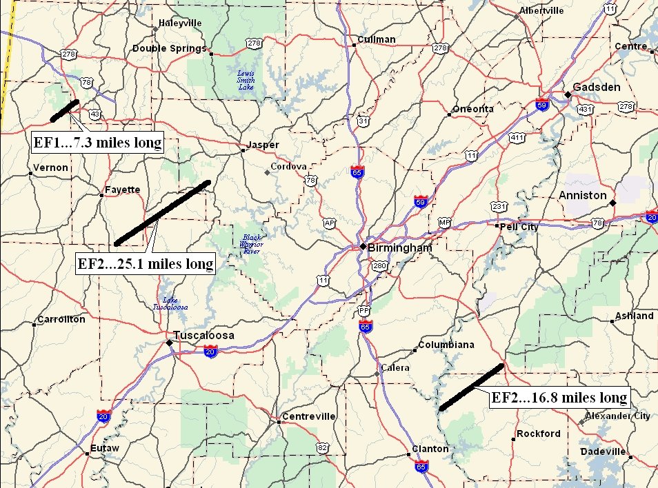
The following tornado damage paths have been identified in Central Alabama:
EF-1 Lamar & Marion Counties
EF-2 Fayette, Tuscaloosa & Walker Counties
EF-2 Coosa & Talladega CountiesPreliminary Local Storm Reports
Public Information Statement
Central Alabama Tornado Damage Paths
Severe Weather Episode Data
|
|
||||||||||||||||||||
Current Hazards
National Outlooks
Tropical
Local Storm Reports
Public Information Statement
Graphical Hazardous Weather Outlook
Current Conditions
Regional Weather Roundup
Rivers and Lakes
Drought Monitor
Forecasts
Air Quality
Fire Weather
Aviation Weather
Graphical Forecasts
Forecast Discussion
Climate and Past Weather
Past Events
Storm Data
Tornado Database
Daily Rainfall Plots
Tropical Cyclone Reports
Warnings and Other Products
Tornado Warnings
Severe Thunderstorm Warnings
Flash Flood Warnings
Winter Weather Warnings
Special Weather Statements
Non-Precipitation Warnings
Flood/River Flood Warnings
Productos en Español
Conciencia y Preparación
Previsión de 7 Días
Weather Safety
NOAA Weather Radio
Severe Weather Preparedness
Severe Safety Rules
Tornado Safety Rules
Severe Safety w/ ASL
Awareness Weeks
Severe Weather
Hurricane Preparedness
Summer Safety Campaign
Winter Weather
US Dept of Commerce
National Oceanic and Atmospheric Administration
National Weather Service
NWS Birmingham, Alabama
465 Weathervane Road
Calera, AL 35040
205-664-3010
Comments? Questions? Please Contact Us.


